


Progress in Spaceborne Passive Microwave Remote Sensing Technology and Its Application
-
摘要: 星载被动微波遥感是指利用高灵敏度接收机通过接收场景和目标的自然微波辐射来提取目标信息的一种遥感手段。被动微波遥感又称微波辐射计遥感。人类利用微波辐射计从空间进行对地遥感已有50多年的历史。目前,星载微波辐射计已经成为气象和海洋卫星的主载荷,在数值天气预报、海洋环境监测和全球变化研究中发挥着越来越重要的作用。本文分析了国内外星载被动微波遥感技术与应用进展,以及被动微波遥感技术发展趋势及其关键技术问题,针对中国星载被动微波遥感的定量化应用,在数据与数据处理流程,算法标准化、亮温和反演参数的定标/检验标准化等方面提出了一些思考和建议,以期望被动微波遥感数据被越来越广泛地得到应用,最大限度地提升星载地球被动微波遥感技术的应用效能。Abstract: Spaceborne passive microwave sensor is a kind of remote sensing that uses high-sensitivity receivers to detect natural microwave radiation from scenes and targets. Passive microwave remote sensor also refers to microwave radiometer. Microwave radiometers have been used for remote sensing of the Earth from space for more than fifty years. At present, microwave radiometers have become the main payload of meteorological and oceanographic satellites, playing an important role in numerical weather prediction, marine environment monitoring and global climate change research. This article analyzes and summarizes the following points. Firstly, passive microwave remote sensing technology and its application development. Secondly, the development trend of passive microwave remote sensing technology and its key technical issues. Thirdly, for the quantitative application of passive microwave remote sensing in China, some thoughts and suggestions are put forward in terms of product and data processing procedures, as well as standardization on algorithm for deriving different level products, calibration/validation of brightness temperature and geophysical parameters. The contents of this article aim at promoting much wider application of passive microwave remote sensing data and maximizing the application efficiency of passive microwave remote sensing technology.
-
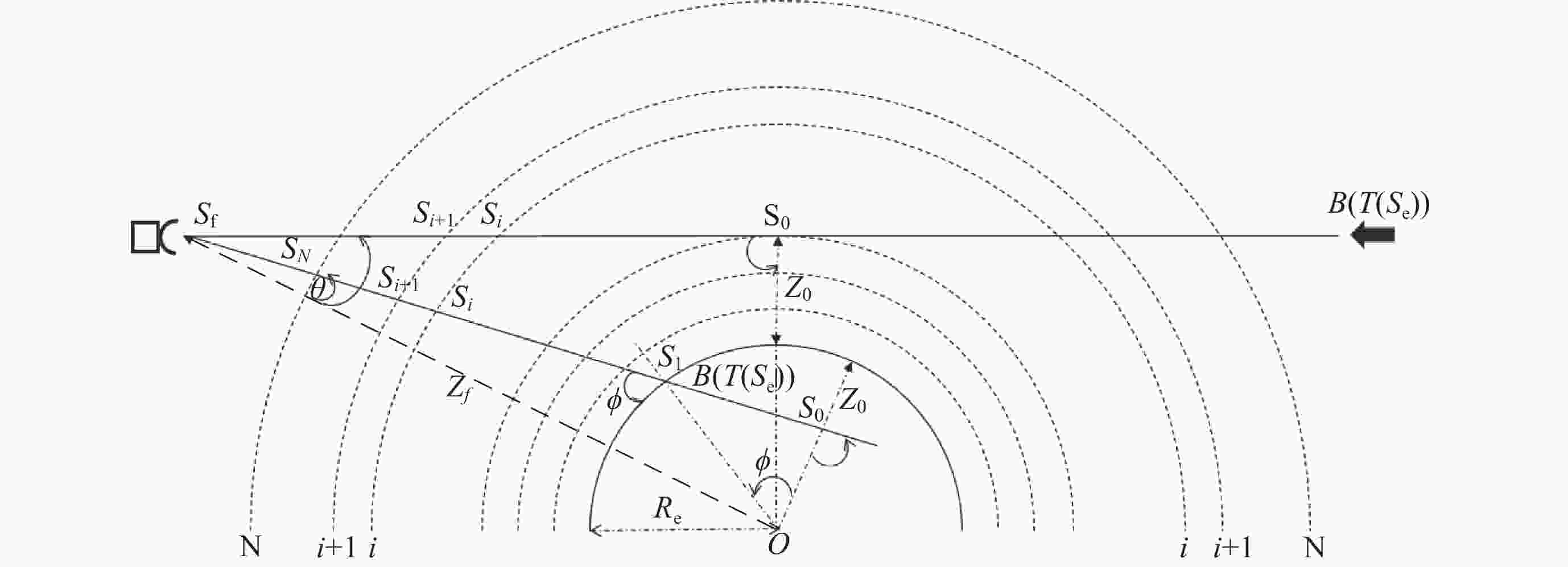
图 1 空间微波辐射计两种不同的观测几何示例
Figure 1. Two different observation geometries for spaceborne microwave radiometers
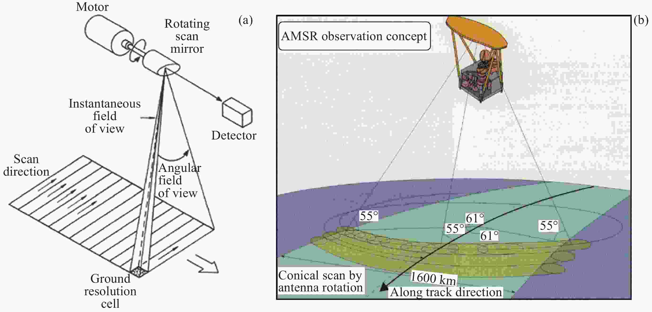
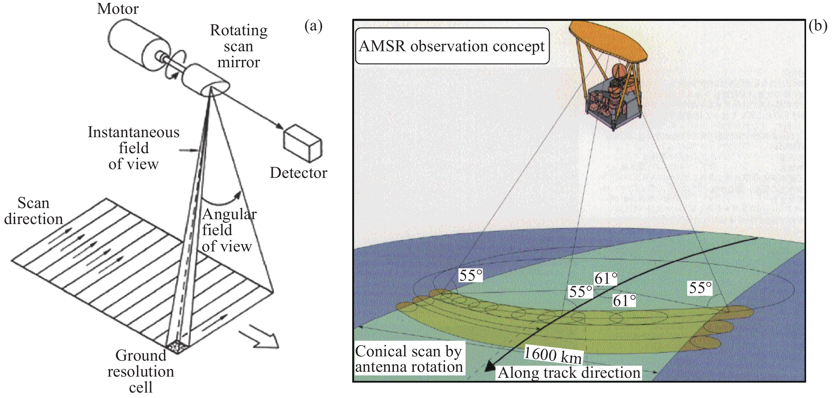
图 2 星载微波辐射计的扫描模式。(a)交轨扫描,(b)圆锥扫描
Figure 2. Scanning modes of spaceborne microwave radiometer. (a) Cross-scanning, (b) conical scanning of AMSR
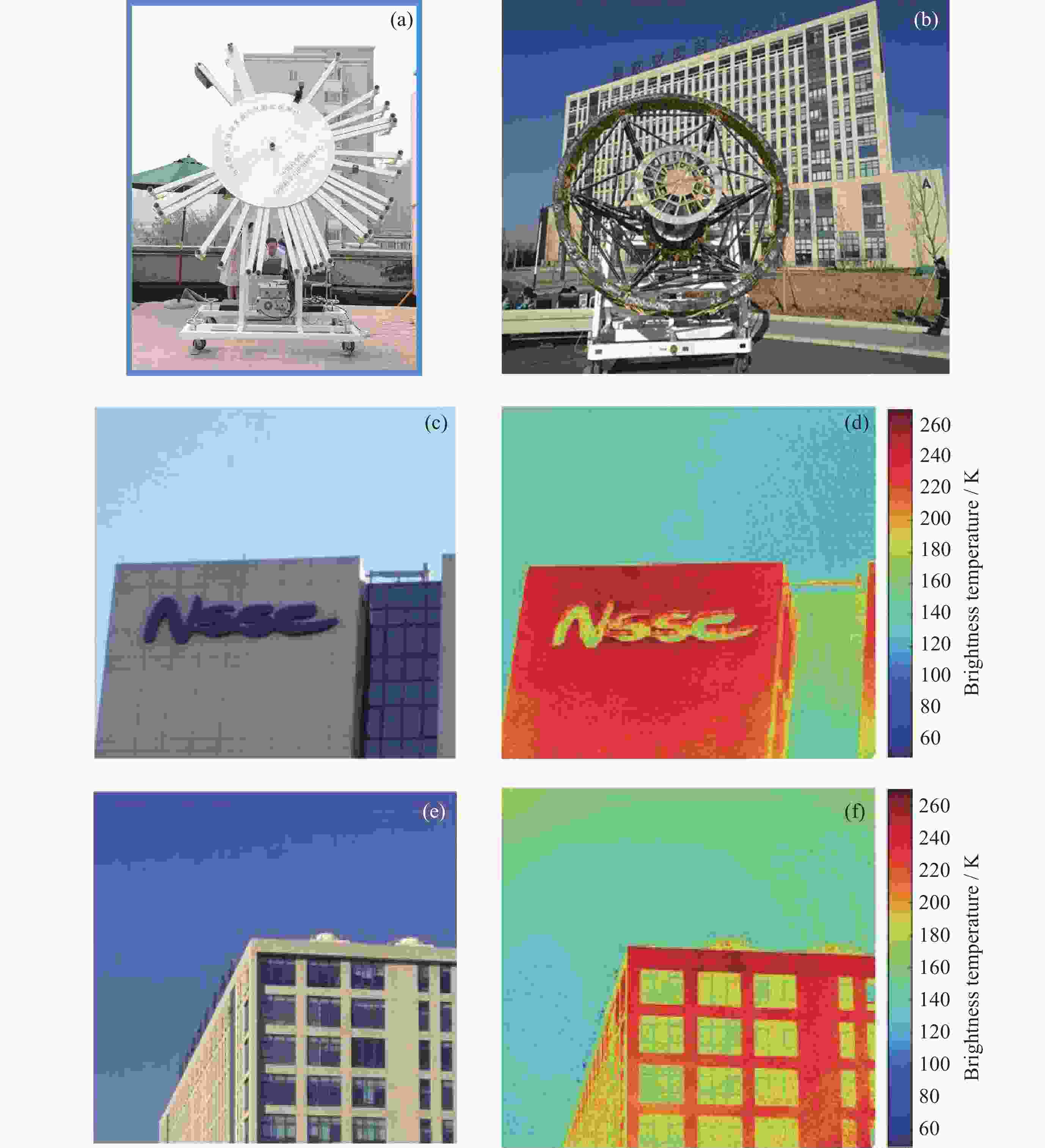
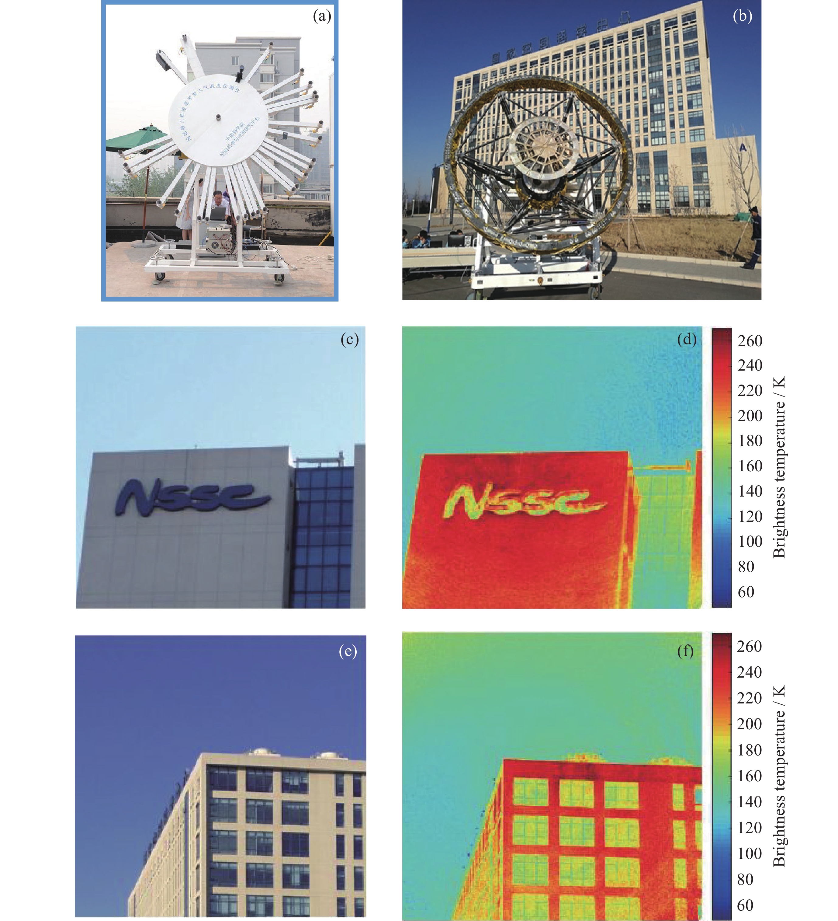
图 4 静止轨道大气微波探测仪地面样机。(a)第一代样机,(b)第二代样机,(c)(e)光学照片,(d)(f)对应的微波成像亮温
Figure 4. Ground prototype of the geostationary atmospheric microwave sounder. (a) First-generation prototype, (b) second-generation prototype, (c)(e) optics images, (d)(f) corresponding microwave brightness temperature
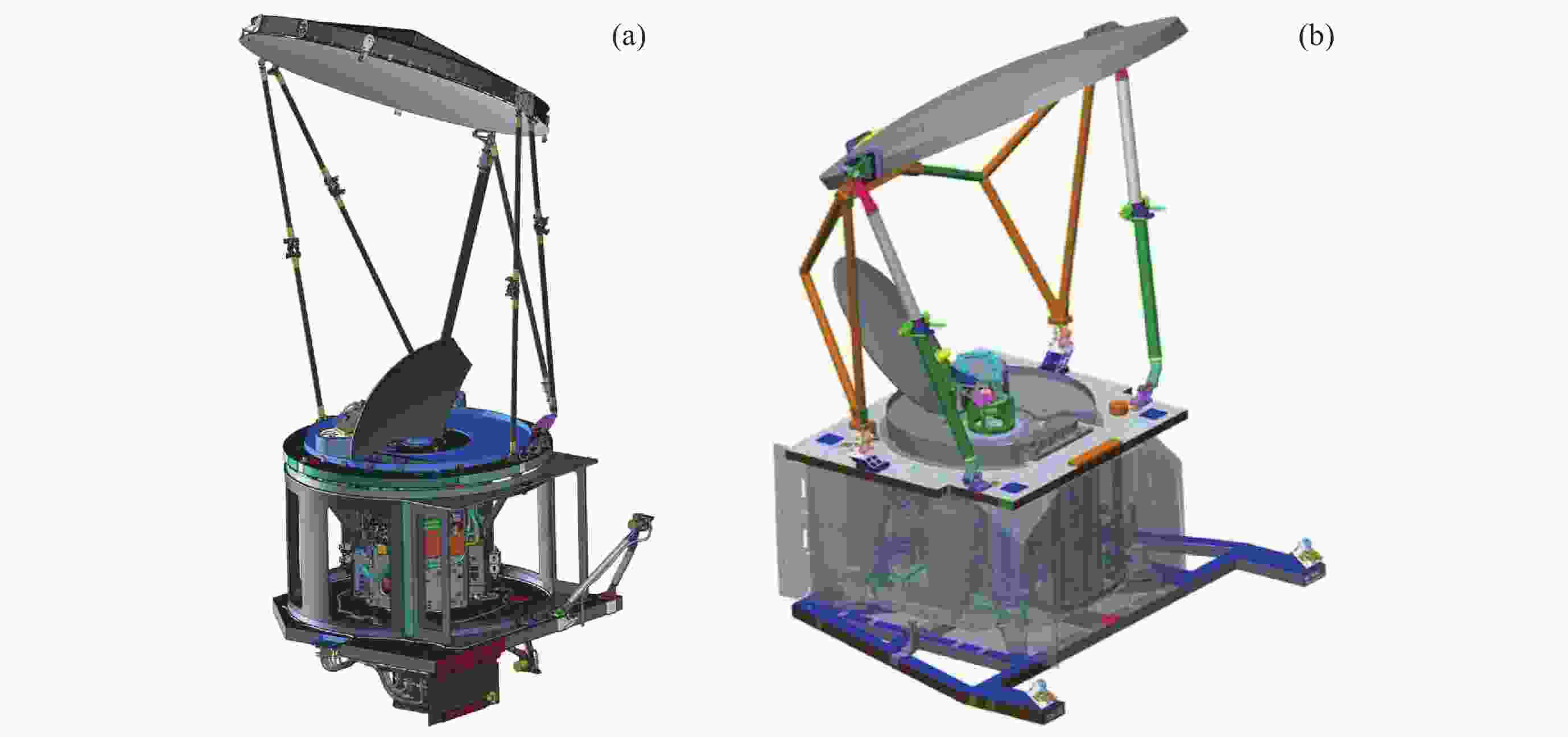
图 5 气象卫星微波成像仪比较。(a)GMI,(b)MWRI-2
Figure 5. Comparison of meteorological satellite microwave imagers. (a) GMI, (b) MWRI-2
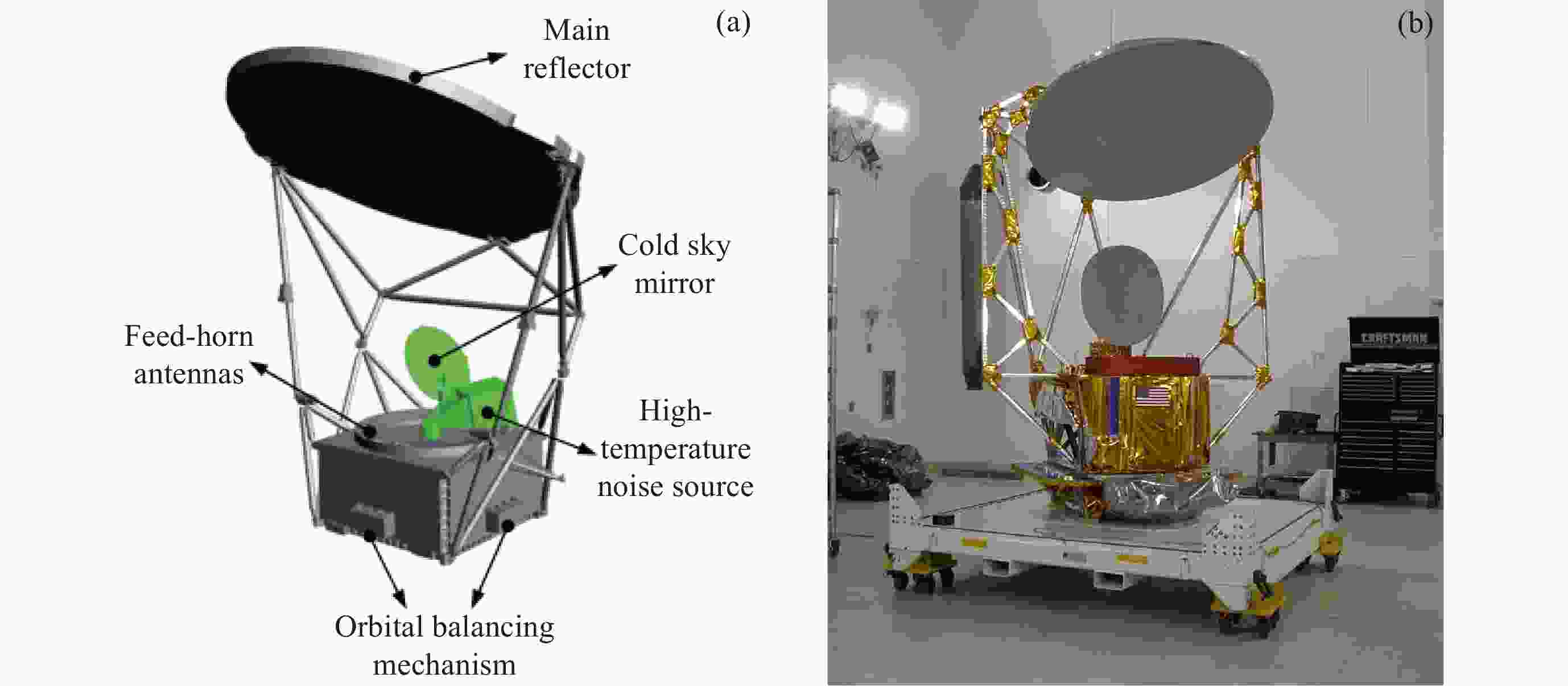
图 6 国外海洋卫星微波成像仪比较。(a)AMSR2,(b)WindSat
Figure 6. Comparison of oversea ocean microwave imager. (a) AMSR2, (b) WindSat
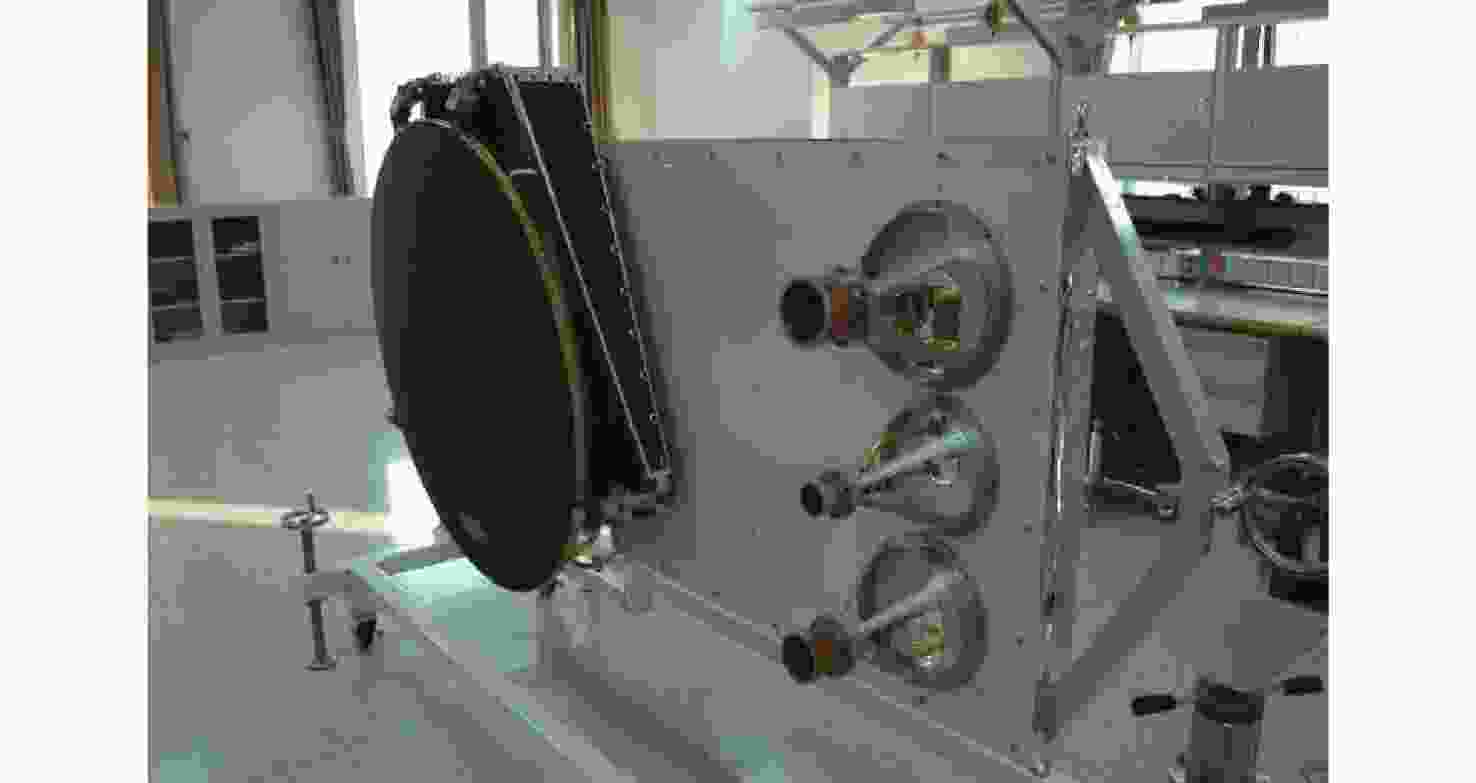
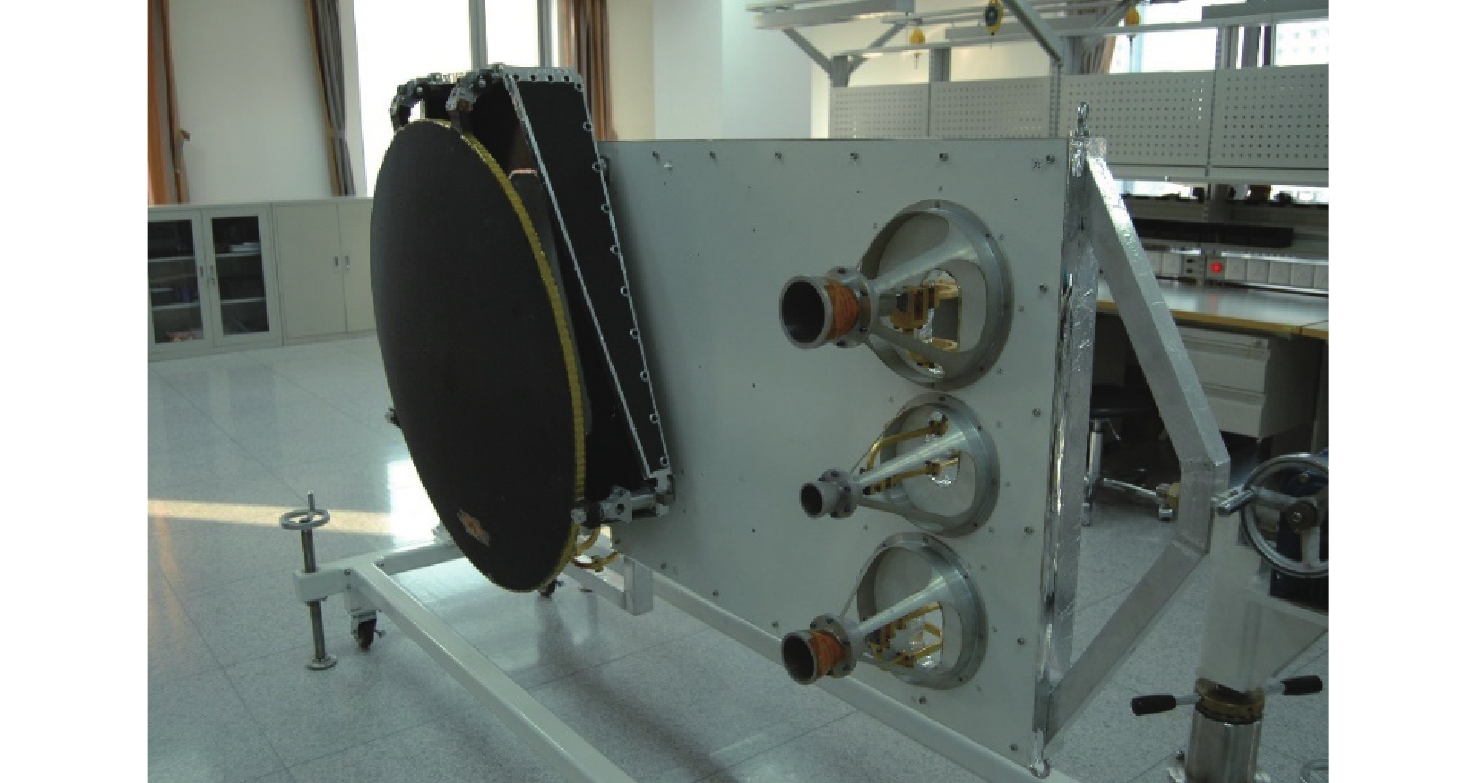
图 7 HY-2校正辐射计的实验室折叠状态(左侧是折叠的反射面天线,右侧是三个定标天线)
Figure 7. Folded state of the HY-2 calibration radiometer (the left side is the folded reflector antenna, and the right side is the three calibration antennas)
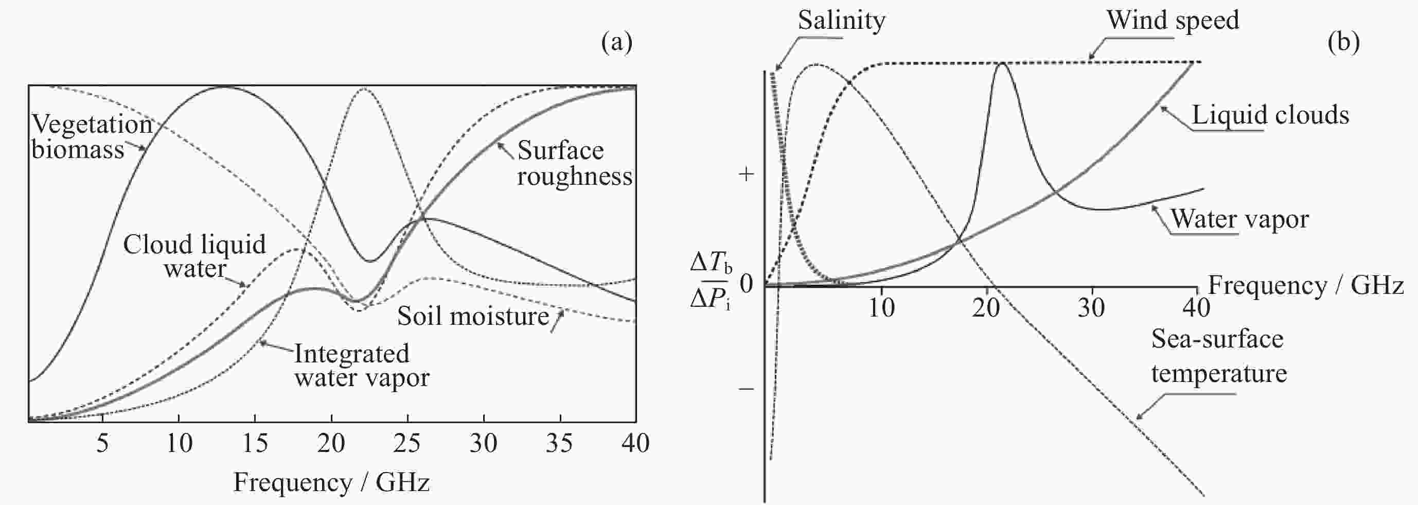
图 8 40 GHz以下陆地表面(a)和海洋表面(b)参数对于亮温的敏感性
Figure 8. Sensitivity of land surface (a) and ocean surface (b) parameters below 40 GHz to brightness temperatures
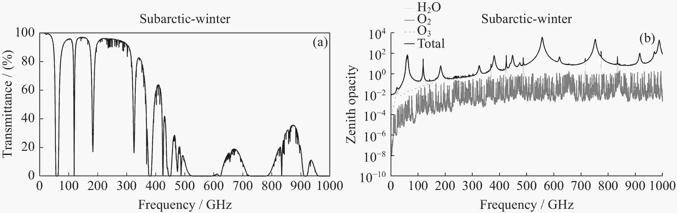
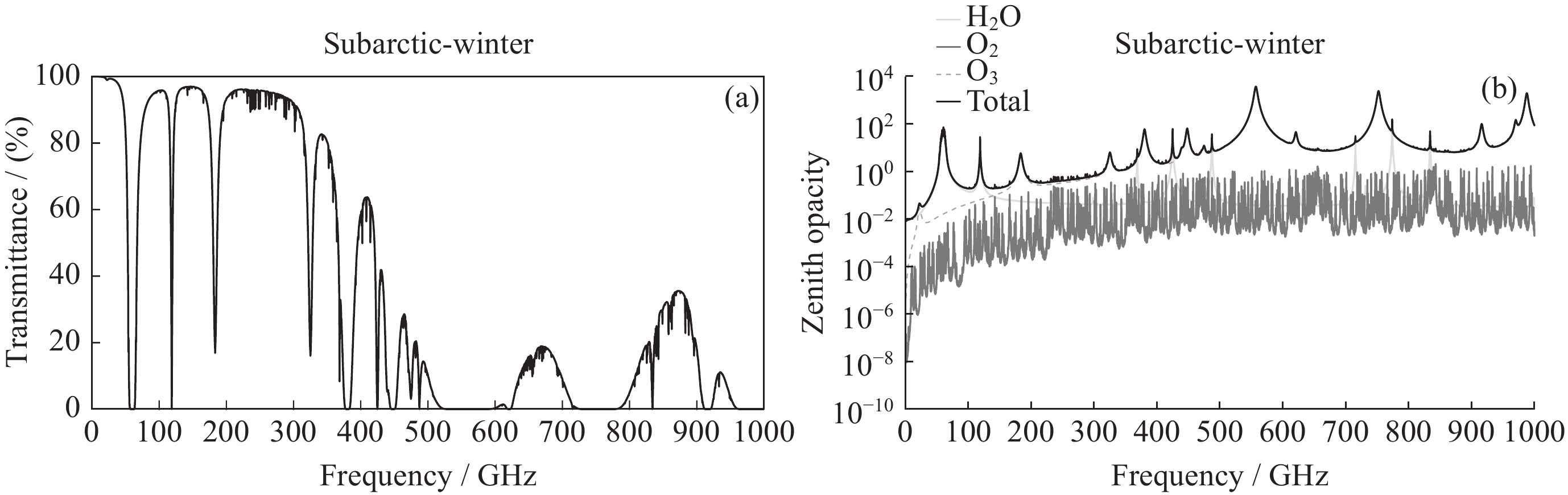
图 9 利用美国空军地球物理实验室提供的亚北极地区冬天廓线计算的透过率(a)和不同大气成分(水汽、氧气、臭氧)的光学厚度(b)
Figure 9. Transmittance (a) and optical depth (b) calculated using a subarctic winter atmosphere profile from ARGL
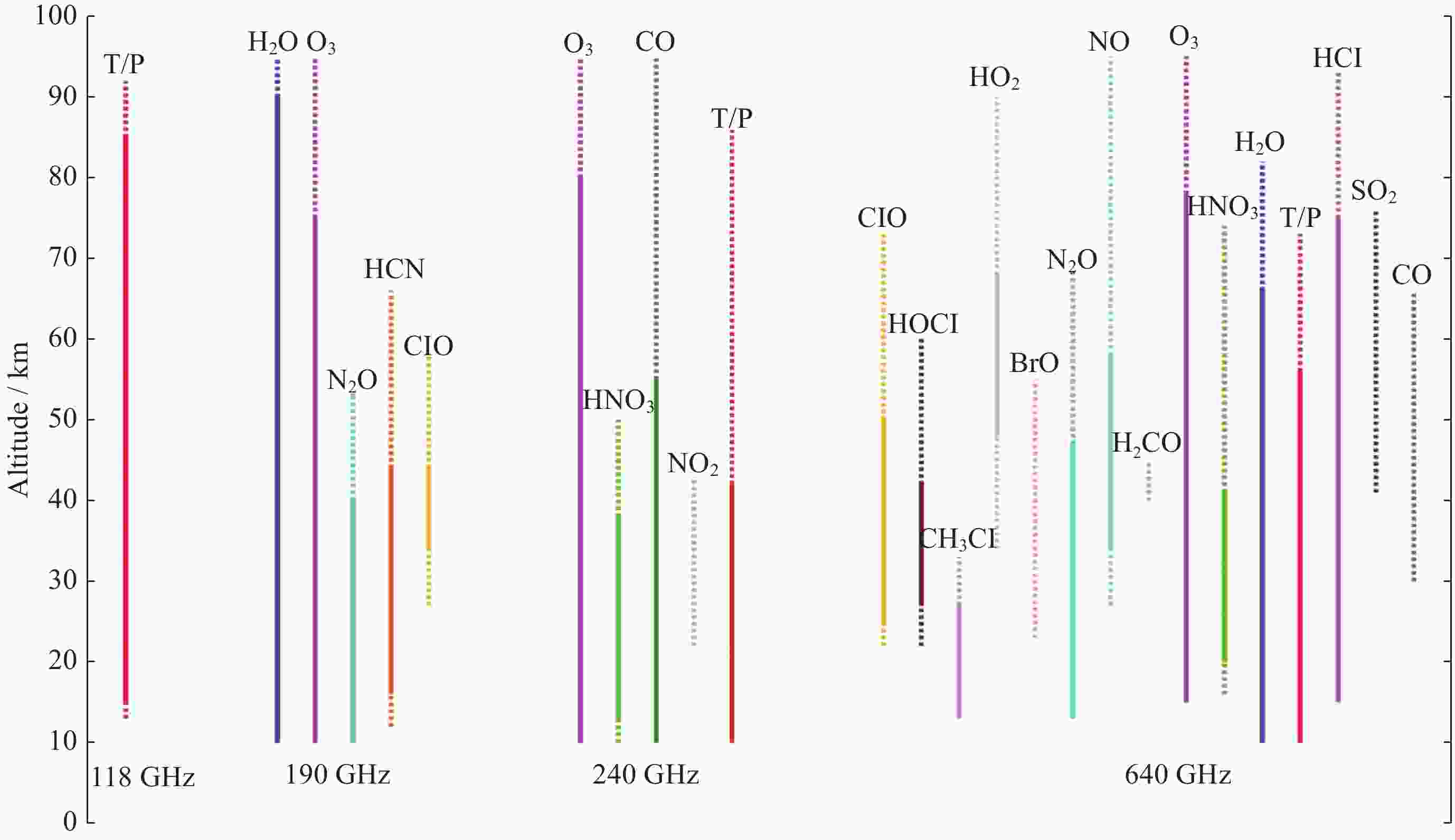
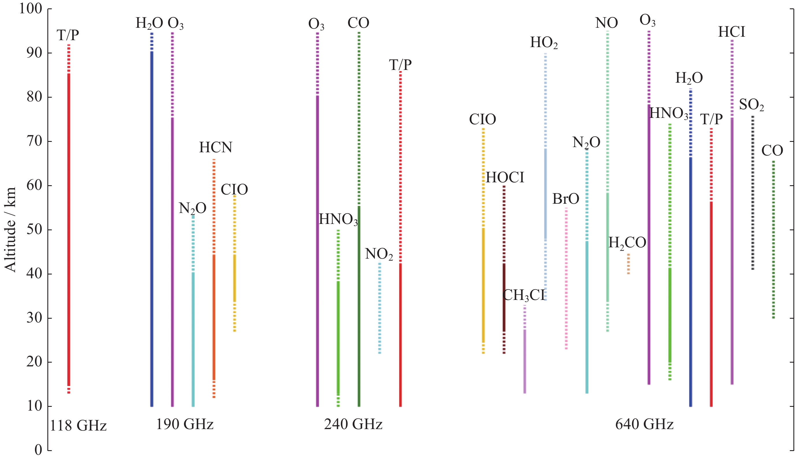
图 11 TALIS可以观测的参数及其高度范围分布
Figure 11. Parameters that may be observed by TALIS and their height range distributions
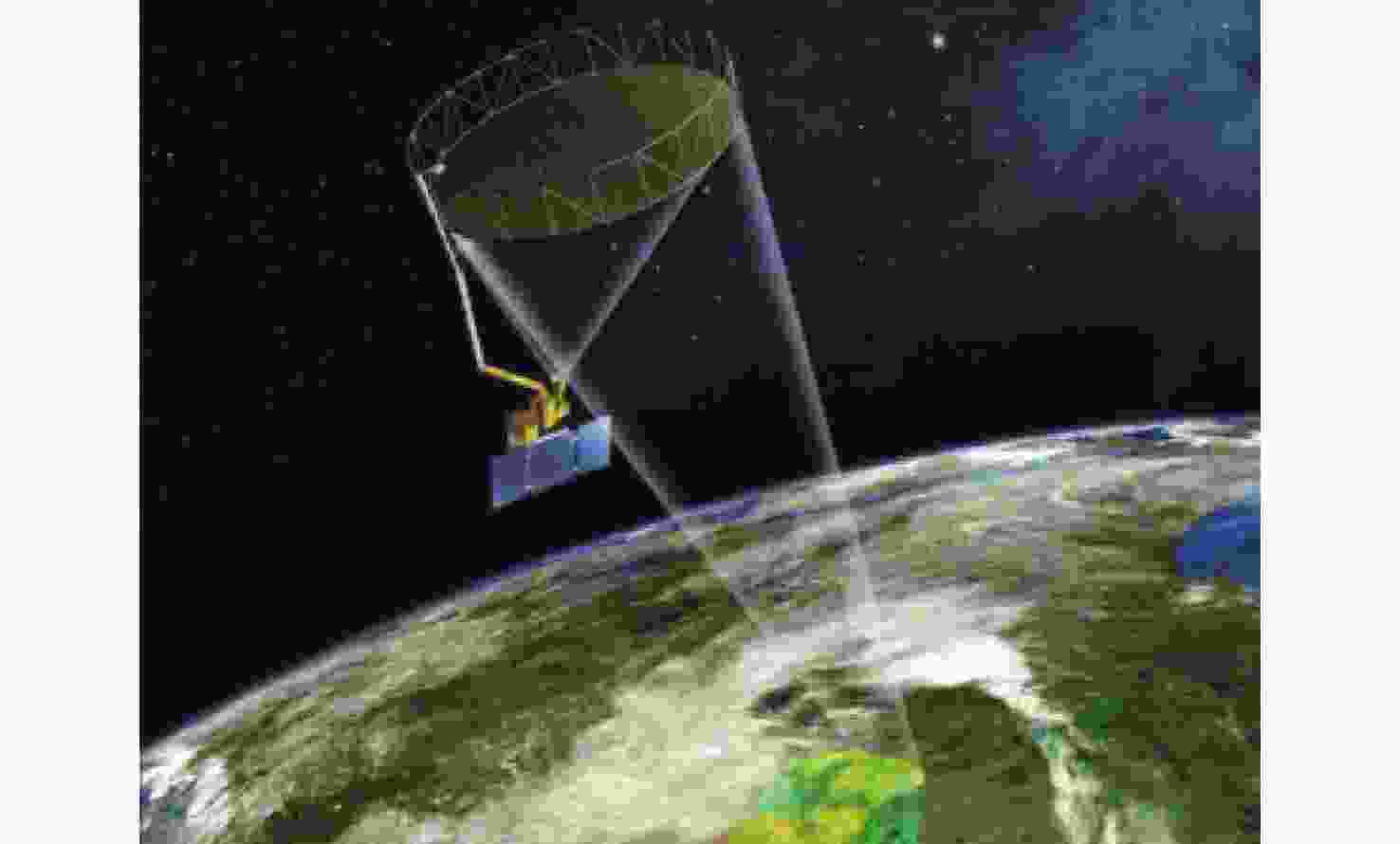
图 12 SMAP卫星观测。6 m轻量可展开网面反射面,雷达和辐射计共用一个馈源,天线和接收机同时旋转实现圆锥扫描
Figure 12. SMAP satellite observation. 6 m lightweight deployable mesh reflector, radar and radiometer share a feed source, the antenna and receiver rotate simultaneously to achieve conical scanning
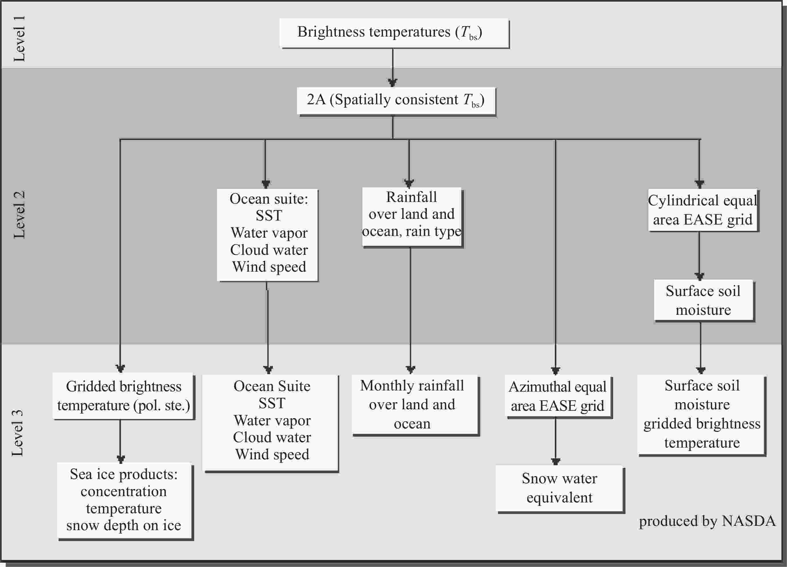
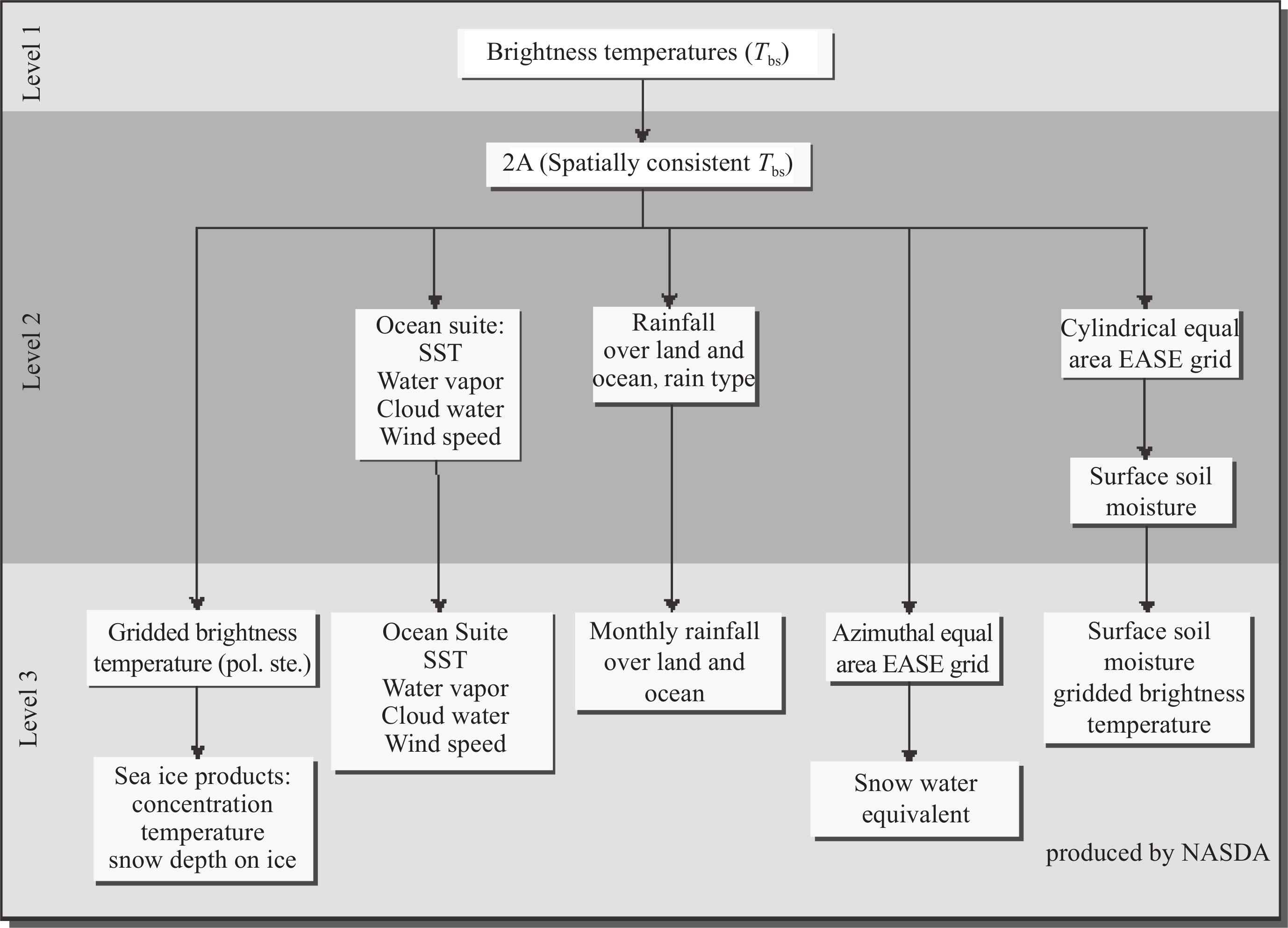
图 14 AMSR标准数据流程(一级数据由仪器研制方NASDA产生)
Figure 14. AMSR standard product flow chart (Level 1 was produced by NASDA)
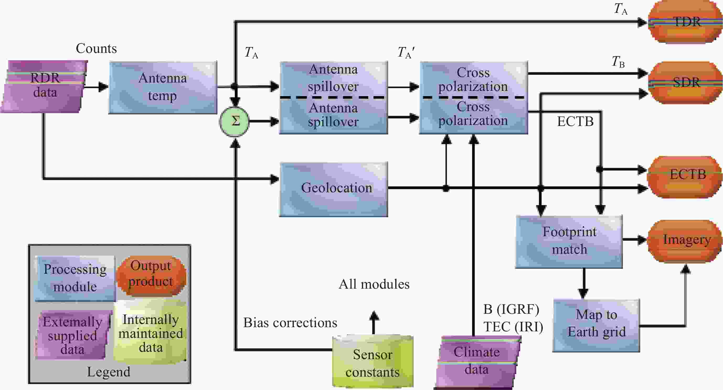
图 15 空间微波数据处理算法流程
Figure 15. Spaceborne microwave radiometer data processing algorithm
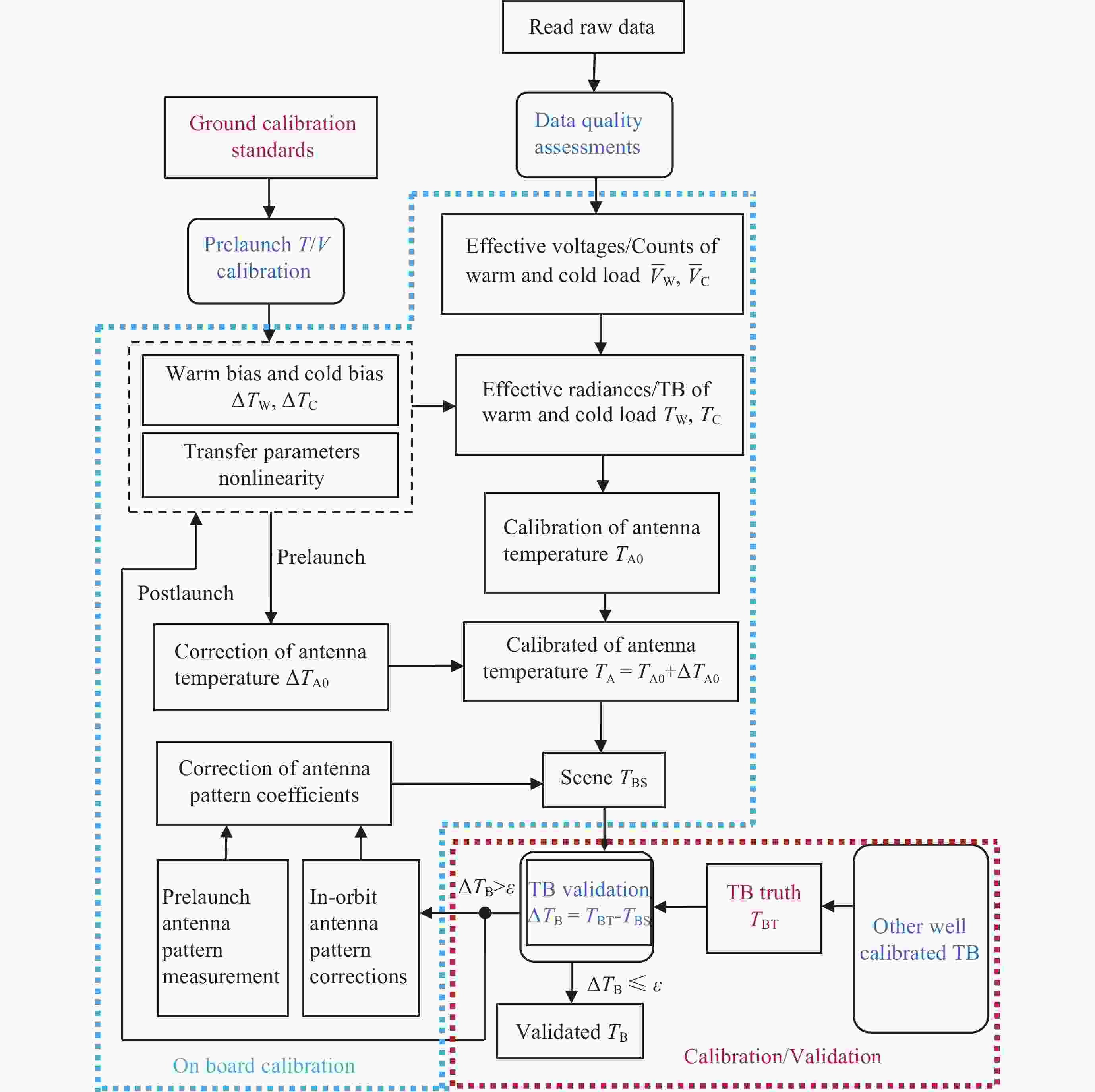
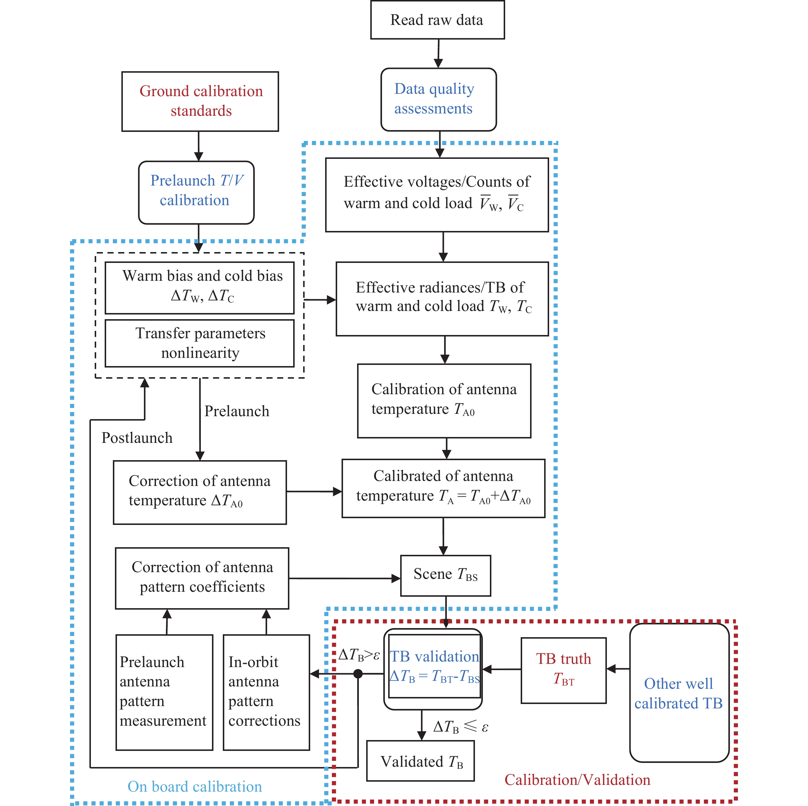
图 16 星载微波辐射计定标总流程
Figure 16. Overall flow chart of calibration of spaceborne microwave radiometer
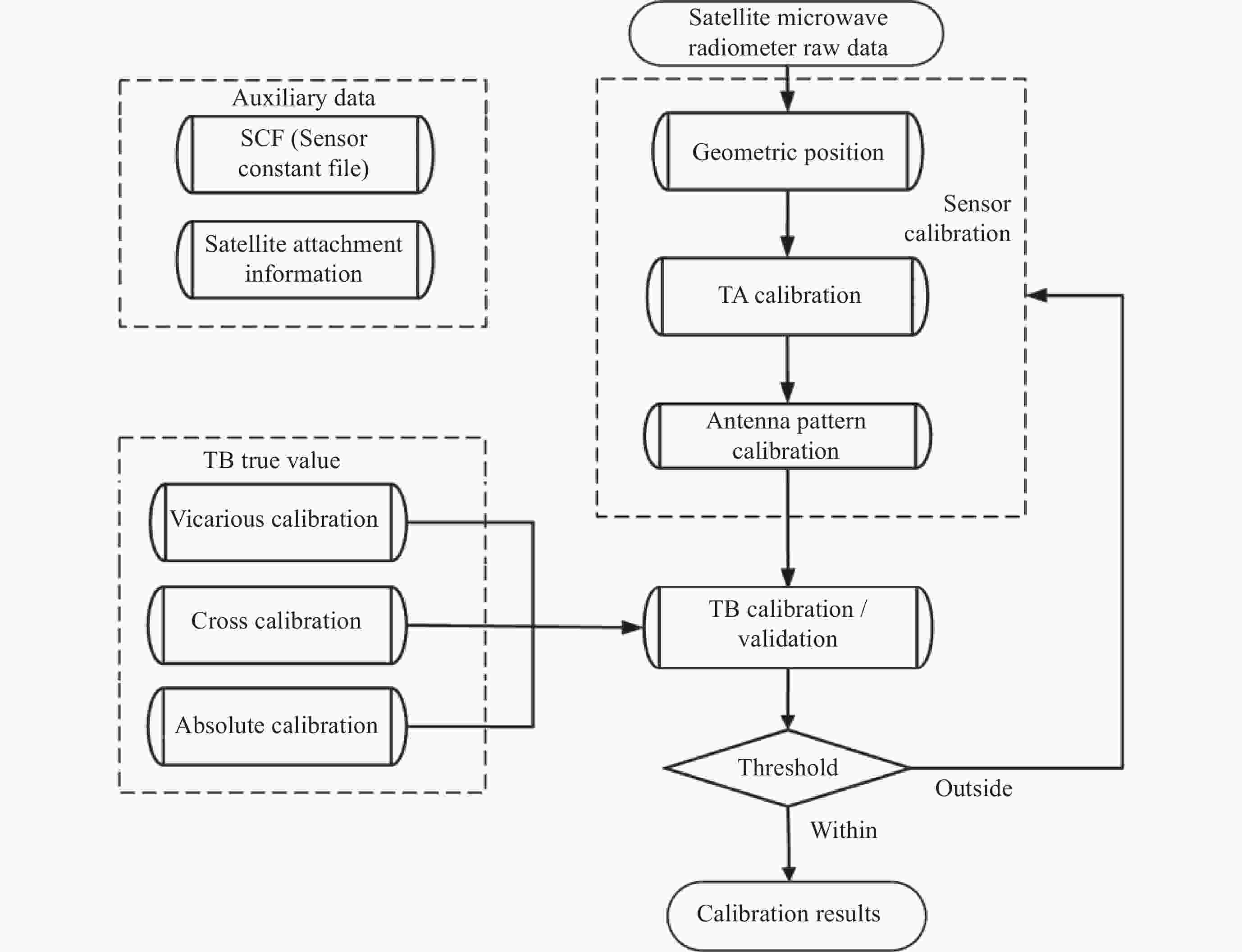
图 17 星载微波辐射计数据定标/检验流程
Figure 17. Spaceborne microwave radiometer data calibration/validation
表 1 美国、欧洲和中国的典型大气微波探测仪的比较
Table 1. Comparison of typical atmospheric microwave sounders in the United States, Europe and China
名称/国家或地区 通道
数量中心频率/GHz 观测范围
(刈幅)/km微波探测仪
(MSU)美国4 50.30, 53.74, 54.96, 57.95 2350 特种微波温度计
(SSM/T)美国7 50.50, 53.20, 54.35, 54.90, 58.40, 58.825, 59.40 1500 特种微波湿度计
(SSM/T-2)美国5 91.655 ± 1.250, 150.0 ± 1.250, 183.31 ± 7.0, 183.31 ± 3.0, 183.31 ± 1.0 1500 先进微波探测仪-A
(AMSU-A)美国15 23.800, 31.400, 50.300, 52.800, 53.596 ± 0.115, 54.400, 54.940, 55.500, f0 = 57.290344, f0 ± 0.217, f0 ± 0.3222 ± 0.048, f0 ± 0.3222 ± 0.022, f0 ± 0.3222 ± 0.010, f0 ± 0.3222 ± 0.0045, 89.000 2250 先进微波探测仪-B
(AMSU-B)美国5 89.0, 150, 183.31 ± 1.00, 183.31 ± 3.00, 190.31 ± 7.00 2250 微波湿度计
(MHS)欧洲5 89,157, 183.31±3, 183.31±1, 190.311 2180 微波温度计-1
(MWTS-1)中国4 50.30, 53.596 ± 0.115, 54.94, 57.290 2200 微波湿度计-1
(MWHS-1)中国5 150 QV, 150 QH, 183.31 ± 7.0, 183.31 ± 3.0, 183.31 ± 1.0 2700 先进微波探测仪
(ATMS)美国22 23.800, 31.400, 50.300, 51.760, 52.800, 53.596 ± 0.115, 54.400, 54.940, 55.500, f0 = 57.290344, f0 ± 0.217, f0 ± 0.3222 ± 0.048, f0 ± 0.3222 ± 0.022, f0 ± 0.3222 ± 0.010, f0 ± 0.3222 ± 0.0045, 88.2, 165.5, 183.31 ± 7.0, 183.31 ± 4.5, 183.31 ± 3.0, 183.31 ± 1.8, 183.31 ± 1.0 2200 微波温度计-2
(MWTS-2)中国13 与ATMS的50~58 GHz的通道相同 2250 微波湿度计-2
(MWHS-2)中国15 89, 118.75±5.0, 118.75±3.0, 118.75±2.5, 118.75±1.1, 118.75±0.8, 118.75±0.3, 118.75±0.2, 118.75±0.08, 150/ 166 (C, D星150 GHz,E星以后166 GHz) , 183±7, 183±4.5, 183±3, 183±1.8, 183±1 2700 微波温度计-3
(MWTS-3)中国17 与AMTS的23.8, 31.4和50~58 GHz通道相同, 此外增加了53.246 ± 0.08和53.948 ± 0.081通道 2700 微波探测仪
(MWS)欧洲24 17个MWTS-3通道, 7个MWHS-2通道(除了118 GHz的8个通道)和229.0通道 2300  下载: 导出CSV
表 2 美国SSMI,SSMIS,TMI,GMI与中国FY-3的MWRI系列微波成像仪比较
Table 2. Comparison of American SSMI, SSMIS, TMI, and GMI with China’s FY-3 MWRI series microwave imagers
载荷 卫星平台 轨道 频率/GHz,极化 天线口径,刈幅
宽度,入射角有效运行
时间(年)SSMI DMSP-F08
DMSP-F10
DMSP-F11
DMSP-F12
DMSP-F13
DMSP-F14
DMSP-F15极轨,850 km太阳同步轨道, 19.35 V,H
22.235 V
37.0 V,H
85.5 V,H61 cm×66 cm,
1400 km,53.1°1987-2006
1990-1997
1991-2000
1994-2008
1995-2015
1997-2020
1999-2020SSMIS DMSP-F16
DMSP-F17
DMSP-F18
DMSP-F19极轨,850 km太阳同步轨道 19.35~183.31 GHz 61 cm×66 cm,
1400 km,53.1°2003-2023
2006-2025
2009-2025
2014-2016TMI美国 TRMM 近赤道轨道,350 km,1997-2001年,半赤道轨道,402 km,2001年 10.65 V,H
19.35 V,H
21.3 V
37.0 V,H
85.5 V,H61 cm×66 cm,
760 km,53°1997-2015 GMI美国 GPM 近赤道407 km轨道,65°倾角 10.65 V,H
18.7 V,H
23.8 V
36.5 V,H
89.0 V,H
165.5 V,H
183.31+/–3 V
183.31+/–7 V120 cm,850 km,
53°2014-2027 MWRI-1 FY-3A
FY-3B
FY-3C
FY-3D极轨,831 km太阳同步轨道,98.75°倾角 5频率10通道:10.65,18.7,23.8,36.5,89 GHz,全部VH极化 90 cm,1400 km,
53.2°2008-2015
2010-2021
2013-2023
2017-2024MWRI-2 FY-3F
FY-3H极轨,831 km太阳同步轨道 13频率22通道:10.65,18.7,23.8,36.5,50.3,52.61,53.24,53.75,89118.7503±3.2,118.7503±2.1,118.7503±1.4,118.7503±1.2。118为V极化,其他为VH极化 180 cm
1400 km
53°/50°2023-2032
2024-2029MWRI-RM FY-3G 407 km圆轨道,50°倾角 17频率26通道:在MWRI-2基础上,增加四个V极化通道:165.5±0.75,183.31±2.0 ,183.31± 3.4,183.31±7.0 GHz 120 cm
800 km
53.1°2023-2032 MWI Metop-SG-A1
Metop-SG-A2
Metop-SG-A383 5 km太阳同步轨道 18频率26通道:18.7~183 GHz 75 cm
1700 km
53.1°2025-2032
2032-3039
2039-2046注 开始时间大于2023年表示计划发射时间及其对应寿命的结束时间;开始时间小于2023年而结束时间大于2023年表示该载 荷目前在轨工作[22]。
下载: 导出CSV
表 3 ICI的主要技术指标
Table 3. ICI’s main specifications
中心频率/GHz 带宽/MHz 灵敏度/K 定标偏差/K 极化方式 瞬时视场/km 183.31±7.0 2×2000 0.8 1.0 V 16 183.31±3.4 2×1500 0.8 1.0 V 16 183.31±2.0 2×1500 0.8 1.0 V 16 243.2±2.5 2×3000 0.7 1.5 V, H 16 325.15±9.5 2×3000 1.2 1.5 V 16 325.15±3.5 2×2400 1.3 1.5 V 16 325.15±1.5 2×1600 1.5 1.5 V 16 448±7.2 2×3000 14 1.5 V 16 448±3.0 2×2000 1.6 1.5 V 16 448±1.4 2×1200 2.0 1.5 V 16 664±4.2 2×5000 1.6 1.5 V, H 16
下载: 导出CSV
表 4 日本AMSR,AMSR-E,ASMR2与中国海洋卫星微波成像仪RM比较
Table 4. Comparison between Japan’s AMSR, AMSR-E, ASMR2 and China’s oceanic satellite microwave imager RM
载荷 卫星平台 天线尺寸/m 有效运行时间
(年/月)频率/GHz,极化 降交点时间(LT) AMSR ADEOS-II 2.0 2003/04-2003/10 6.93 VH,10.65 VH,18.7 VH,23.8 VH,36.5 VH,50.3 V,52.8 V,89.0 VH 22:30 AMSR-E Aqua 1.6 2002/05-2011/10 6.93 VH,10.65 VH,18.7 VH,23.8 VH,36.5 VH,89.0 VH 13:30 ASMR2 GCOM-W1 2.0 2012/05至今 6.93 VH,7.3 VH,10.65 VH,18.7 VH,23.8 VH,36.5 VH,89.0 VH 01:30 RM HY-2A,2B 1.2 2011至今 6.6 VH,10.7 VH,18.7 VH,23.8 V,37 VH 06:00
下载: 导出CSV
表 5 俄罗斯3代微波成像探测仪与美国SSMIS的比较
Table 5. Comparison of 3 Russian Microwave Imaging sounders with the American SSMIS
MTVZA/GHz MTVZA-GY/GHz MTVZA-GY-MP/GHz SSMIS/GHz 瞬时视场
IFOV/km像元
/km极化 - - 6.9 - 135×302 32×2 V, H - 10.6 10.6 - 89×198 32×32 V, H 18.7 18.7 18.7 19.35 52×116 32×32 V, H 22.238 23.8 23.8 22.235 42×94 32×32 V, H(V) 33 31.5 31.5 - 35×76 32×2 V, H 36.5 36.7 36.7 37 30×67 32×32 V, H 42 42 - - 26×60 32×32 V, H 48 48 - 50.3 24×43 32×32 V(H) - - 52.3 52.8 21×48 32×32 V(H) 52.8 52.8 52.8 53.596 21×48 48×48 V(H) 53.3 53.3 53.3 54.4 21×48 48×48 V(H) 53.8 53.8 53.8 55.5 21×48 48×48 V(H) 54.64 54.64 54.64 57.29 21×48 48×48 H(RC) 55.63 55.63 55.63 59.4 21×48 48×48 H(RC) 57.290344±
0.3222±0.157.290344±
0.3222±0.157.290344±
0.3222±0.160.792668±
0.357892±0.05021×48 48×48 H(RC) 57.290344±
0.3222±0.0557.290344±
0.3222±0.0557.290344±
0.3222±0.0560.792668±
0.357892±0.01621×48 48×48 H(RC) 57.290344±
0.3222±0.02557.290344±
0.3222±0.02557.290344±
0.3222±0.02560.792668±
0.357892±0.00621×48 48×48 H(RC) 57.290344±
0.3222±0.0157.290344±
0.3222±0.0157.290344±
0.3222±0.0160.792668±
0.357892±0.00221×48 48×48 H(RC) 57.290344±
0.3222±0.00557.290344±
0.3222±0.00557.290344±
0.3222±0.00560.792668±0.357892 21×48 48×48 H(RC) - - - 63.283248±0.285271 14×30 16×16 (RC) 91.655 91.655 91.655 91.655 9×21 32×32 VH - - - 150±1.25 9×21 32×32 (H) 183.31±7.0 183.31±7.0 183.31±7.0 183.31±6.6 9×21 32×32 V(H) 183.31±3.0 183.31±3.0 183.31±3.0 183.31±3.0 - - V(H) 183.31±1.0 183.31±1.0 183.31±1.0 183.31±1.0 - - V(H)
下载: 导出CSV
表 6 全极化微波辐射计的比较
Table 6. Comparison of fully polarized microwave radiometers
载荷 天线尺寸/m 发射时间 频率/GHz:极化方式 轨道 WindSat 1.83 2003 6.8,23.8:V,H;
10.65,18.7,37.0:V,H,P,M,L,R极轨 FPMR 1.8 2016 6.8,23.8:V,H;
10.65,19.35:T3,T4
37.0:V,H,P,M,L,R极轨 COWVR 0.75(小卫星) 2022 10.65,18.7,33.9:V,H,P,M,L,R 51.6°倾角中低轨 MWI WSF-M 1.8 2024 23.8,37.3,89:V,H
10.85,18.85,36.75:V,H,T3,T4极轨 CIMR 7.0 2028 1.4135,6.875,10.65,18.7,36.5:
V,H,P,M,L,R极轨
下载: 导出CSV
表 7 微波波段的名称及频率范围
Table 7. Microwave band name and frequency range
名称 频率范围
/GHz名称 频率范围
/GHzP波段 0.3~1 Q波段 30~50 L波段 1~2 U波段 40~60 S波段 2~4 V波段 50~75 C波段 4~8 E波段 60~90 X波段 8~12 W波段 75~110 Ku波段 12~18 F波段 90~140 K波段 18~27 G波段 140~220 Ka波段 37~40 R波段 220~325
下载: 导出CSV
表 8 国际电联ITU推荐的被动微波遥感通道
Table 8. Passive microwave remote sensing channels recommended by ITU
频段/GHz 带宽需求/MHz 谱线或中心频率/GHz 测量参数 扫描方式 1.37~1.4 s, 1.4~1.427 P 100 1.4 土壤湿度、海洋盐度、海面温度、
植被指数N 2.64~2.65 s, 2.655~2.69 s, 2.69~2.7 P 45 2.7 土壤湿度、海洋盐度、植被指数 N 4.2~4.4 s, 4.95~4.99 s 200 4.3 海面温度 N 6.425~7.25 200 6.85 海面温度 N 10.6~10.68 p, 10.68~10.7 P 100 10.65 雨率、雪水当量、冰形态、海况、
海面风N 15.2~15.35 s, 15.35~15.4 P 200 15.3 水汽、雨率 N 18.6~18.8 p 200 18.7 雨率、海况、海冰、水汽、海面风、
土壤发射率和湿度N 21.2~21.4 p 200 21.3 水汽、液水 N 22.21~22.5 p 300 22.235 水汽、液水 N 23.6~24 P 400 23.8 水汽、液水、大气探测相关通道 N 31.3~31.5 P, 31.5~31.8 p 500 31.4 海冰、水汽、溢油、云、液水、表面温度、50~60 GHz的参考窗区通道 N 36~37 p 1000 36.5 雨率、雪、海冰、云 N 50.2~50.4 P 200 50.3 大气温度廓线的参考窗区通道
(表面温度)N 52.6~54.25 P, 54.25~59.3 p 6700 多个频点 大气温度廓线(氧气吸收线) N 86~92 P 6000 89 云、溢油、冰、雪、雨、118 GHz附近温度探测的参考窗区 N 100~102 P 2000 100.49 N2O, NO L 109.5~111.8 P 2000 110.8 O3 L 114.25~116 P 1750 115.27 CO L 115.25~116 P, 116~122.25 p 7000 118.75 大气温度廓线(氧气吸收线) 148.5~151.5 P 3000 150.74 N2O、地表温度、云参数、
温度探测的参考窗区N, L 155.5~158.5 p 3000 157 地表和云参数 N 164~167 P 3000 164.38, 167.2 N2O、云水和冰、雨、CO、ClO N, L 174.8~182 p, 182~185 P, 185~190 p, 190~191.8 P 17000 175.86, 177.26, 183.31, 184.75 N2O、水汽廓线、O3 N, L 200~209 P 9000 200.98, 203.4, 204.35,
206.13, 208.64N2O、ClO、水汽、O3 L 226~231.5 P 5500 226.09, 230.54, 231.28 云、湿度、N2O(226.09), CO(230.54), O3(231.28), 参考窗区 N, L 235~238 p 3000 235.71, 237.15 O3 L 250~252 P 2000 251.21 N2O L 275~277 2000 276.33 NO, N2O(276.33) L 294~306 12000 301.44 NO, N2O(301.44), O3, O2, HNO3, HOCl N, L 316~334 18000 325.15 水汽廓线(325.15), O3, HOCl N, L 342~349 7000 345.8, 346 CO(345.8), HNO3, CH3Cl, O3, O2, HOCl N, L 363~365 2000 364.32 O3 L 371~389 18000 380.2 水汽廓线 N 416~434 18000 425 温度廓线 N 442~444 2000 443 H2O, O3, HNO3, N2O, CO N, L 496~506 10000 498.1, 498.2, 498.3, 498.4, 498.5, 498.6 O3, CH3Cl, N2O, BrO, ClO,
水汽廓线N, L 546~568 22000 557 水汽廓线 N, L 624~629 5000 624.27, 624.34, 624.77,
625.37, 625.92, 627.18,
627.77, 628.46HCl, BrO, O3, HCl, SO2, H2O2 L 634~654 20000 635.87, 642.85, 647.2,
649.45, 649.7, 650.28,
650.73, 651.77, 652.83CH3Cl, HOCl, ClO,
水汽, N2O, BrO, O3N, L 659~661 2000 660.49 BrO L 684~692 8000 688 ClO, CO, CH3Cl L 730~732 2000 731 O2, HNO3 L 851~853 2000 852 NO L 951~956 5000 952, 955 O2, NO L 注 P表示首选频段,只能与被动服务共用;p也表示首选频段,但是可以与主动服务共用;s表示次要分配频段。N表示天底观测, L表示临边观测。
下载: 导出CSV
表 9 已经完成的星载THz辐射计卫星
Table 9. Completed spaceborne THz radiometer satellites
载荷/平台
名称发射时间 国家/机构 科学目标 频段/GHz 备注 UARS-MLS 1991 NASA 地球 63,183,205 第一个超外差接收机,高分辨率平流层成分光谱仪 SWAS 1998 NASA 天文学 490,550 第一台亚毫米波超外差仪器:水、氧气和CO Odin 2001 瑞典 天文学和地球 118,490~500,
540~580使用斯特林制冷的超外差空间/地球探测仪 MIRO 2004 ESA 彗星 188,560 第一个亚毫米波行星探测卫星,超外差接收机,测量水、CO、NH3和CH3OH Aura-MLS 2004 NASA 地球 118,190,240,
640,2520第一个THz超外差任务:臭氧和气候变化 Herschel 2009 ESA 天文学 480~1900,
1500~5000超外差和直接检波接收机,制冷望远镜,多台仪器 Planck 2009 ESA 天文学 30~70,100~850 高低频率探测宇宙背景 SMILES 2009 日本 地球 625~650 第一台超导超外差接收机的地球观测
下载: 导出CSV
表 10 地球大气临边探测仪指标对比
Table 10. Comparison of specifications of spaceborne limb detectors of the Earth
临边探
测仪探测
频率/GHz系统噪声
温度/K频谱仪
带宽/MHz频谱
分辨率/MHz积分
时间/s扫描
范围/km垂直
分辨率/kmAura/MLS 118, 190, 240, 640, 2500 1200, 900~1100, 1200~1600, 4000~4400, 11000~18000 1300, 190, 10, 500 6~96, 6~32, 0.15, 500 0.16 2~60 1.5~6 JEM/SMILES 625, 650 < 700 1200 1.4 0.5 10~60 3.5~4.1 SIW 655 1000~1200 8000 1 0.5 10~90 5 SMILES-2 638, 763, 1830, 2060 150, 180, 990, 990 8000, 6000, 1000, 1000 0.5 0.25 20~200 1.9
下载: 导出CSV
表 11 AMSR/AMSR-E的标准数据定义
Table 11. Standard product definition for AMSR/AMSR-E
名称 定义 L1 A 测量的工程量,即仪器输出电压,或者数码值。同时还包括可供高级数据产生的必要信息,包括卫星姿态和仪器条件。数据不是图像形式,但是以刈幅格式存储 L1 B 测量的亮温。同时包括地理位置和数据质量信息。数据不是图像形式,但是以刈幅格式存储。也可以给出图形数据 L2 空间分辨率一致的重采样亮温数据和由反演算法反演的地物参数。同时包括地理位置和数据质量信息。数据不是图像形式,但是以刈幅格式存储。也可以给出图形数据 L3 投影在全球网格上的、时间和空间平均的地物参数值。对于AMSR/AMSR-E,产生亮温和地物参数的日平均和月平均全球网格图像
下载: 导出CSV
-
[1] ULABY F T, LONG D G. Microwave Radar and Radiometric Remote Sensing[M]. Ann Arbor: University of Michigan Press, 2014 [2] URBAN J, BARON P, LAUTIÉ N, et al. MOLIERE (v5): a versatile forward- and inversion model for the millimeter and sub-millimeter wavelength range[J]. Journal of Quantitative Spectroscopy and Radiative Transfer, 2004, 83(3/4): 529-554 [3] JAXA. ADEOS-II Data Users Handbook [M]. 3rd ed., 2006. https://www.eorc.jaxa.jp/AMSR/eorc/en/hatoyama/adeos2/adeos2_handbook_e.pdf [4] 王振占, 张德海, 赵谨, 等. HY-2A卫星大气校正微波辐射计在轨数据定标和检验研究[J]. 中国工程科学, 2013, 15(7): 44-52,61 doi: 10.3969/j.issn.1009-1742.2013.07.007WANG Zhenzhan, ZHANG Dehai, ZHAO Jin, et al. In-orbit calibration and validation of atmospheric correction microwave radiometer on HY-2A satellite[J]. Strategic Study of CAE, 2013, 15(7): 44-52,61 doi: 10.3969/j.issn.1009-1742.2013.07.007 [5] BERGER M, CAMPS A, FONT J, et al. Measuring ocean salinity with ESA’s SMOS mission – Advancing the science[J]. ESA Bulletin, 2002, 111: 113-121 [6] YIN X B, BOUTIN J, SPURGEON P. First assessment of SMOS data over open ocean: Part I – pacific ocean[J]. IEEE Transactions on Geoscience and Remote Sensing, 2012, 50(5): 1648-1661 doi: 10.1109/TGRS.2012.2188407 [7] LAGERLOEF G, COLOMB F R, LE VINE D, et al. The Aquarius/SAC-D mission: designed to meet the salinity remote-sensing challenge[J]. Oceanography, 2008, 21(1): 68-81 doi: 10.5670/oceanog.2008.68 [8] GLOERSEN P, BARATH F. A scanning multichannel microwave radiometer for Nimbus-G and SeaSat-A[J]. IEEE Journal of Oceanic Engineering, 1977, 2(2): 172-178 doi: 10.1109/JOE.1977.1145331 [9] WILHEIT T T, CHANG A T C. An algorithm for retrieval of ocean surface and atmospheric parameters from the observations of the scanning multichannel microwave radiometer[J]. Radio Science, 1980, 15(3): 525-544 doi: 10.1029/RS015i003p00525 [10] MO T, GOLDBERG M D, CROSBY D S, et al. Recalibration of the NOAA microwave sounding unit[J]. Journal of Geophysical Research:Atmospheres, 2001, 106(D10): 10145-10150 doi: 10.1029/2001JD900027 [11] MO T. Prelaunch calibration of the advanced microwave sounding unit-A for NOAA-K[J]. IEEE Transactions on Microwave Theory and Techniques, 1996, 44(8): 1460-1469 doi: 10.1109/22.536029 [12] MO T. AMSU-A antenna pattern corrections[J]. IEEE Transactions on Geoscience and Remote Sensing, 1999, 37(1): 103-112 doi: 10.1109/36.739131 [13] LAMBRIGTSEN B. AIRS Project Algorithm Theoretical Basis Document: Level 1b, Part 3: Microwave Instruments[R]. Pasadena: JET Propulsion Laboratory California Institute of Technology, 2000 [14] GOODRUM G, KATHERINE B. Kidwell and Wayne Winston[R]. NOAA KLM User’s Guide, 2000 [15] SAUNDERS R W, HEWISON T J, STRINGER S J, et al. The radiometric characterization of AMSU-B[J]. IEEE Transactions on Microwave Theory and Techniques, 1995, 43(4): 760-771 doi: 10.1109/22.375222 [16] OLSEN E T. AIRS/AMSU/HSB Version 4.0 Data Release User Guide, Version 1.1[R]. Pasadena: JET Propulsion Laboratory California Institute of Technology, 2005 [17] 王振占, 李芸. 神舟四号飞船微波辐射计定标和检验(Ⅰ)——微波辐射计外定标[J]. 遥感学报, 2004, 8(5): 397-403WANG Zhenzhan, LI Yun. Calibration and validation of microwave radiometer (RAD) on-aboard SZ-4 spacecraft: Part I RAD external calibration[J]. Journal of Remote Sensing, 2004, 8(5): 397-403 [18] 谷松岩, 王振占, 马刚, 等. 气象卫星微波大气遥感[M]. 北京: 科学出版社, 2021GU Songyan, WANG Zhenzhan, MA Gang, et al. Microwave Remote Sensing on Metrological Satellite[M]. Beijing: Science Press, 2021 [19] JIANG X W, LIN M S, LIU J Q, et al. The HY-2 satellite and its preliminary assessment[J]. International Journal of Digital Earth, 2012, 5(3): 266-281 doi: 10.1080/17538947.2012.658685 [20] 林明森, 何贤强, 贾永君, 等. 中国海洋卫星遥感技术进展[J]. 海洋学报, 2019, 41(10): 99-112LIN Mingsen, HE Xianqiang, JIA Yongjun, et al. Advances in marine satellite remote sensing technology in China[J]. Haiyang Xuebao, 2019, 41(10): 99-112 [21] 张庆君. 面向碳综合治理的卫星海洋遥感体系展望[J]. 前瞻科技, 2022, 1(1): 126-145ZHANG Qingjun. Prospect of satellite ocean remote sensing system for comprehensive carbon management[J]. Science and Technology Foresight, 2022, 1(1): 126-145 [22] OSCAR. Observing Systems Capability Analysis and Review Tool[OL]. [2023-09-18]. https://space.oscar.wmo.int/satellites [23] WENG F Z, ZOU X L, SUN N H, et al. Calibration of Suomi national polar-orbiting partnership advanced technology microwave sounder[J]. Journal of Geophysical Research: Atmospheres, 2013, 118(19): 11187-111200 [24] WENG F Z, YANG H, ZOU X L. On convertibility from antenna to sensor brightness temperature for ATMS[J]. IEEE Geoscience and Remote Sensing Letters, 2013, 10(4): 771-775 doi: 10.1109/LGRS.2012.2223193 [25] GHRC. Defense Meteorological Satellite Program (DMSP) Satellite F13 Source/Platform[OL]. [2023-09-18]. https://ghrc.nsstc.nasa.gov/uso/source_docs/dmsp_f13.html [26] PAGANO T S, CHAHINE M T, AUMANN H H, et al. AIRS/AMSU/HSB on EOS Aqua: first-year post-launch assessment[C]//Proceedings of SPIE 5151, Earth Observing Systems VIII. San Diego: SPIE, 2003 [27] 王振占, 徐曦煜, 李东, 等. 卫星微波遥感技术新进展. 《2019高技术发展报告》第三章“航天技术新进展”3.4节[M]. 北京: 科学出版社, 2019WANG Zhenzhan, XU Xiyu, LI Dong, et al. New Progress on Satellite Microwave Remote Sensing. Section 3.4 New Progress in Space Technology, 2019 High-Tech Development Report[M]. Beijing: Science Press, 2019 [28] EUMETSAT and the National Oceanic and Atmospheric Administration (NOAA) of the United States today signed an agreement on their Joint Polar System (JPS), which will provide observations from two complementary polar orbits in the period from 2020 to 2040 [OL]. (2015-12-02)[2023-11-24]. https://www.eumetsat.int/eumetsat-and-noaa-sign-agreement-joint-polar-system [29] KANGAS V, D'ADDIO S, BETTO M, et al. Metop second generation microwave sounding and microwave imaging missions[C]//Proceedings of the 2012 EUMETSAT Meteorological Satellite Conference. Sopot, Poland, 2012 [30] TENNANT G, SYKES G, BUCKLEY M, et al. Microwave sounder for MetOp-SG[C]//Proceedings of the Advanced RF Sensors and Remote Sensing Instruments & Ka-Band Earth Observation Radar Missions. Noordwijk, The Netherlands: ESA/ESTEC, 2014 [31] ZHANG C, LIU H, WU J, et al. Imaging analysis and first results of the geostationary interferometric microwave sounder demonstrator[J]. IEEE Transactions on Geoscience and Remote Sensing, 2015, 53(1): 207-218 doi: 10.1109/TGRS.2014.2320983 [32] KUNKEE D B, POE G A, BOUCHER D J, et al. Design and evaluation of the first special sensor microwave imager/sounder[J]. IEEE Transactions on Geoscience and Remote Sensing, 2008, 46(4): 863-883 doi: 10.1109/TGRS.2008.917980 [33] SUN N H, WENG F Z. Evaluation of special sensor microwave imager/sounder (SSMIS) environmental data records[J]. IEEE Transactions on Geoscience and Remote Sensing, 2008, 46(4): 1006-1016 doi: 10.1109/TGRS.2008.917368 [34] KUMMEROW C, BARNES W, KOZU T, et al. The tropical rainfall measuring mission (TRMM) sensor package[J]. Journal of Atmospheric and Oceanic Technology, 1998, 15(3): 809-817 doi: 10.1175/1520-0426(1998)015<0809:TTRMMT>2.0.CO;2 [35] SMITH E, ASRAR G, FURUHAMA Y, et al. International Global Precipitation Measurement (GPM) program and mission: an overview[M]//LEVIZZANI V, BAUER P, TURK F J. Measuring Precipitation From Space. Dordrecht: Springer, 2007: 611-653 [36] MEISSNER T, FRANK W. GMI Calibration Algorithm and Analysis Theoretical Basis Document[R]//, 2010 [37] PICA G, ALBERTI G, MEMOLI A, et al. MetOp Second Generation: a joint ESA/EUMETSAT mission for weather forecast and climate monitoring with an imaging radiometer[C]//Proceedings of the 63rd IAC (International Astronautical Congress). Naples, Italy, 2012 [38] D’ADDIO S, KANGAS V, KLEIN U, et al. Microwave imager instrument for MetOp second generation[C]//Proceedings of the 13th Specialist Meeting on Microwave Radiometry and Remote Sensing of the Environment. Pasadena: IEEE, 2014 [39] CREWELL S, BÜHLER S, PRIGENT C. Potential of the Ice Cloud Imaging Instrument within the EUMETSAT Polar System–Second Generation[OL]. [2023-11-24]. https://www-cdn.eumetsat.int/files/2020-04/pdf_peps_ucw3_19.pdf [40] SOLA R G, PUJADES M B, LABRIOLA M, et al. The Ice Cloud Imager for Metop-SG: the development challenge has started[C]//Proceedings of the Advanced RF Sensors and Remote Sensing Instruments & Ka-band Earth Observation Radar Missions. Noordwijk, The Netherlands, 2014 [41] WENTZ F J, MEISSNER T. AMSR Ocean Algorithm, Algorithm Theoretical Basis Document[R]. Greenbelt: National Aeronautics and Space Administration, 2000 [42] OVERVIEW OF THE GLOBAL CHANGE OBSERVATION MISSION (GCOM) [OL]. [2023-11-24]. https://earth.jaxa.jp/files/research/ra/1st_ra_eo/material/material_j.pdf [43] 蒋兴伟, 林明森, 张有广. 中国海洋卫星及应用进展[J]. 遥感学报, 2016, 20(5): 1185-1198JIANG Xingwei, LIN Mingsen, ZHANG Youguang. Progress and prospect of Chinese ocean satellites[J]. Journal of Remote Sensing, 2016, 20(5): 1185-1198 [44] LIU H, ZHU D, NIU L J, et al. MICAP (Microwave imager combined active and passive): a new instrument for Chinese ocean salinity satellite[C]//Proceedings of 2015 IEEE International Geoscience and Remote Sensing Symposium. Milan: IEEE, 2015 [45] RUF C S, KEIHM S J, JANSSEN M A. TOPEX/Poseidon Microwave Radiometer (TMR). I. Instrument description and antenna temperature calibration[J]. IEEE Transactions on Geoscience and Remote Sensing, 1995, 33(1): 125-137 doi: 10.1109/36.368215 [46] BROWN S, RUF C, KEIHM S, et al. Preliminary validation and performance of the Jason microwave radiometer[C]//Proceedings of the IGARSS 2003. 2003 IEEE International Geoscience and Remote Sensing Symposium. Proceedings. Toulouse: IEEE, 2003 [47] BROWN S. Maintaining the long-term calibration of the jason-2/OSTM advanced microwave radiometer through intersatellite calibration[J]. IEEE Transactions on Geo science and Remote Sensing, 2013, 51(3): 1531-1543 doi: 10.1109/TGRS.2012.2213262 [48] FRERY M L, SIMÉON M, GOLDSTEIN C, et al. Sentinel-3 microwave radiometers: instrument description, calibration and geophysical products performances[J]. Remote Sensing, 2020, 12(16): 2590 doi: 10.3390/rs12162590 [49] KERR Y H, WALDTEUFEL P, WIGNERON J P, et al. The SMOS mission: new tool for monitoring key elements of the global water cycle[J]. Proceedings of the IEEE, 2010, 98(5): 666-687 doi: 10.1109/JPROC.2010.2043032 [50] GAISER P W, GERMAIN K M S, TWAROG E M, et al. The WindSat spaceborne polarimetric microwave radiometer: sensor description and early orbit performance[J]. IEEE Transactions on Geoscience and Remote Sensing, 2004, 42(11): 2347-2361 doi: 10.1109/TGRS.2004.836867 [51] BROWN S, FOCARDI P, KITIYAKARA A, et al. The Compact Ocean Wind Vector Radiometer: A New Class of Low-cost Conically Scanning Satellite Microwave Radiometer System[OL]. https://ams.confex.com/ams/94Annual/webprogram/Manuscript/Paper241605/COWVR_2014_AMS_extended_abstract.pdf [52] MAIWALD F, MONTES O, PADMANABHAN S, et al. RF and electronics design of the compact ocean wind vector radiometer[J]. IEEE Journal of Selected Topics in Applied Earth Observations and Remote Sensing, 2020, 13: 3816-3823 doi: 10.1109/JSTARS.2020.3005041 [53] NEWELL D, DRAPER D, REMUND Q, et al. Weather Satellite Follow-on-Microwave (WSF-M) Design and Predicted Performance[OL]. https://ams.confex.com/ams/2020Annual/webprogram/Manuscript/Paper369912/WSFM%20AMS%20Final.pdf [54] VANIN F, LABERINTI P, DONLON C, et al. Copernicus imaging microwave radiometer (CIMR): system aspects and technological challenges[C]//Proceedings of the IGARSS 2020-2020 IEEE International Geoscience and Remote Sensing Symposium. Waikoloa: IEEE, 2020 [55] National Academies of Sciences, Engineering, and Medicine. Handbook of Frequency Allocations and Spectrum Protection for Scientific Uses[M]. 2nd ed. Washington, DC: The National Academies Press, 2015 [56] WENG F Z, YU X W, DUAN Y H, et al. Advanced radiative transfer modeling system (ARMS): a new-generation satellite observation operator developed for numerical weather prediction and remote sensing applications[J]. Advances in Atmospheric Sciences, 2020, 37(2): 131-136 doi: 10.1007/s00376-019-9170-2 [57] 王雪影. 面向星载被动微波辐射计AMSR2 观测像元的自适应陆表发射率模型研究[D]. 北京: 中国科学院大学(中国科学院国家空间科学中心), 2023WANG Xueying. Adaptive microwave land surface emissivity model for observation pixels of spaceborne passive microwave radiometer AMSR2[D]. Beijing: University of Chinese Academy of Sciences (National Space Science Center, the Chinese Academy of Sciences), 2023 [58] NOROUZI H, TEMIMI M, ROSSOW W B, et al. The sensitivity of land emissivity estimates from AMSR-E at C and X bands to surface properties[J]. Hydrology and Earth System Sciences, 2011, 15(11): 3577-3589 doi: 10.5194/hess-15-3577-2011 [59] PELLARIN T, WIGNERON J P, CALVET J C, et al. Two-year global simulation of L-band brightness temperatures over land[J]. IEEE Transactions on Geoscience and Remote Sensing, 2003, 41(9): 2135-2139 doi: 10.1109/TGRS.2003.815417 [60] NJOKU E G, LI L. Retrieval of land surface parameters using passive microwave measurements at 6-18 GHz[J]. IEEE Transactions on Geoscience and Remote Sensing, 1999, 37(1): 79-93 doi: 10.1109/36.739125 [61] ITU. Recommendation ITU-R RS. 515-4 Frequency Bands and Bandwidths Used for Satellite Passive Sensing[R]. Geneva: ITU, 2011 [62] WU D L, YEE J H, SCHLECHT E, et al. THz limb sounder (TLS) for lower thermospheric wind, oxygen density, and temperature[J]. Journal of Geophysical Research:Space Physics, 2016, 121(7): 7301-7315 doi: 10.1002/2015JA022314 [63] JEZEK K C, JOHNSON J T, TAN S R, et al. 500–2000-MHz brightness temperature spectra of the northwestern Greenland ice sheet[J]. IEEE Transactions on Geoscience and Remote Sensing, 2018, 56(3): 1485-1496 doi: 10.1109/TGRS.2017.2764381 [64] 王文煜. 太赫兹大气临边探测辐射计应用仿真研究[D]. 北京: 中国科学院大学(中国科学院国家空间科学中心), 2020WANG Wenyu. Simulation Study on Application for THZ Atmospheric Limb Sounder[D]. Beijing: National Space Science Center, Chinese Academy of Sciences, 2020 [65] BARATH F T, CHAVEZ M C, COFIELD R E, et al. The Upper Atmosphere Research Satellite microwave limb sounder instrument[J]. Journal of Geophysical Research: Atmospheres, 1993, 98(D6): 10751-10762 doi: 10.1029/93JD00798 [66] MURTAGH G, FRISK U, MERINO F, et al. An overview of the Odin atmospheric mission[J]. Canadian Journal of Physics, 2002, 80(4): 309-319 doi: 10.1139/p01-157 [67] SCHOEBERL M R, DOUGLASS A R, HILSENRATH E, et al. Overview of the EOS aura mission[J]. IEEE Transactions on Geoscience and Remote Sensing, 2006, 44(5): 1066-1074 doi: 10.1109/TGRS.2005.861950 [68] KIKUCHI K I, NISHIBORI T, OCHIAI S, et al. Overview and early results of the Superconducting Submillimeter‐Wave Limb‐Emission Sounder (SMILES)[J]. Journal of Geophysical Research: Atmospheres, 2010, 115(D23): D23306 [69] FUJII Y, KIKUCHI K, INATANI J, et al. Spaceborne 640-GHz SIS receiver based on a 4-K mechanical cooler[C]//Proceedings of SPIE 4013, UV, Optical, and IR Space Telescopes and Instruments. Munich: SPIE, 2000 [70] MASUMICHI S, AXEL M, MANABE T, et al. Quasi–Optics for 640 GHz SIS Receiver of International–Space–Station–Borne Limb–Emission Sounder SMILES[C]//14th International Symposium on Space Terahertz Technology, 2003 [71] INATANI J, NARASAKI K, TSUNEMATSU S, et al. Mechanical cooler and cryostat for submillimeter SIS mixer receiver in space[C]//Proceedings of SPIE 4540, Sensors, Systems, and Next-Generation Satellites V. Toulouse: SPIE, 2001 [72] GERBER D, SWINYARD B, ELLISON B, et al. LOCUS: Low cost upper atmosphere sounder[C]//Sensors, Systems, and Next-Generation Satellites XVII, 2013 [73] 王文煜. 太赫兹大气探测方法及应用研究, 博士后研究工作报告[D]. 北京: 中国科学院大学(中国科学院国家空间科学中心), 2023WANG Wenyu. Study on Terahertz Atmospheric Measurement Methods and Applications[D]. Beijing: University of Chinese Academy of Sciences (National Space Science Center, the Chinese Academy of Sciences), 2023 [74] BARON P, MURTAGH D, ERIKSSON P, et al. Simulation study for the Stratospheric Inferred Winds (SIW) sub-millimeter limb sounder[J]. Atmospheric Measurement Techniques Discussions, 2018, 11(7): 4545-4566 doi: 10.5194/amt-11-4545-2018 [75] OCHIAI S, BARON P, NISHIBORI T, et al. SMILES-2 mission for temperature, wind, and composition in the whole atmosphere[J]. SOLA, 2017, 13A (Special_Edition): 13-18 [76] BARON P, OCHIAI S, DUPUY E, et al. Potential for the measurement of mesosphere and lower thermosphere (MLT) wind, temperature, density and geomagnetic field with Superconducting Submillimeter-Wave Limb-Emission Sounder 2 (SMILES-2)[J]. Atmospheric Measurement Techniques, 2020, 13(1): 219-237 doi: 10.5194/amt-13-219-2020 [77] WANG W Y, WANG Z Z, DUAN Y Q. Performance evaluation of THz atmospheric limb sounder (TALIS) of China[J]. Atmospheric Measurement Techniques, 2020, 13(1): 13-38 doi: 10.5194/amt-13-13-2020 [78] WANG W Y, WANG Z Z, DUAN Y Q. Preliminary evaluation of the error budgets in the TALIS measurements and their impact on the retrievals[J]. Remote Sensing, 2020, 12(3): 468 doi: 10.3390/rs12030468 [79] ENTEKHABI D, NJOKU E G, O’NEILL P E, et al. The soil moisture active passive (SMAP) mission[J]. Proceedings of the IEEE, 2010, 98(5): 704-716 doi: 10.1109/JPROC.2010.2043918 [80] DU Y, DONG X L, JIANG X W, et al. Ocean surface current multiscale observation mission (OSCOM): simultaneous measurement of ocean surface current, vector wind, and temperature[J]. Progress in Oceanography, 2021, 193: 102531 doi: 10.1016/j.pocean.2021.102531 [81] 王振占, 孙艺玲, 王文煜, 等. 小卫星大气微波探测仪及其应用模拟研究[J]. 遥感技术与应用, 2022, 37(1): 8-16WANG Zhenzhan, SUN Yiling, WANG Wenyu, et al. Simulation studies on the applications of small-satellite-based atmospheric microwave sounder (SAMS)[J]. Remote Sensing Technology and Application, 2022, 37(1): 8-16 [82] EARTHDATA. Data Processing Levels[OL]. [2023-09-26]. https://www.earthdata.nasa.gov/engage/open-data-services-and-software/data-information-policy/data-levels [83] AMSR, AMSR-E. Data Products[OL]. [2023-09-26]. https://sharaku.eorc.jaxa.jp/AMSR/products/index.html [84] SMITH C I, WENTZ F, MEISSNER T. Algorithm Theoretical Basis Document (ATBD) for the Conical-Scanning Microwave Imager/Sounder (CMIS) Environmental Data Records (EDRs) //Volume 17: Temperature Data Record and Sensor Data Record Algorithms, Version 2.0 – 15 March 2001[C]. Solicitation No. F04701-01-R-0500, AER Document P757-TR-I-ATBD-TDR-SDR-20010315 [85] WANG Z Z, LI J, ZHANG S W, et al. Prelaunch calibration of microwave humidity sounder on China’s FY-3A meteorological satellite[J]. IEEE Geoscience and Remote Sensing Letters, 2011, 8(1): 29-33 doi: 10.1109/LGRS.2010.2050676 [86] 王振占, 李娇阳. 风云三号卫星微波探测仪定标原理及算法[J]. 遥感技术与应用, 2019, 34(6): 1197-1204WANG Zhenzhan, LI Jiaoyang. Calibration principle and algorithm of microwave sounder onboard FengYun-3 satellites[J]. Remote Sensing Technology and Application, 2019, 34(6): 1197-1204 [87] 王振占, 丁甲, 陆浩, 等. 机载全极化微波辐射计系统设计及海面亮温的提取方法[J]. 电子学报, 2023, 51(2): 275-285WANG Zhenzhan, DING Jia, LU Hao, et al. Design of airborne full polarization microwave radiometer system and extraction method of sea surface brightness temperature[J]. Acta Electonica Sinica, 2023, 51(2): 275-285 [88] MODIS Level 1A Earth Location: Algorithm Theoretical Basis Document Version 3.0[OL]. (1997-08-26) [2023-11-24]. https://modis.gsfc.nasa.gov/data/atbd/atbd_mod28_v3.pdf [89] BACKUS G, GILBERT F. Uniqueness in the inversion of inaccurate gross Earth data[J]. Philosophical Transactions of the Royal Society A: Mathematical, Physical and Engineering Sciences, 1970, 266 (1173): 123-192 [90] STOGRYN A. Estimates of brightness temperatures from scanning radiometer data[J]. IEEE Transactions on Antennas and Propagation, 1978, 26(5): 720-726 doi: 10.1109/TAP.1978.1141919 [91] POE G A. Optimum interpolation of imaging microwave radiometer data[J]. IEEE Transactions on Geoscience and Remote Sensing, 1990, 28(5): 800-810 doi: 10.1109/36.58966 [92] ASHCROFT P, WENTZ F J. Algorithm Theoretical Basis Document (ATBD) AMSR-E Level 2A Algorithm[R]. Greenbelt: National Aeronautics and Space Administration, 2000 [93] MAEDA T, TANIGUCHI Y, IMAOKA K. GCOM-W1 AMSR2 Level 1R product: dataset of brightness temperature modified using the antenna pattern matching technique[J]. IEEE Transactions on Geoscience and Remote Sensing, 2016, 54(2): 770-782 doi: 10.1109/TGRS.2015.2465170 [94] FARRAR M R, SMITH E A. Spatial resolution enhancement of terrestrial features using deconvolved SSM/I microwave brightness temperatures[J]. IEEE Transactions on Geoscience and Remote Sensing, 1992, 30(2): 349-355 doi: 10.1109/36.134084 [95] HU T, ZHANG F, LI W, et al. Microwave radiometer data superresolution using image degradation and residual network[J]. IEEE Transactions on Geoscience and Remote Sensing, 2019, 57(11): 8954-8967 doi: 10.1109/TGRS.2019.2923886 [96] SABAGHY S, WALKER J P, RENZULLO L J, et al. Spatially enhanced passive microwave derived soil moisture: capabilities and opportunities[J]. Remote Sensing of Environment, 2018, 209: 551-580 doi: 10.1016/j.rse.2018.02.065 [97] ZHANG Z, WANG Z Z, HE W M, et al. Analysis of the effect of enhanced FOV and sampling strategy on the spatial resolution enhancement of spaceborne microwave radiometer[J]. IEEE Journal of Selected Topics in Applied Earth Observations and Remote Sensing, 2023, 16: 8249-8261 doi: 10.1109/JSTARS.2023.3308038 [98] 谷松岩, 王振占, 李靖, 等. FY-3A/MWHS在轨辐射定标及结果分析[J]. 中国工程科学, 2013, 15(7): 92-100 doi: 10.3969/j.issn.1009-1742.2013.07.014GU Songyan, WANG Zhenzhan, LI Jing, et al. FY-3A/MWHS data calibration and validation analysis[J]. Strategic Study of CAE, 2013, 15(7): 92-100 doi: 10.3969/j.issn.1009-1742.2013.07.014 [99] 谷松岩, 郭杨, 窦芳丽, 等. 风云三号微波大气探测载荷辐射定标[J]. 遥感技术与应用, 2021, 36(1): 141-154GU Songyan, GUO Yang, DOU Fangli, et al. Radiometric calibration technology of microwave atmospheric sounders of FY-3 satellites[J]. Remote Sensing Technology and Application, 2021, 36(1): 141-154 [100] 谷松岩, 郭杨, 谢鑫新, 等. 风云三号卫星微波载荷历史数据再定标[J]. 遥感学报, 2023, 27(10): 2252-2269GU Songyan, GUO Yang, XIE Xinxin, et al. Recalibration of the FY-3 microwave payload historical data records[J]. National Remote Sensing Bulletin, 2023, 27(10): 2252-2269 [101] 王振占, 肖雨伟, 张升伟, 等. FY-3E微波湿度计发射前定标的非线性系数在星上定标中的适用性分析[J]. 遥感学报, 2023, 27(10): 2327-2336WANG Zhenzhan, XIAO Yuwei, ZHANG Shengwei, et al. Analysis on applicability of nonlinearity coefficients derived from prelaunch calibration tests to onboard calibration of Microwave Humidity Sounder (MWHS-Ⅲ) on FY-3E satellite[J]. National Remote Sensing Bulletin, 2023, 27(10): 2327-2336 [102] 李娇阳, 王振占, 谷松岩, 等. 星载微波大气湿度探测仪再定标共性技术分析[J]. 遥感技术与应用, 2019, 34(6): 1212-1220LI Jiaoyang, WANG Zhenzhan, GU Songyan, et al. Common re-calibration technology for spaceborne microwave atmospheric humidity sounder[J]. Remote Sensing Technology and Application, 2019, 34(6): 1212-1220 [103] ISO/TS 19159-4: 2022 Geographic information — Calibration and validation of remote sensing imagery sensors and data — Part 4: space-borne passive microwave radiometers[S]. 2022 -
-

 下载:
下载:


计量
- 文章访问数: 1886
- HTML全文浏览量: 756
- PDF下载量: 187
-
被引次数:
0(来源:Crossref)
0(来源:其他)

