


SDGSAT-1: Capabilities for Monitoring and Evaluating SDG Indicators
doi: 10.11728/cjss2024.04.2024-yg15
-
Abstract: SDGSAT-1, the world's first science satellite dedicated to assisting the United Nations 2030 Sustainable Development Agenda, has been operational for over two and a half years. It provides valuable data to aid in implementing the Sustainable Development Goals internationally. Through its Open Science Program, the satellite has maintained consistent operations and delivered free data to scientific and technological users from 88 countries. This program has produced a wealth of scientific output, with 72 papers, including 28 on data processing methods and 44 on applications for monitoring progress toward SDGs related to sustainable cities, clean energy, life underwater, climate action, and clean water and sanitation. SDGSAT-1 is equipped with three key instruments: a multispectral imager, a thermal infrared spectrometer, and a glimmer imager, which have enabled ground-breaking research in a variety of domains such as water quality analysis, identification of industrial heat sources, assessment of environmental disaster impacts, and detection of forest fires. The precise measurements and ongoing monitoring made possible by this invaluable data significantly advance our understanding of various environmental phenomena. They are essential for making well-informed decisions on a local and global scale. Beyond its application to academic research, SDGSAT-1 promotes global cooperation and strengthens developing countries’ capacity to accomplish their sustainable development goals. As the satellite continues to gather and distribute data, it plays a pivotal role in developing strategies for environmental protection, disaster management and relief, and resource allocation. These initiatives highlight the satellite’s vital role in fostering international collaboration and technical innovation to advance scientific knowledge and promote a sustainable future.
-
Key words:
- SDGSAT-1 /
- Earth observation /
- Remote sensing /
- SDGs
-
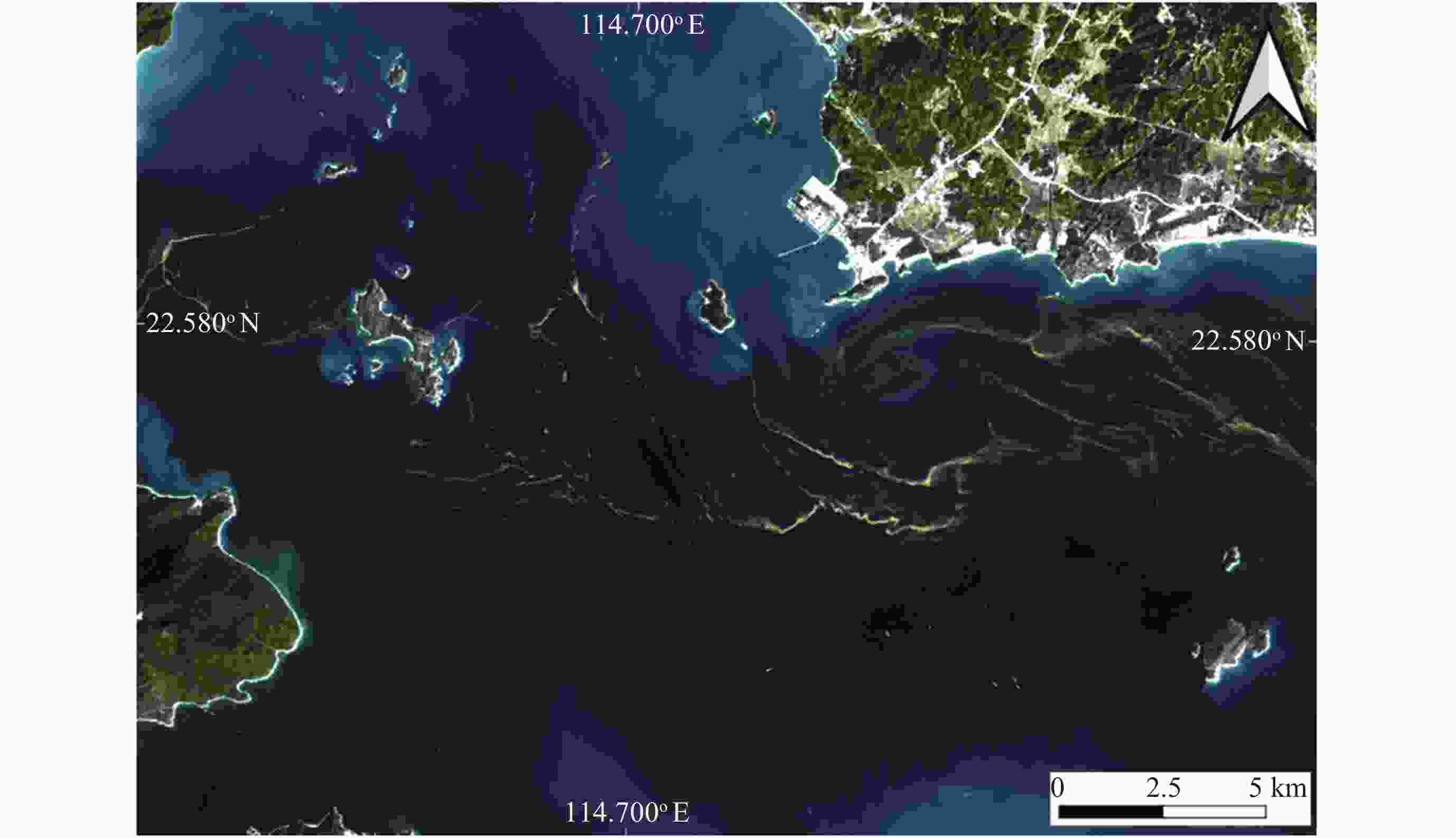
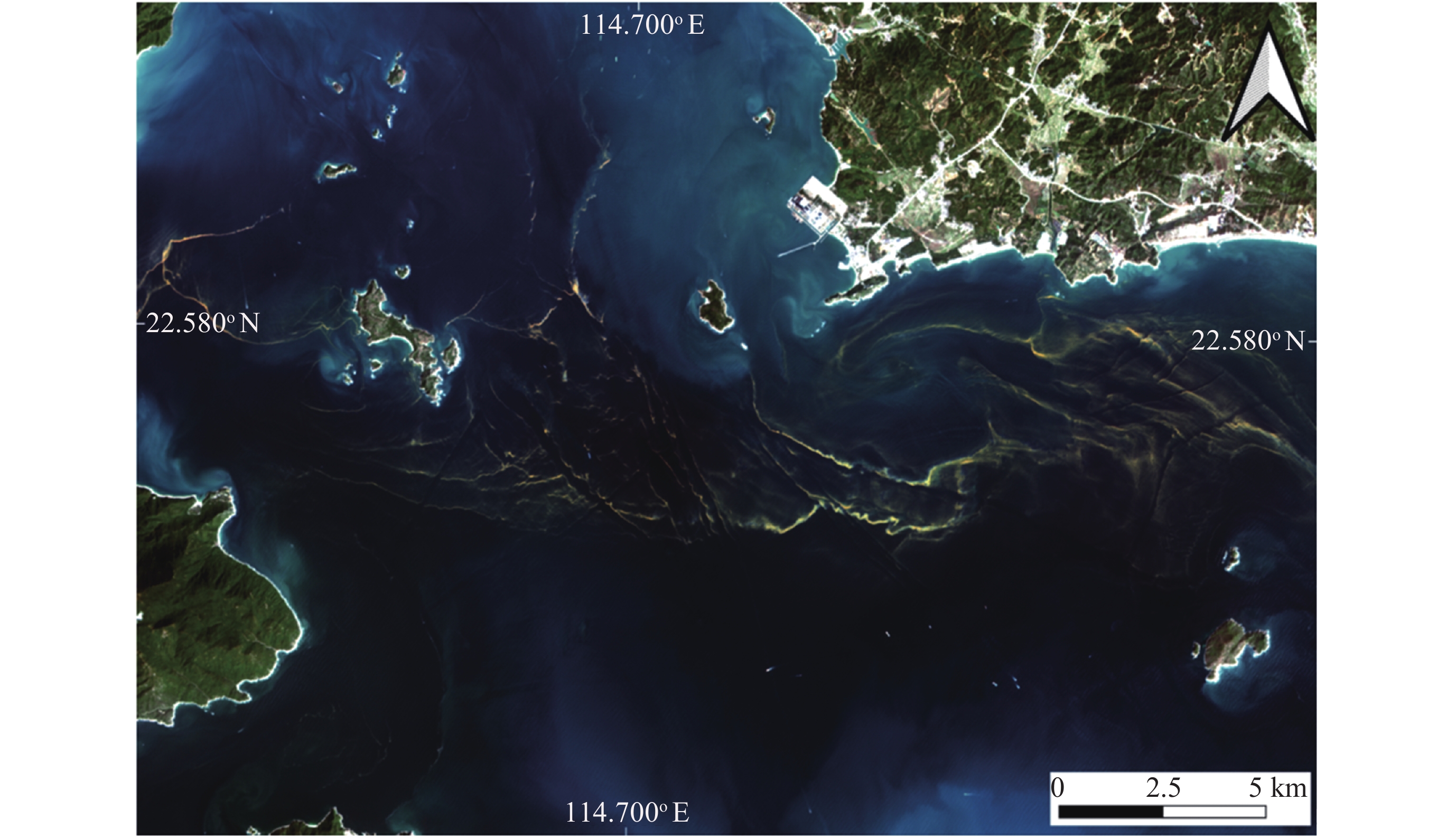
Figure 2. SDGSAT-1 MSI true RGB image (band combination: 5-4-3) of the red tide observed off the coast of Huizhou City, Guangdong Province, China, captured on 11 March 2022
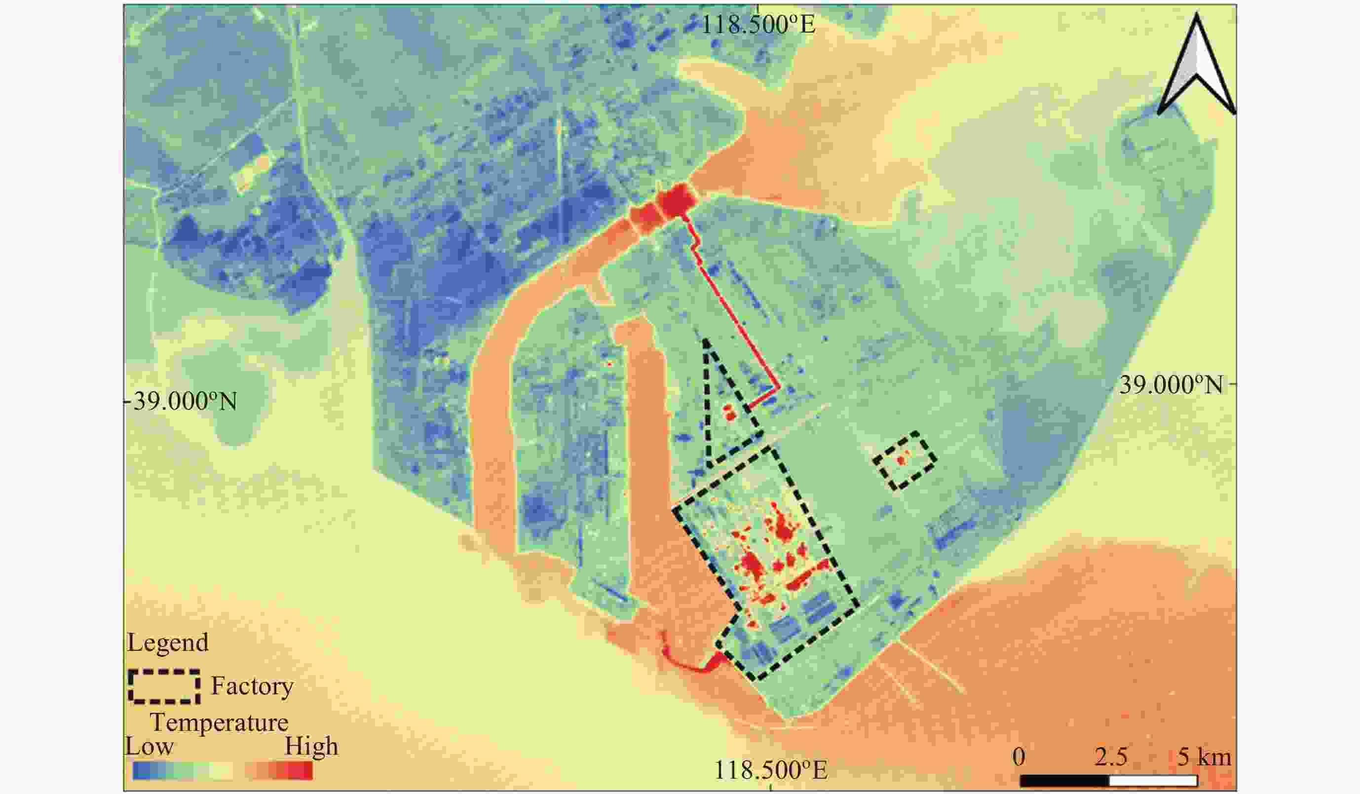
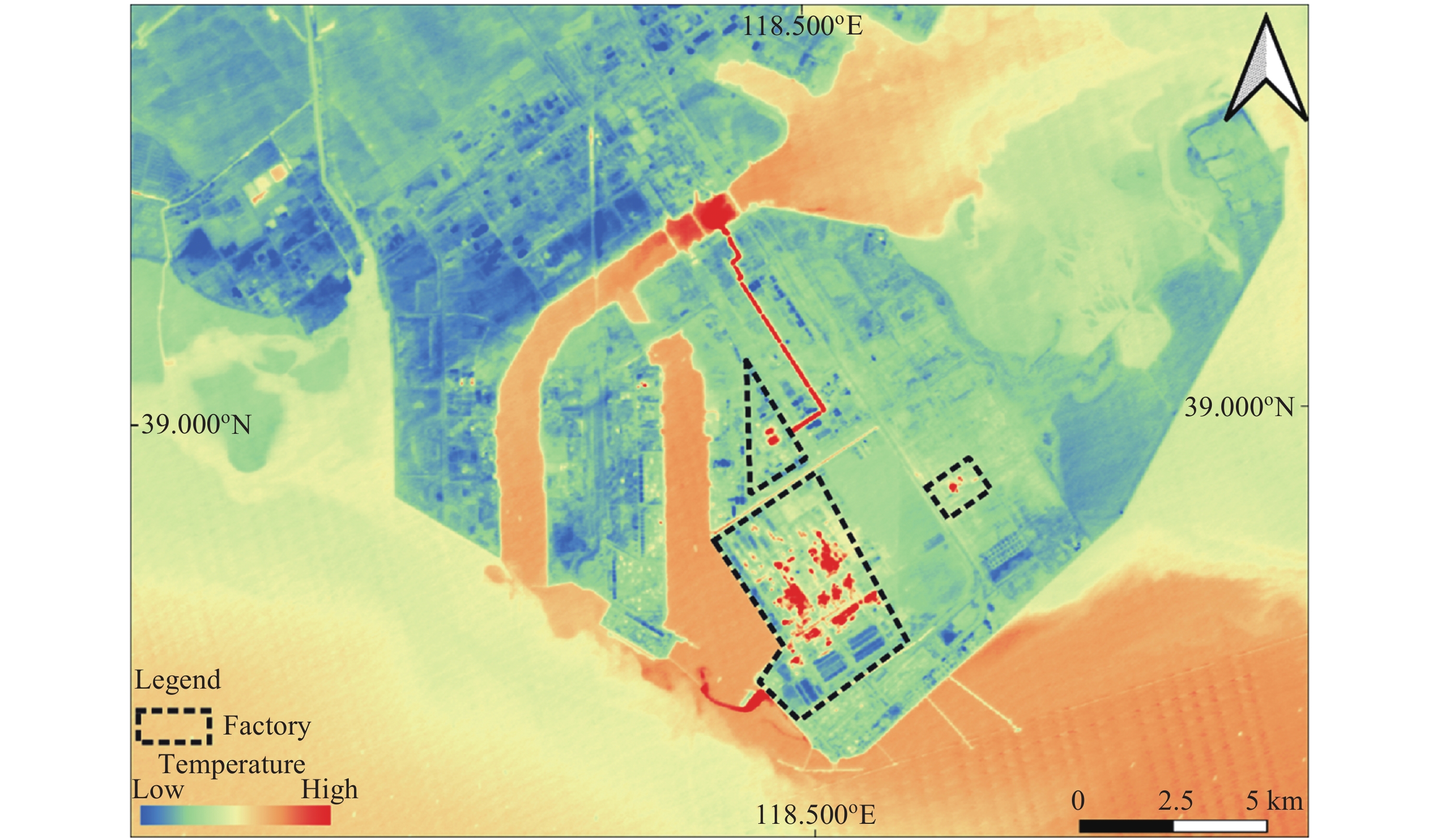
Figure 3. SDGSAT-1 TIS Band 2 nighttime imagery showing coastal factories in Tangshan City, Hebei Province, China on 10 January 2024. Heat sources within the factory perimeters are visible in the imagery. Water bodies around factories also have an elevated temperature relative to their surrounding environment
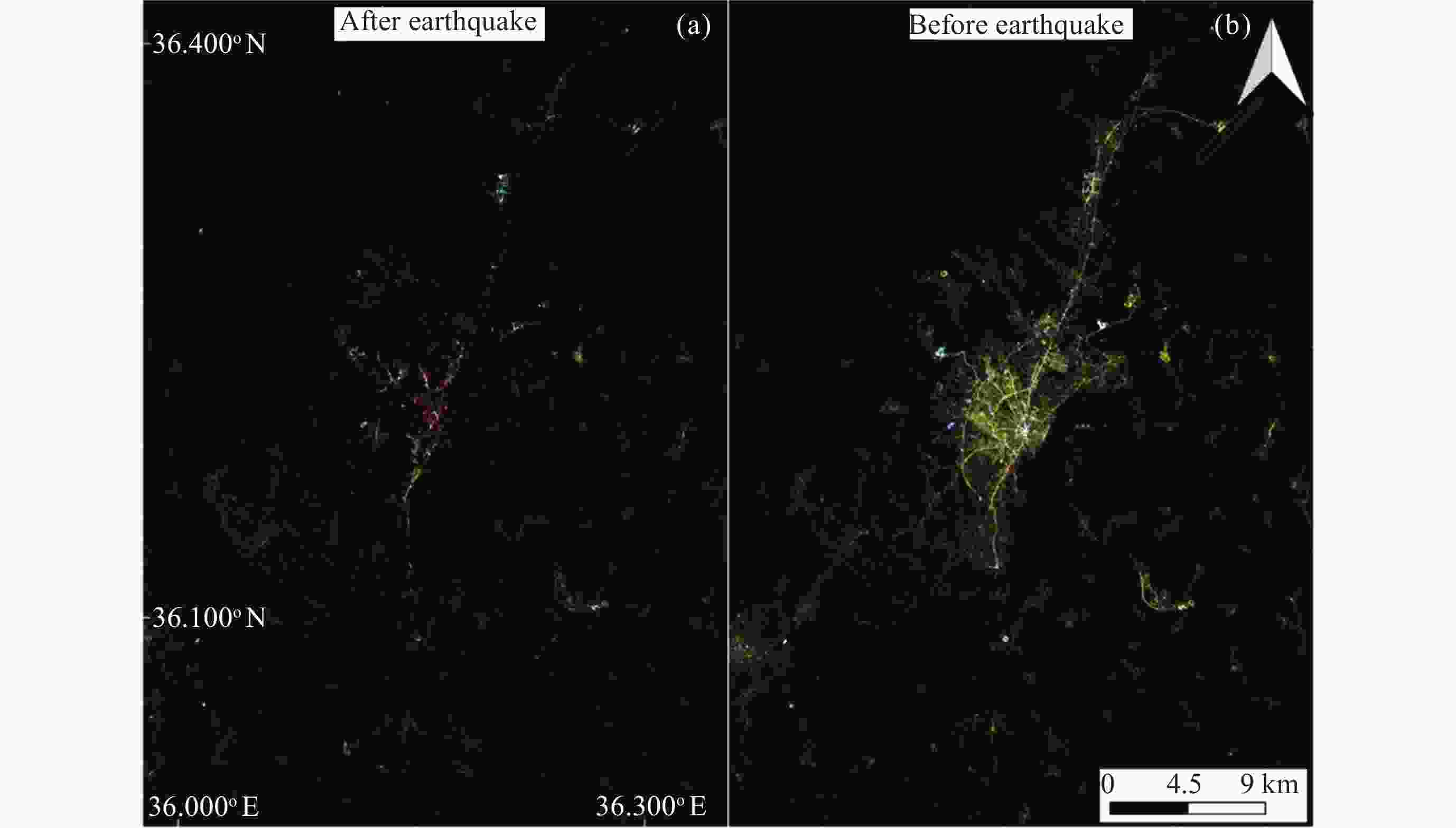
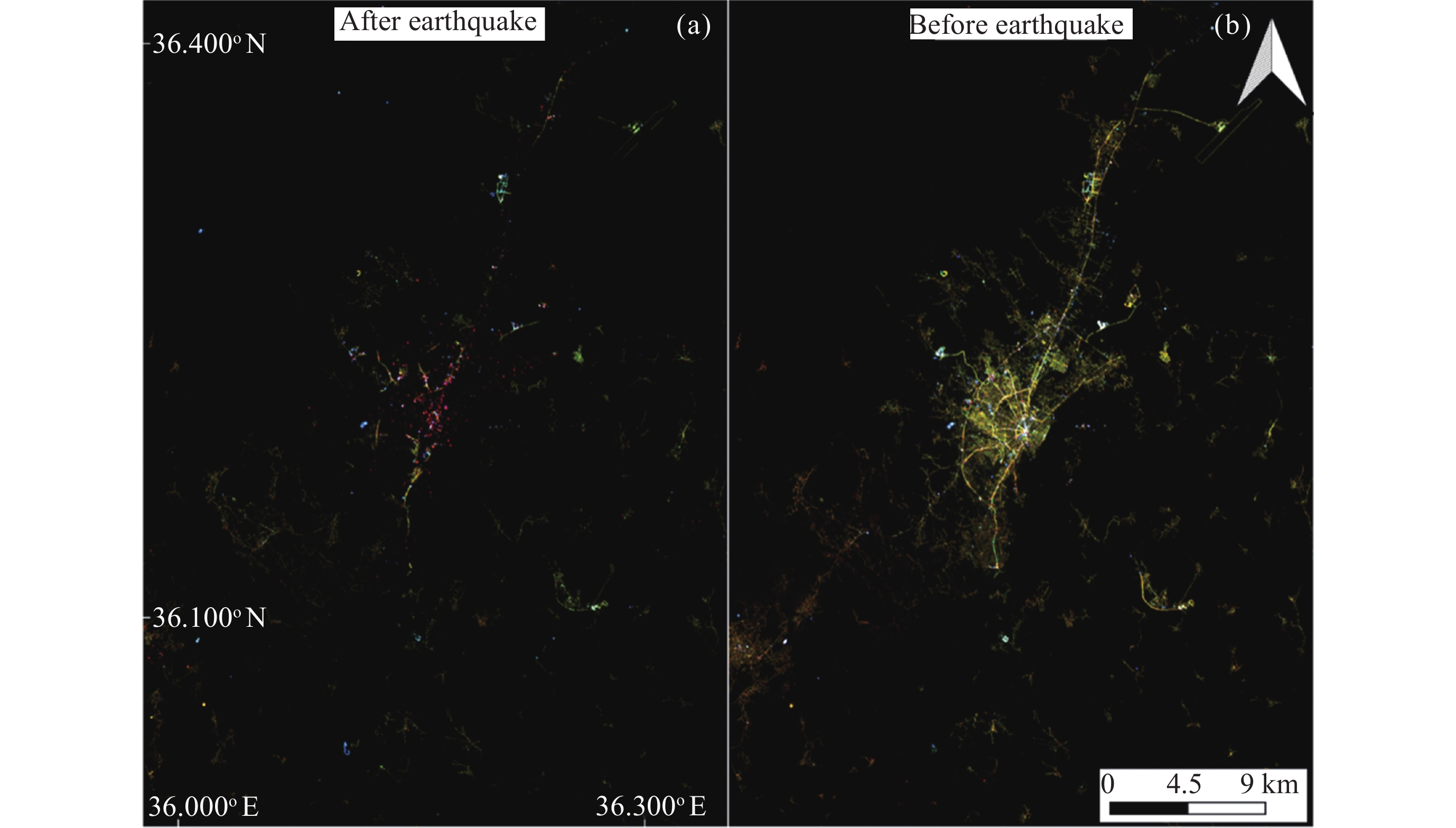
Figure 4. Comparison between SDGSAT-1 GLI imagery of Antakya, Hatay Province, Turkey, before and after the 2023 Turkey-Syria earthquakes. (a) RGB (band combination: 1-2-3) nighttime GLI imagery captured on 12 February 2023, after the earthquake, (b) RGB (band combination: 1-2-3) nighttime GLI imagery captured on 22 August 2022, before the earthquake, depicting bright nighttime light from roads and urban areas with precise details
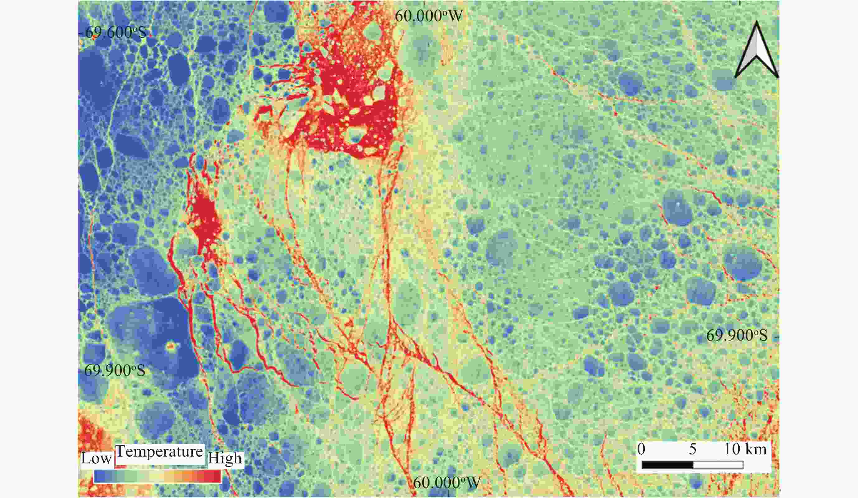
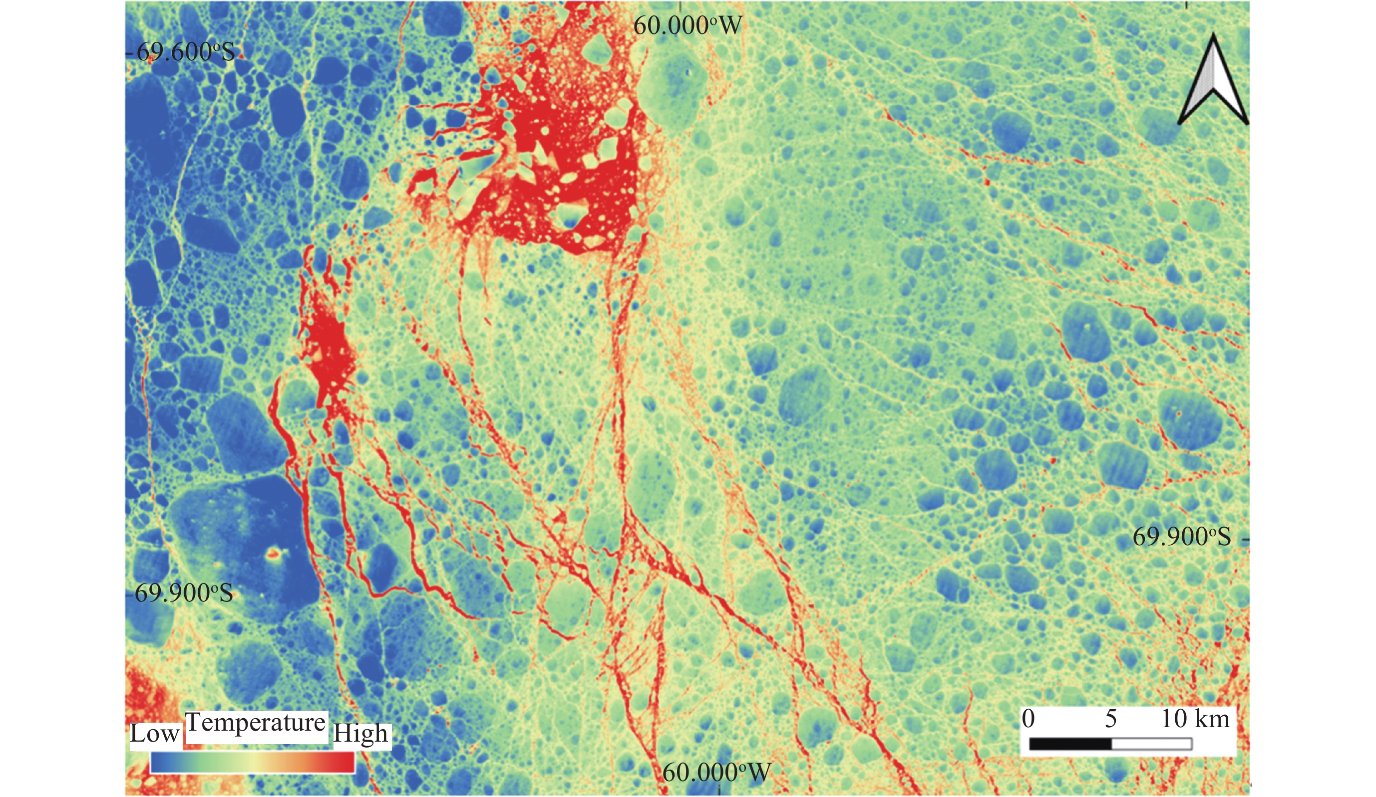
Figure 5. SDGSAT-1 TIS Band 2 imagery of the sea ice distribution near the Antarctic Peninsula. Imaging date: 16 February 2023
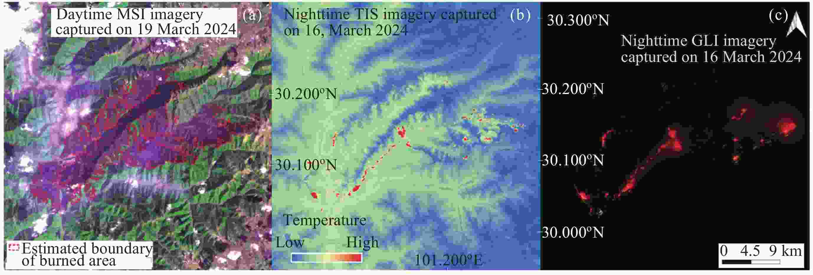
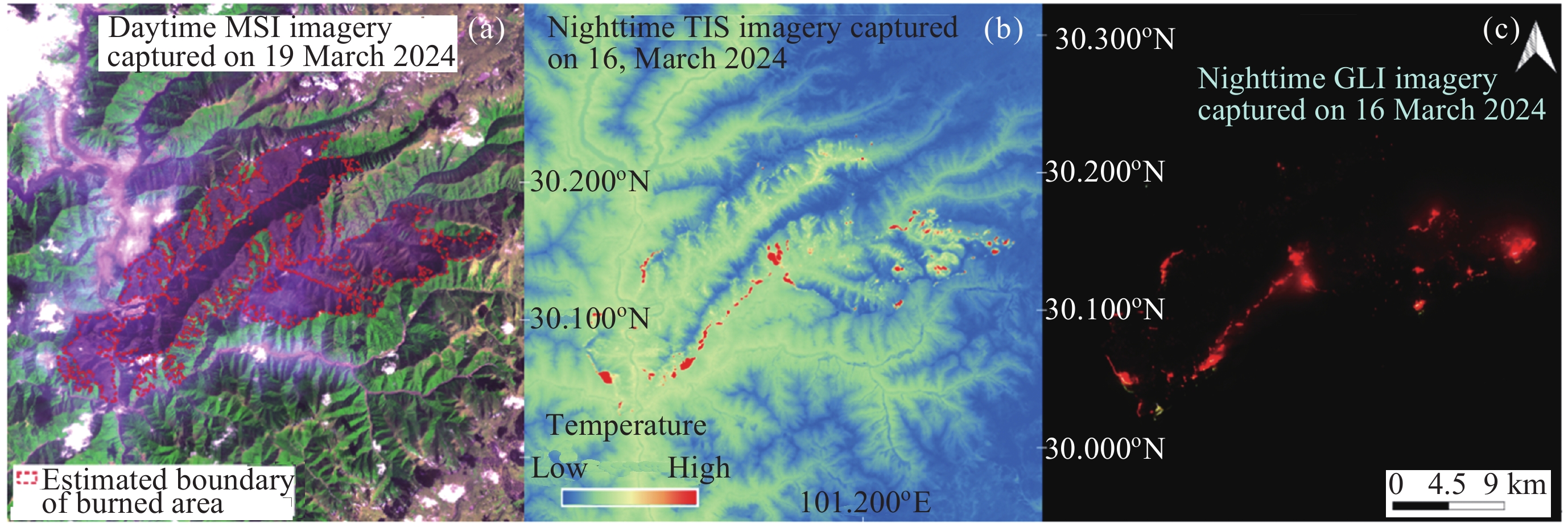
Figure 6. SDGSAT-1 three-sensor synergetic observation of the 2024 Ganzi forest fire. (a) MSI pseudo-RGB image (band combination: 5-6-3) captured on 19 March 2024, of burned areas near Yajiang County, Ganzi Prefecture, Sichuan Province, China. (b) TIS Band 2 nighttime imagery of the same area was captured on 16 March 2024. (c) GLI nighttime imagery (band combination: 1-2-3) captured on 16 March 2024, of the same location
Table 1. Technical parameters of three instruments onboard SDGSAT-1
Instrument Parameter Specification and unit Multispectral imager Swath width 300 km Spatial resolution 10 m Bands and central wavelengths Band 1 (deep blue): 400.63 nm
Band 2 (deep blue): 438.47 nm
Band 3 (blue): 495.10 nm
Band 4 (green): 553.23 nm
Band 5 (red): 656.75 nm
Band 6 (red edge): 776.12 nm
Band 7 (near-infrared): 854.02 nmThermal infrared spectrometer Swath width 300 km Spatial resolution 30 m Bands and central wavelengths Band 1: 9.35 μm
Band 2: 10.73 μm
Band 3: 11.72 μmGlimmer imager Swath width 300 km Spatial resolution Panchromatic: 10 m. RGB: 40 m Bands and central wavelengths Blue band: 478.87 nm
Green band: 561.20 nm
Red band: 734.25 nm
Panchromatic band: 680.72 nm 下载: 导出CSV
-
[1] United Nations. Sustainable Development Goals Progress Chart 2023[R]. New York: United Nations, 2023 [2] GUO H D, DOU C Y, CHEN H Y, et al. SDGSAT-1: the world’s first scientific satellite for sustainable development goals[J]. Science Bulletin, 2023, 68(1): 34-38 doi: 10.1016/j.scib.2022.12.014 [3] ESA. Earth Observation for SDG: Compendium of Earth Observation Contributions to the SDG Targets and Indicators[R]. Harwell: ESA, 2020 [4] United Nations. The “Space2030” Agenda: Space As a Driver of Sustainable Development[R]. New York: United Nations, 2021 [5] GUO H D, CHEN H Y, CHEN L F, et al. Progress on CASEarth satellite development[J]. Chinese Journal of Space Science, 2020, 40(5): 707-717 doi: 10.11728/cjss2020.05.707 [6] GUO H, DOU C, CHEN H, et al. Progress of SDGSAT-1 mission[J]. Chinese Journal of Space Science, 2022, 42(4): 44-48 [7] CUI Z Z, MA C, ZHANG H, et al. Vicarious radiometric calibration of the multispectral imager onboard SDGSAT-1 over the Dunhuang calibration site, China[J]. Remote Sensing, 2023, 15(10): 2578 doi: 10.3390/rs15102578 [8] CBAS. SDGSAT-1 Data Users Handbook[EB/OL]. Beijing: CBAS. [2024-04-26]. https://www.sdgsat.ac.cn/userGuide/document [9] HU Y H, LI X M, DOU C Y, et al. Absolute radiometric calibration evaluation of the thermal infrared spectrometer onboard SDGSAT-1[J]. International Journal of Digital Earth, 2023, 16(2): 4492-4511 doi: 10.1080/17538947.2023.2274418 [10] QI L T, LI L Y, NI X Y, et al. On-orbit spatial quality evaluation of SDGSAT-1 thermal infrared spectrometer[J]. IEEE Geoscience and Remote Sensing Letters, 2022, 19: 7507505 [11] YANG L, LI X Y, JIANG L Y, et al. Resolution-normalizing image stitching for long-linear-array and wide-swath whiskbroom payloads[J]. IEEE Geoscience and Remote Sensing Letters, 2022, 19: 7507705 [12] QI L T, ZHANG R G, HU Z Y, et al. Fast thermal infrared image restoration method based on on-orbit invariant modulation transfer function[J]. IEEE Transactions on Geoscience and Remote Sensing, 2024, 62: 5001015 [13] ZHONG X, ZHAO L H, REN P, et al. Land surface emissivity retrieval from SDGSAT-1: comparison of LSE products with different spatial resolutions[J]. International Journal of Digital Earth, 2024, 17(1): 2297940 doi: 10.1080/17538947.2023.2297940 [14] YAN L, HU Y H, DOU C Y, et al. Radiometric calibration of SDGSAT-1 nighttime light payload[J]. IEEE Transactions on Geoscience and Remote Sensing, 2024, 62: 1000715 [15] LIU S Y, WANG C X, CHEN Z Q, et al. Efficacy of the SDGSAT-1 glimmer imagery in measuring sustainable development goal indicators 7.1. 1, 11.5. 2, and target 7.3[J]. Remote Sensing of Environment, 2024, 305: 114079 doi: 10.1016/j.rse.2024.114079 [16] WANG N, HU Y H, LI X M, et al. Enhancing SDGSAT-1 night light images using a panchromatic guidance denoising algorithm[J]. International Journal of Applied Earth Observation and Geoinformation, 2024, 128: 103748 doi: 10.1016/j.jag.2024.103748 [17] ZHANG D G, CHENG B, SHI L, et al. A destriping algorithm for SDGSAT-1 nighttime light images based on anomaly detection and spectral similarity restoration[J]. Remote Sensing, 2022, 14(21): 5544 doi: 10.3390/rs14215544 [18] LI H, JING L H, DOU C Y, et al. A comprehensive assessment of the pansharpening of the nighttime light imagery of the glimmer imager of the sustainable development science satellite 1[J]. Remote Sensing, 2024, 16(2): 245 doi: 10.3390/rs16020245 [19] WU J, YE H B, LIU Y M, et al. The evaluation of MII/SDGSAT-1 in red tide detection along the guangdong middle coast[J]. IEEE Geoscience and Remote Sensing Letters, 2024, 21: 1500305 [20] HOU Y Z, XING Q G, ZHENG X Y, et al. Monitoring suspended sediment concentration in the Yellow River estuary and its vicinity waters on the basis of SDGSAT-1 multispectral imager[J]. Water, 2023, 15(19): 3522 doi: 10.3390/w15193522 [21] SANG R D, WANG Y O, ZHANG F F, et al. A novel water optical types framework for Chinese inland waters with the application of multitype satellite sensor[J]. International Journal of Digital Earth, 2024, 17(1): 2327834 doi: 10.1080/17538947.2024.2327834 [22] HU X K, LI J G, SUN Y, et al. Retrieval of total suspended matter concentration based on the iterative analysis of multiple equations: a case study of a lake Taihu image from the first sustainable development goals science satellite’s multispectral imager for inshore[J]. Remote Sensing, 2024, 16(8): 1385 doi: 10.3390/rs16081385 [23] HUANG W W, JIAO J J, ZHAO L X, et al. Thermal discharge temperature retrieval and monitoring of NPPs based on SDGSAT-1 images[J]. Remote Sensing, 2023, 15(9): 2298 doi: 10.3390/rs15092298 [24] WANG D C, XIE Y M, MA C H, et al. Identification of industrial heat source production areas based on SDGSAT-1 thermal infrared imager[J]. Applied Sciences, 2024, 14(6): 2450 doi: 10.3390/app14062450 [25] LEVIN N. Using night lights from space to assess areas impacted by the 2023 turkey earthquake[J]. Remote Sensing, 2023, 15(8): 2120 doi: 10.3390/rs15082120 [26] YU B, CHEN F, WANG N, et al. Assessing changes in nighttime lighting in the aftermath of the Turkey-Syria earthquake using SDGSAT-1 satellite data[J]. The Innovation, 2023, 4(3): 100419 doi: 10.1016/j.xinn.2023.100419 [27] UNOSAT. Night-time light loss assessment in Derna & Al Bayda (Libya) using night-time light imagery[EB/OL]. Geneva: UNOSAT. [2024-04-26]. https://unosat.org/products/3678 [28] UNOSAT. Power outage assessment in Sudan using night-time light imagery[EB/OL]. Geneva: UNOSAT. [2024-04-26]. https://unosat.org/products/3625 [29] IRDR. Analysis of Gansu Jishishan earthquake based on nighttime light[EB/OL]. Geneva: UNDRR. [2024-04-26]. https://www.preventionweb.net/publication/analysis-gansu-jishishan-earthquake-based-nighttime-light [30] JIA M M, ZENG H H, CHEN Z Q, et al. Nighttime light in China’s coastal zone: the type classification approach using SDGSAT-1 Glimmer Imager[J]. Remote Sensing of Environment, 2024, 305: 114104 doi: 10.1016/j.rse.2024.114104 [31] GUO B Y, HU D Y, ZHENG Q M. Potentiality of SDGSAT-1 glimmer imagery to investigate the spatial variability in nighttime lights[J]. International Journal of Applied Earth Observation and Geoinformation, 2023, 119: 103313 doi: 10.1016/j.jag.2023.103313 [32] LIN Z R, JIAO W L, LIU H C, et al. Modelling the public perception of urban public space lighting based on sdgsat-1 glimmer imagery: a case study in Beijing, China[J]. Sustainable Cities and Society, 2023, 88: 104272 doi: 10.1016/j.scs.2022.104272 [33] LIU S M, ZHOU Y, WANG F T, et al. Lighting characteristics of public space in urban functional areas based on SDGSAT-1 glimmer imagery: a case study in Beijing, China[J]. Remote Sensing of Environment, 2024, 306: 114137 doi: 10.1016/j.rse.2024.114137 [34] Universidad Complutense de Madrid. High-Resolution Calibrated Light Pollution Map of the Iberian Peninsula[EB/OL]. Madrid: Universidad Complutense de Madrid. [2024-04-26]. https://pmisson.users.earthengine.app/view/sdgsat-1-p-iberica [35] SENANDE-RIVERA M, INSUA-COSTA D, MIGUEZ-MACHO G. Spatial and temporal expansion of global wildland fire activity in response to climate change[J]. Nature Communications, 2022, 13(1): 1208 doi: 10.1038/s41467-022-28835-2 [36] TABARI H. Climate change impact on flood and extreme precipitation increases with water availability[J]. Scientific Reports, 2020, 10(1): 13768 doi: 10.1038/s41598-020-70816-2 [37] WUNDERLING N, WILLEIT M, DONGES J F, et al. Global warming due to loss of large ice masses and Arctic summer sea ice[J]. Nature Communications, 2020, 11(1): 5177 doi: 10.1038/s41467-020-18934-3 [38] QIU Y J, LI X M, GUO H D. Spaceborne thermal infrared observations of Arctic sea ice leads at 30 m resolution[J]. The Cryosphere, 2023, 17(7): 2829-2849 doi: 10.5194/tc-17-2829-2023 -
-

 下载:
下载:

计量
- 文章访问数: 1167
- HTML全文浏览量: 457
- PDF下载量: 61
-
被引次数:
0(来源:Crossref)
0(来源:其他)

