


Networking Observation and Applications of Chinese Ocean Satellites
doi: 10.11728/cjss2024.04.2024-yg22
-
Abstract: This paper presents the networking observation capabilities of Chinese ocean satellites and their diverse applications in ocean disaster prevention, ecological monitoring, and resource development. Since the inaugural launch in 2002, China has achieved substantial advancements in ocean satellite technology, forming an observation system composed of the HY-1, HY-2, and HY-3 series satellites. These satellites are integral to global ocean environmental monitoring due to their high resolution, extensive coverage, and frequent observations. Looking forward, China aims to further enhance and expand its ocean satellite capabilities through ongoing projects to support global environmental protection and sustainable development.
-
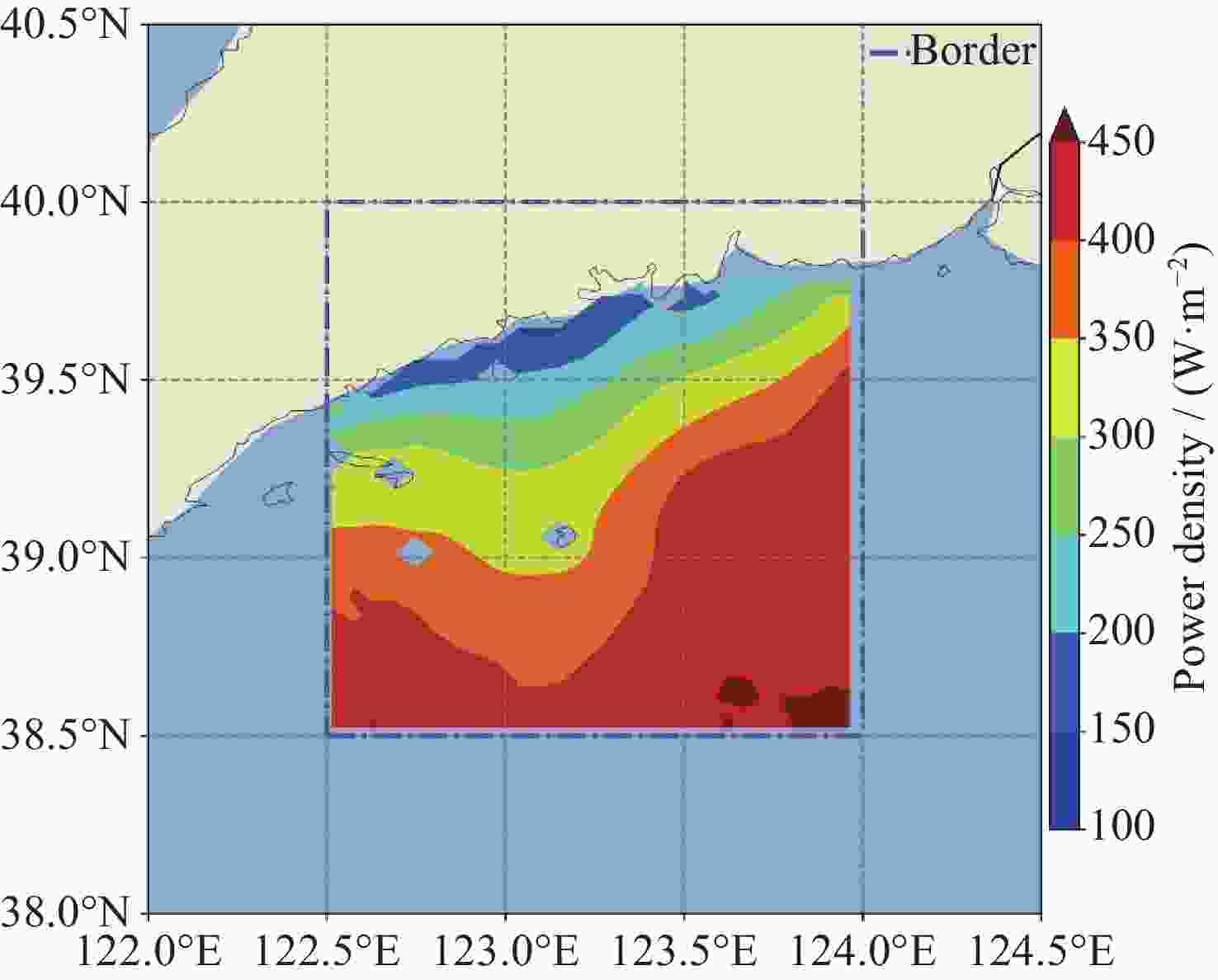
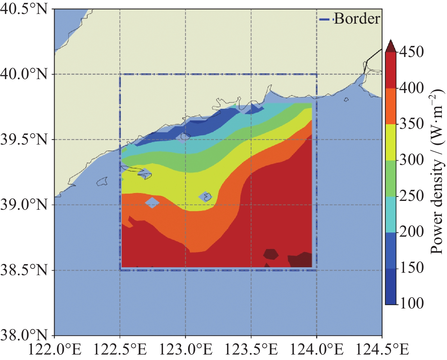
Figure 8. Wind energy average power density distribution assessment at 100 m height in the Zhuanghe sea area of the Bohai Sea, China
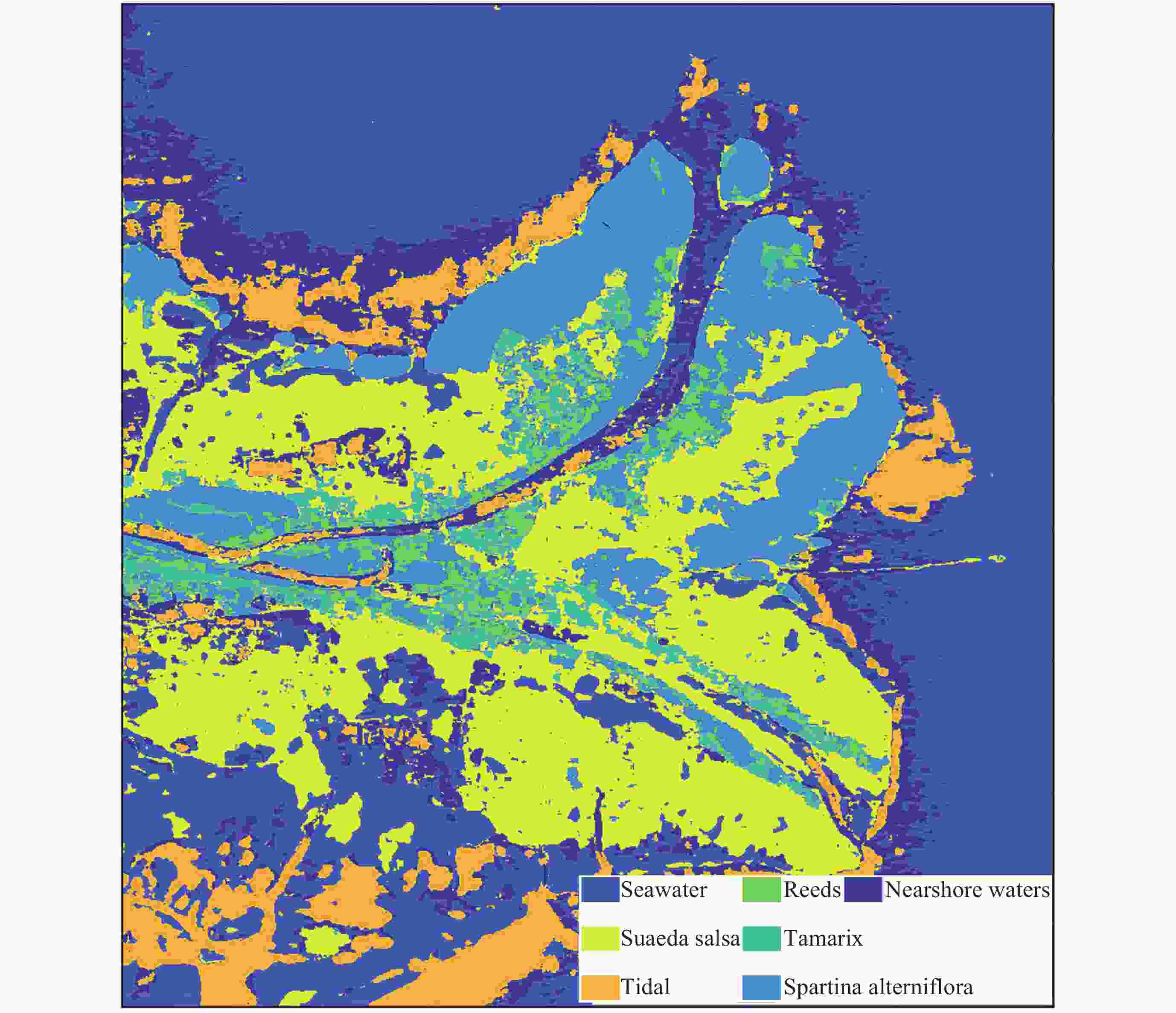
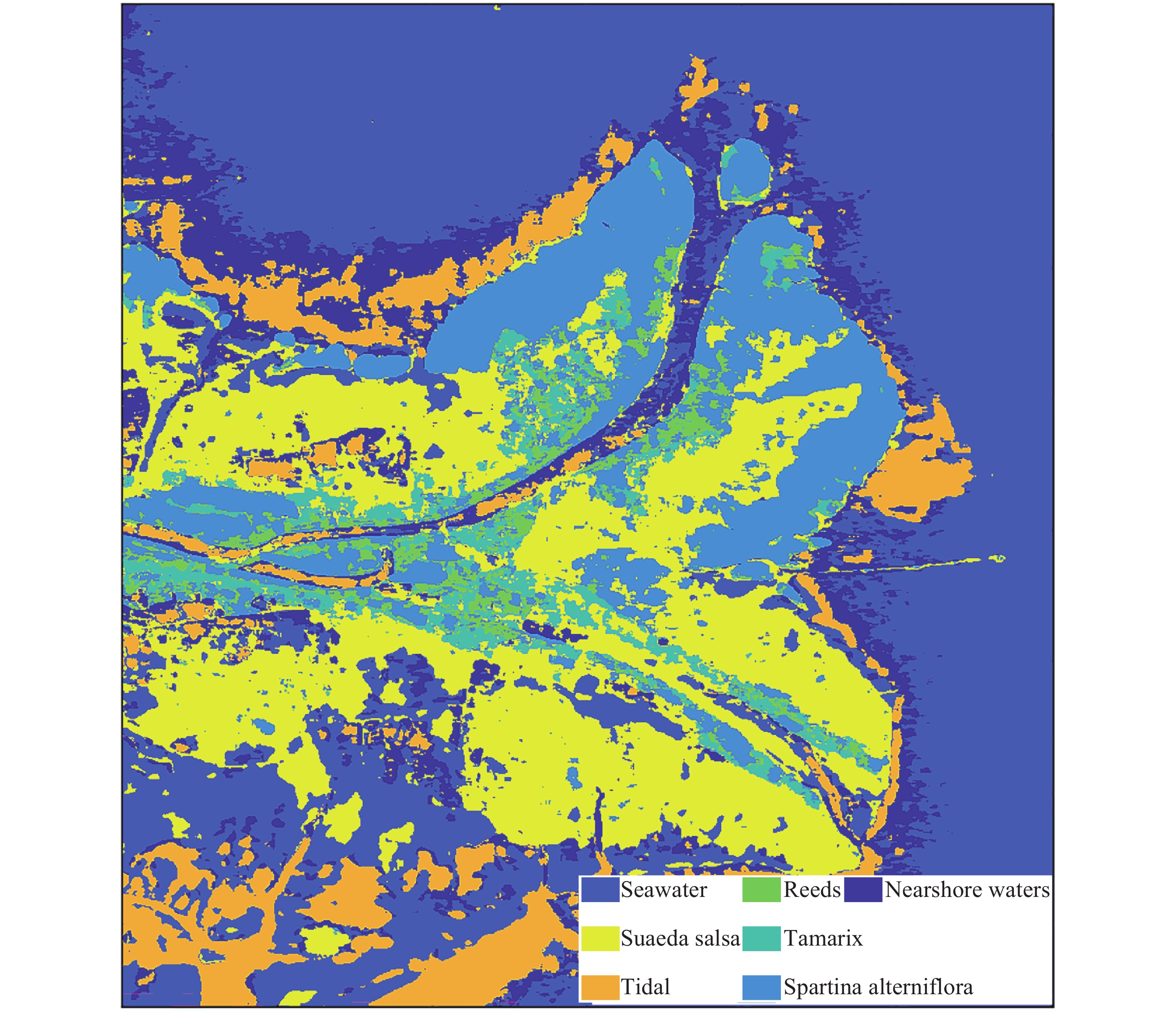
Figure 9. Wetland classification in the Yellow River Delta based on SAR polarization decomposition data

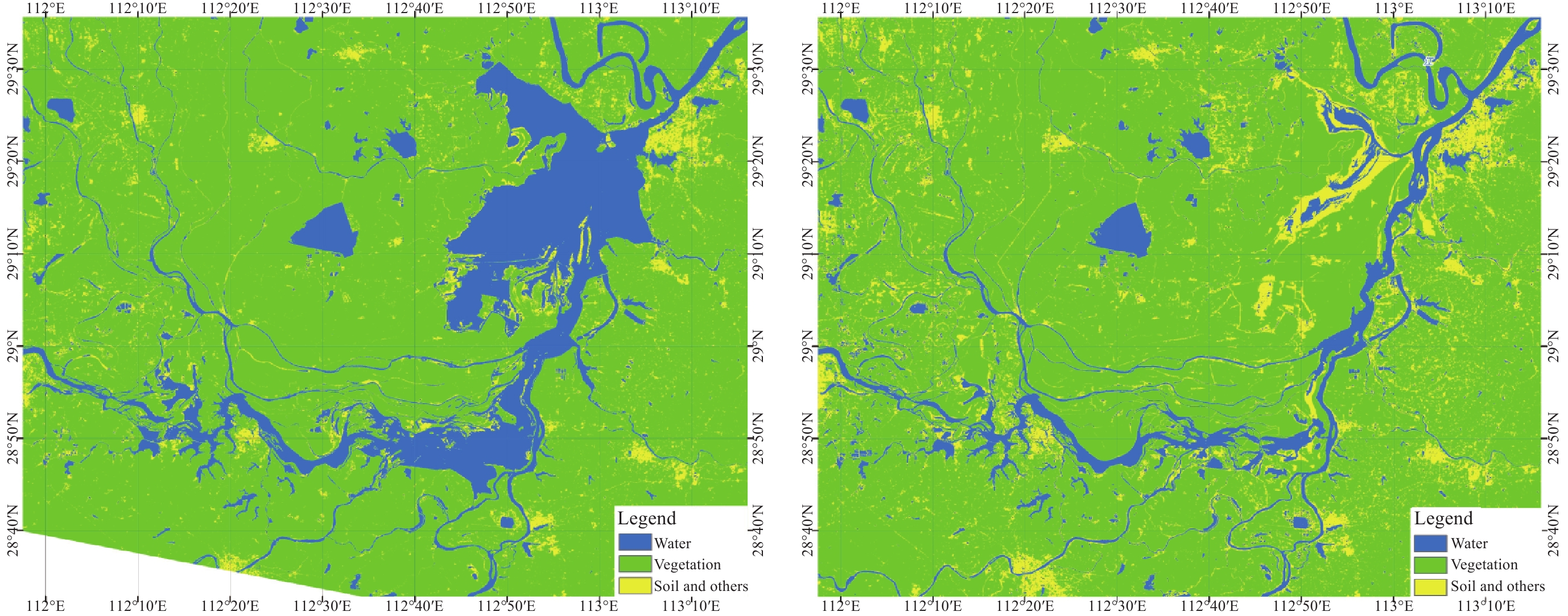
Figure 12. Comparison of the water surface area of Poyang Lake between 22 August 2022 and 31 August 2021
Table 1. Launch details of Chinese ocean satellites
Satellite Series Launch date Operational status HY-1A Ocean color satellite May 2002 Ceased March 2004 HY-1B April 2007 Ceased February 2016 HY-1C September 2018 Operational HY-1D June 2020 Operational HY-1E November 2023 Testing HY-2A Ocean dynamic environment satellite August 2011 Ceased February 2024 HY-2B October 2018 Operational HY-2C September 2020 Operational HY-2D May 2021 Operational CFOSAT October 2018 Operational GF-3 Ocean surveillance and monitoring satellite August 2016 Operational 1 m C-SAR 01 November 2021 Operational 1 m C-SAR 02 April 2022 Operational  下载: 导出CSV
Table 2. Observation capabilities of HY-1C/D/E
Payload Spatial resolution Band number Swath width Monitoring capability Networking coverage capability CZI 50 m (20 m+5 m) 4 (8+1) 950 km (60 km, up to 1000 km side imaging) Coastal zones, sea ice, red tide, ulva prolifera, suspended sediments, coral reefs, coastal wetlands, invasive species, mangroves, pollutants, large water bodies, vegetation, etc. Once daily PMRIS Multi-spectral 100 m/Hyperspectral 200 m Multi-spectral 19/ Hyperspectral 94 950 km COCTS 1 km (500 m) 10 (18) 2900 km (3000 km) Chlorophyll concentration, suspended sediments, dissolved organic matter, SST, polar sea ice, large water bodies, vegetation, soil moisture, etc. Ocean color 3 times/day, SST
6 times/dayNote Information in parentheses represents the HY-1E remote sensors.
下载: 导出CSV
Table 3. Observation capabilities of HY-2B/C/D
Payload Spatial resolution Working frequency Swath width Monitoring capability Networking coverage capability RA 7 km 13.585, 5.25 GHz 7 km SSH, significant wave
height, and gravity
field, etc.About 14-day
mesoscale coverageSMR (HY-2B only) 25–90 km 6.925, 10.7, 18.7, 23.8, 37.0 GHz 1600 km SST, sea surface water vapor content,
liquid water, and rain
intensity, etc.Daily coverage of
over 80% of open
oceanSCAT 25 km 13.256 GHz 1700 km SSW, etc. Global 85% coverage every six hours
下载: 导出CSV
Table 4. Observation capabilities of GF-3, 1 m C-SAR 01/02
Payload Spatial resolution Band number Swath width Monitoring capability Networking coverage capability SAR 1–500 m C-band, full polarization, 12 imaging modes 10–500 km Global maritime targets, ocean
structures, detailed ocean
dynamic environment parameters,
maritime emergency events, land use, surface water, etc.Daily
下载: 导出CSV
-
[1] JIANG X, SONG Q. Ocean satellite programs in China[J]. Comprehensive Remote Sensing, 2018, 8: 278-283 doi: 10.1016/B978-0-12-409548-9.10409-9 [2] NSOAS. Successful launch of the new generation ocean color observation satellite[EB/OL]. (2023-11-17) http://www.nsoas.org.cn/eng/item/266.html [3] NSOAS. HY-1 series[EB/OL]. (2024-4-12) http://www.nsoas.org.cn/eng/column/145.html [4] NSOAS. HY-2 series[EB/OL]. (2024-4-12) http://www.nsoas.org.cn/eng/column/146.html [5] WANG L L, DING Z Y, ZHANG L, et al. CFOSAT-1 realizes first joint observation of sea wind and waves[J]. Aerospace China, 2019, 20(1): 20-27 [6] NSOAS. On-orbit tests of 1-meter C-SAR 01 and 02 satellites were successfully completed[EB/OL]. (2023-2-22) http://www.nsoas.org.cn/eng/item/264.html [7] LIU Jianqiang, LU Yingcheng, DING Jing, et al. Oil spills in China Seas revealed by the national ocean color satellites[J]. Chinese Science Bulletin, 2022, 67(33): 3997-4008 doi: 10.1360/TB-2021-0992 -
-

 下载:
下载:

计量
- 文章访问数: 696
- HTML全文浏览量: 391
- PDF下载量: 30
-
被引次数:
0(来源:Crossref)
0(来源:其他)

