


Recent Progress of Earth Observation Satellites in China
doi: 10.11728/cjss2024.04.2024-yg23
-
Abstract: Currently, China has 32 Earth observation satellites in orbit. The satellites can provide various data such as optical, multispectral, infrared, and radar. The spatial resolution of China Earth observation satellites ranges from low to medium to high. The satellites possess the capability to observe across multiple spectral bands, under all weather conditions, and at all times. The data of China Earth observation satellites has been widely used in fields such as natural resource detection, environmental monitoring and protection, disaster prevention and reduction, urban planning and mapping, agricultural and forestry surveys, land survey and geological prospecting, and ocean forecasting, achieving huge social benefits. This article introduces the recent progress of Earth observation satellites in China since 2022, especially the satellite operation, data archiving, data distribution and data coverage.
-
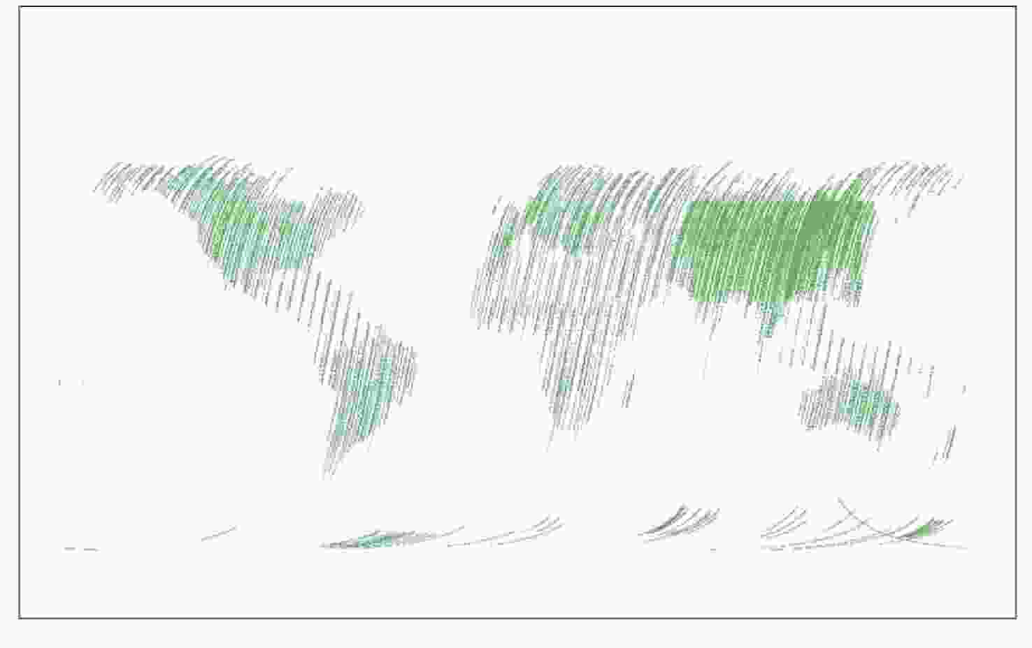
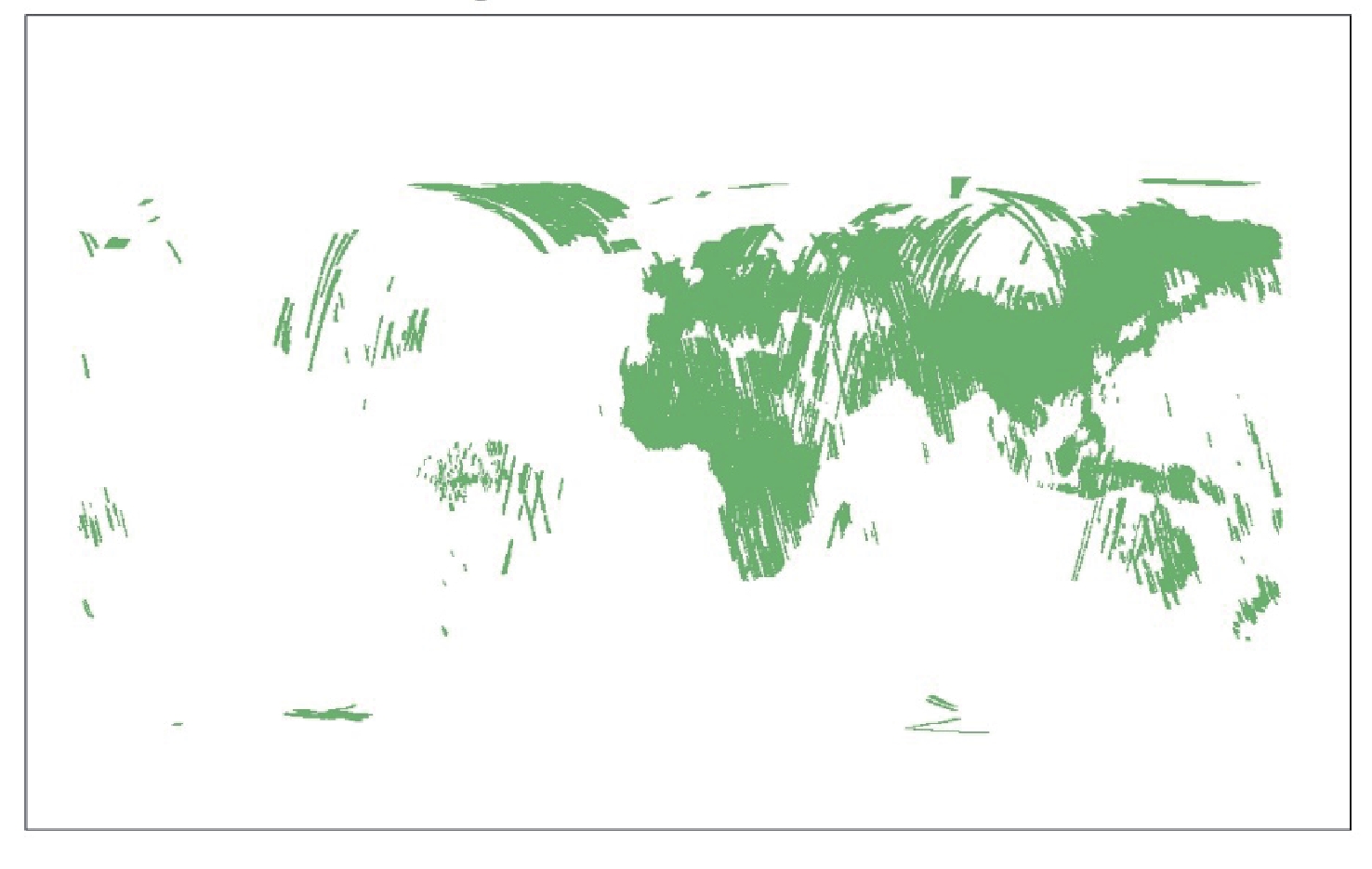
Figure 4. Global coverage of effective data of CM-1 (DMC) satellite (as of 31 May 2024)
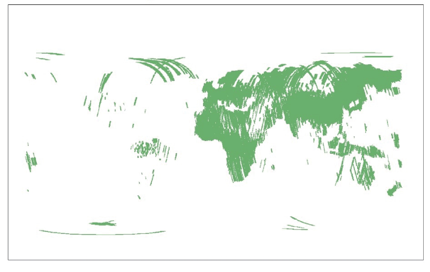
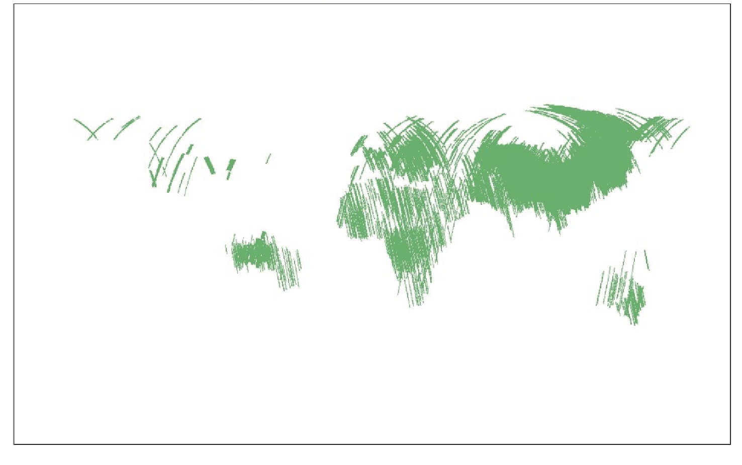
Figure 7. Global coverage of effective data of GF-5 01 A (AHSI)satellite (as of 31 May 2024)
Table 1. List of new Earth observation satellites in China
Number Satellite name Code Launch time Design life / year 1 L-SAR 01 A LT-1A 26 Jan. 2022 8 2 L-SAR 01 B LT-1B 27 Feb. 2022 8 3 Gaofen-3 03 GF-3C 7 Apr. 2022 8 4 Atmospheric environment monitoring satellite DQ-1 16 Apr. 2022 8 5 Terrestrial ecosystem carbon monitoring satellite CM-1 4 Aug. 2022 8 6 5 m S-SAR 01 HJ-2E 13 Oct. 2022 8 7 Gaofen-5 01 A GF-5 01 A 9 Dec. 2022 8 8 5 m S-SAR 02 HJ-2F 9 Aug. 2023 8 9 Land Exploration Satellite 4-01 JZ-1 13 Aug. 2023 8  下载: 导出CSV
Table 2. Imaging mode of LT-1A and LT-1B
Serial number Imaging mode Resolution/m Imaging width/km Polarization mode 1 Strip mode 1 3 50 Optional single polarization 2 Strip mode 2 12 100 Optional single polarization 3 Strip mode 3 3 50 Optional dual polarization 4 Strip mode 4 6 30 Total polarization 5 Strip mode 5 20‒30 150‒250 Optional single polarization 6 Scan mode 30 400 Optional single polarization
下载: 导出CSV
Table 3. Imaging mode of GF-3C
Number Imaging mode Resolution /m Imaging
width /km
Total number
of viewsPolarization mode Nominal Azimuthal direction Distance direction Nominal Range 1 Bunching 1 1.0‒1.5 0.9–2.5 10 × 10 10 × 10 1 Optional single polarization 2 Hyperfine strip 3 3 2.5‒5 30 30 1 Optional single polarization 3 Fine strip 1 5 5 4‒6 50 50 1 Optional dual polarization 4 Fine strip 2 10 10 8‒12 100 95‒110 2 Optional dual polarization 5 Standard strip 25 25 15‒30 130 95‒150 6 Optional dual polarization 6 Narrow range topsar 50 50‒60 30‒60 300 300 6 Optional dual polarization 7 Wide range topsar 100 100 50‒110 500 500 8 Optional dual polarization 8 Fully polarized strip 1 8 8 6‒9 30 20‒35 1 Total polarization 9 Fully polarized strip 2 25 25 15‒30 40 35‒50 6 Total polarization 10 Wave imaging mode 8 8 6‒9 20 × 20 20 × 20 1 Total polarization 11 Global topsar model 500 500 350‒700 650 650 12 Optional dual polarization 12 Extend
incident angleLow incident angle 25 25 15‒30 130 120‒150 6 Optional dual polarization High incident angle 25 25 20‒30 80 70‒90 6 Optional dual polarization Note 1 Ground distance.
Note 2 The time interval between two consecutive observations is about 10 s, and the imaging range in azimuth and range is 10 km respectively.
Note 3 The interval between two consecutive observations is about 100 km, which can be adjusted. The imaging range in azimuth and range is 20 km respectively.
Note 4 The total viewing number is azimuth viewing number by distance viewing number.
Note 5 With GMTI and high resolution and wide range test mode.
下载: 导出CSV
Table 4. Payloads of DQ-1
Atmospheric lidar Detection center wavelength/nm 532, 1064, 1572 Repetition frequency/Hz 20 (Double pulse) Laser pulse width/ns 15 Main telescope aperture/m 1 High precision scanning polarimeter Center wavelength/nm 380, 410, 443, 490, 670, 865, 1380, 1610, 2250;
Each channel has polarization detection capabilitySpatial resolution/km Better than 10 Width/km ≥ 1800 Polarization measurement accuracy Better than 0.5% Directional polarization camera Spectral range/nm 433‒453, 480‒500 (P)
555‒575, 660‒680 (P)
758‒768, 745‒785
845‒885 (P), 900‒920spatial resolution/km Better than 3.5 Width/km ≥ 1800 Polarization measurement accuracy Better than 2% Ultraviolet hyperspectral atmospheric composition detector Spectral range/nm 240‒315, 315‒403, 403‒550, 550‒710 Width/km ≥ 2300 Spectral resolution/nm Better than 0.3‒0.5 Spatial resolution/km Better than 24 (rail crossing direction) by 13 (along rail direction) Wide imaging spectrometer Spectral range/μm 0.415, 0.443, 0.47, 0.49, 0.555, 0.659, 0.681, 0.753, 0.8 (Panchromatic channel),
0.865, 0.936, 0.94, 1.375, 1.64, 2.13, 3.8 (High gain), 3.8 (Low gain),
7.325, 8.55, 10.8, 12.0spatial resolution/m 75 (Panchromatic channel), 150 (True color channel),
300 (Long wave infrared split window), Other channels: 600Width/km ≥ 2300
下载: 导出CSV
Table 5. Payloads of CM-1
Multi-beam lidar Laser beam Vegetation detection 5 beam, aerosol detection 1 beam Laser wavelength/nm 1064/532 Laser altimeter range/km 506 ± 20 Aerosol polarization detection/nm Horizontal and vertical polarization (532) Ranging accuracy (static)/m ≤ 0.3 Vertical sampling interval for aerosol detection/m ≤ 30 Multi-angle and multi-spectral camera Angle 0° camera ± 19° camera ± 41° camera Spectral segment/nm B1 band: 450‒520
B2 band: 520‒590
B3 band: 630‒690
B4 band: 770‒890B1 band: 450‒520
B2 band: 520‒590
B3 band: 630‒690
B4 band: 770‒890
P-band: 500‒760B1 band: 450‒520
B2 band: 520‒590
B3 band: 630‒690
B4 band: 770‒890
B5 band: 690‒730Ground pixel resolution (vertical rail direction)/m Better than 2 Better than 4 / 8 (panchromatic/multispectral) Better than 6 /12 (red edge/multispectral) Static MTF ≥ 0.2 P-band ≥ 0.18, Others ≥ 0.2 B5 band ≥ 0.15, Others ≥ 0.2 Width/km ≥ 20 Quantization bits/bit 12 Hyperspectral detector Spectral segment 670‒780 nm, ≥ 366 channels Spectral resolution/nm ≤ 0.3 Ground pixel resolution/km ≤ 2 Width/km ≥ 30 Quantization bits / bit 14 Multi-angle polarization imager Working spectrum segment/nm There were 8 spectral bands: 433‒453, 480‒500 (P), 555‒575, 660‒680 (P), 758‒768, 745‒785, 845‒885 (P), 900‒920. 490, 670 and 865 spectral bands have polarization measurement capability Polarization analysis Linear polarization, three polarization directions 0°, 60°, 120° Multi-angle observation Along the rail ≥ 9 angles Subsatellite point spatial resolution/km ≤ 3.5 Width/km ≥ 800
下载: 导出CSV
Table 6. Imaging mode of HJ-2E and HJ-2F
Serial number Imaging mode Resolution /m Imaging width /km Visual number
A×EPolarization mode Nominal Azimuthal direction Distance direction Nominal Range 1 Unipolar stripe 5 5 3.7‒5 35 35‒41 1×1 Selectable single polarization 2 Dual polarization strip 5 5 3.7‒5 35 35‒41 1×1 Optional dual polarization 3 Monopolar scanning 25 20‒25 16.5‒24.5 95 95‒109 1×3
1×4Selectable single polarization 4 Dual polarization scanning 25 20‒25 16.5‒24.5 95 95‒109 1×3
1×4Optional dual polarization Note 1 A × E stands for azimuthal visibility by distance visibility.
Note 2 View number 1 × 3 is only used at the farthest wave position.
下载: 导出CSV
Table 7. Payloads of GF-5 01A
Visible short wave infrared hyperspectral camera (AHSI) Spectral range 0.4‒2.5 μm, 330 channels in total Spatial resolution/m 30 ± 0.1 Width/km 60 ± 1 Spectral resolution/nm VNIR: ≤5. SWIR: ≤10 Quantization bits /bit 12 Wide range thermal infrared imager (WTI) Spectral segment/μm B1: 8.01 ± 0.08 ‒8.39 ± 0.12
B2: 8.42 ± 0.12 ‒8.83 ± 0.12
B3: 10.3 ± 0.15 ‒11.3 ± 0.08
B4: 11.5 ± 0.08 ‒12.5 ± 0.16Subsatellite ground pixel resolution/m ≤ 100 (Star point) @705 km Width/km ≥ 1500 Quantization bits/bit 12 Atmospheric trace gas differential absorption spectrometer (EMI) Spectral range/nm 240‒290, 290‒380
390‒530, 550‒710Spectral resolution/nm 0.3‒0.6 Stray light < 6 × 10⁻⁴ Total field of view /(°) 114 (Rail crossing direction) Spatial resolution/km Better than 24 (Perpendicular to the track) × 13 (Along the track) Quantization bits /bit 14
下载: 导出CSV
Table 8. Statistics of satellite operation (Cumulative, as of 31 May 2024)
Satellite Number of imaging turns Imaging time/h Track adjustment/times GF-3C 8755 1090.22 21 LT-1A 7076 587.04 119 LT-1B 6742 562.37 127 HJ-2E 4644 373.44 6 GF-5 01 A(infrared) 3595 1218.76 7 GF-5 01 A (hyperspectral) 2655 203.95 7
下载: 导出CSV
Table 9. Statistical results of satellite data archiving (as of 31 May 2024)
Satellite Sensor Level 0 Level 1 LT-1A SAR 19335 scenes /292.69 TB 190213 scenes/317.63 TB LT-1B SAR 18120 scenes /271.76 TB 182057 scenes/295.48 TB GF-3C SAR 24109 scenes /260.44 TB 288748 scenes /649.24 TB HJ-2E SAR 13017 scenes /140.78 TB 205890 scenes/321.23 TB HJ-2F SAR 4864 scenes /52.46 TB 71121 scenes/109.49 TB GF-5 01 A ACPC 6314 scenes /35.17 GB 6255 scenes/130.94 GB AHSI 85679 scenes /236.43 TB 84887 scenes /127.17 TB EMI 8205 scenes /84.39 TB 8185 scenes/19.93 TB
下载: 导出CSV
Table 10. Statistics of satellite data distribution (as of 31 May 2024)
Satellite (payload) Distribution/scenes LT-1A 197369 LT-1B 188308 GF-3C 247913 DQ-1 (WSI) 485734 Cm-1 (DMC) 657968 HJ-2E 354273 GF-5 01 A 288289 HJ-2F 95319 total 2515173
下载: 导出CSV
-
[1] 国家发展改革委, 财政部, 国防科技工业局. 国家民用空间基础设施中长期发展规划(2015-2025年)[OL]. (2015-11-24)[2024-06-27]. https://www.sastind.gov.cn/n10086167/n10086216/c10404645/content.htmlNational Development and Reform Commission, Treasury Department, National Defense Science and Technology Bureau. Notice on issuing the national medium and long term civilian space infrastructure development plan (2015-2025)[OL]. (2015-11-24)[2024-06-27]. https://www.sastind.gov.cn/n10086167/n10086216/c10404645/content.html [2] SHI J C, LÜ D R, WANG Y, et al. Recent progress of Earth science satellite missions in China[J]. Chinese Journal of Space Science, 2022, 42(4): 712-723 doi: 10.11728/cjss2022.04.yg21 [3] ZHOU Xiaoqing, PENG Mingyuan, HU Fen. Current status and prospects of land remote sensing satellite development in China[J]. Satellite Application, 2022, 30(9): 14-19 [4] WANG Quan, YOU Shucheng. Research and application outlook of land satellite remote sensing monitoring system[J]. Acta Geodaetica et Cartographica Sinica, 2022, 51(4): 534-543 doi: 10.11947/j.AGCS.2022.20210714 [5] 中国地理信息产业协会. 中国地理信息产业发展报告-2023[M]. 北京: 测绘出版社, 2023China Geographic Information Industry Association. China Geospatial Industry and Sciences Report (2023)[M]. Beijing: Surveying and Mapping Press, 2023 -
-

 下载:
下载:


计量
- 文章访问数: 964
- HTML全文浏览量: 365
- PDF下载量: 39
-
被引次数:
0(来源:Crossref)
0(来源:其他)

