


NeQuick G模型与COSMIC-2掩星数据在电离层层析算法中的使用
doi: 10.11728/cjss2025.04.2024-0077 cstr: 32142.14.cjss.2024-0077
-
 张姗姗 女, 1999年10月出生于河北省衡水市, 硕士研究生, 主要研究方向为卫星导航技术、电离层/大气层遥感遥测、层析成像与探测. E-mail: 1821364922@qq.com
 -
 徐硕 男, 1999年9月出生于安徽省六安市, 硕士研究生, 主要研究方向为神经网络架构、卫星导航技术、电离层/大气层遥感遥测、层析成像与探测. E-mail: 1572943329@qq.com
 -
 侯秀泽 男, 2001年2月出生于海南省海口市, 硕士研究生, 主要研究方向为卫星导航技术、电离层/大气层遥感遥测、层析成像与探测. E-mail: 2775884857@qq.com
 -
 尹萍 女, 1970年出生于天津, 现为中国民航大学电子信息与自动化学院副研究员, 博士, 硕士生导师, 主要研究方向为卫星导航技术、电离层/大气层遥感遥测、层析成像与探测等. E-mail: pyin2001@hotmail.com
作者简介:
通讯作者:
Use of NeQuick G Model and COSMIC-2 Occultation Data in Ionospheric Tomography Algorithm
-
摘要: 作为电离层监测的有效手段, 全球导航卫星系统气象、电离层和气候的星座观测系统2 (COSMIC-2)掩星提供了实测的电离层剖面资料, 而NeQuick G模型则能提供电离层在任意时空的电子密度和总电子含量模型数据. 电离层层析算法虽然能重构任意时间, 特别是电离层扰动下大尺度的电子密度时空分布, 但其算法也受到数据覆盖不均匀、垂向反演精度较低的局限. 本文通过对电离层层析算法的改进, 不仅融合NeQuick G模型和COSMIC-2的剖面观测资料, 还使用COSMIC-2数据作为层析算法的输入之一, 重构了武汉WU430站和韩国JJ433站等站上空2021年11月3日和4日电离层扰动阶段的电子密度分布. 同时, 利用测高仪数据对层析反演出的F2层峰值密度(NmF2)和峰值高度(hmF2)进行了评估.
-
关键词:
- NeQuick G模型 /
- COSMIC-2掩星 /
- 电离层 /
- 层析算法
Abstract: As effective means of ionospheric monitoring, NeQuick G model and Global Navigation Satellite System (GNSS) Constellation Observing System for Meteorology Ionosphere and Climate 2 (COSMIC-2) have been providing plenty of information for characterizing ionospheric conditions. For example, the NeQuick G model is an empirical model that can offer estimated ionospheric electron density and Total Electron Content (TEC) data at any given time and location, while COSMIC-2 yields measured electron density profiles via radio occultation techniques, thus providing direct observations of vertical ionospheric structures. With the development of ionospheric tomograhic techniques based on GNSS data, four-dimensional (spatio-temporal) distribution of electron density can be reconstructed globally even during periods of ionospheric disturbances. However, such tomographic techniques are often limited by uneven data coverage (non-uniform distribution of observation paths) and low vertical resolution in the inversion, which may reduce reconstruction accuracy. In this study, an improved three-dimensional ionospheric tomography approach is presented, adapting the Multi-Instrument Data Analysis System (MIDAS) algorithm to integrate NeQuick G model electron density profiles and COSMIC-2 occultation observations. By incorporating a background model and direct profile measurements, the tomography inversion receives additional constraints that help mitigate issues of data sparsity and improve vertical structure accuracy. Take a case study as an example, this improved MIDAS tomographic method is applied to reconstruct the ionospheric electron density distribution over the Wuhan station (WU430), China and one South Korean station (JJ433) during the period of ionospheric disturbance between November 3 and 4 in 2021. Besides, ionosonde observation data from these two stations are used as the independent measurements to evaluate the inversion results in term of peak electron density (NmF2) and peak height (hmF2) of the F2 layer, as well as electron density profiles. The comparsion results show that the improvement percentage of the Root Mean Squared Error (RMSE) of NmF2 tomographic results was up to 30.7%, and the RMSE improvement percentage of hmF2 tomographic results was up to 59.21%.-
Key words:
- NeQuick G model /
- COSMIC-2 occultation /
- Ionosphere /
- Tomographic algorithm
-
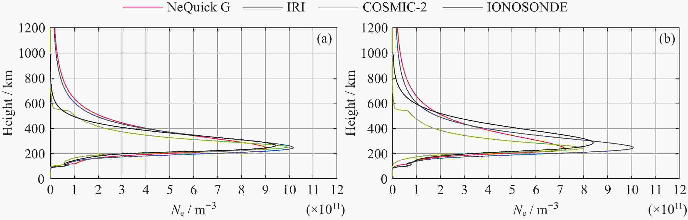
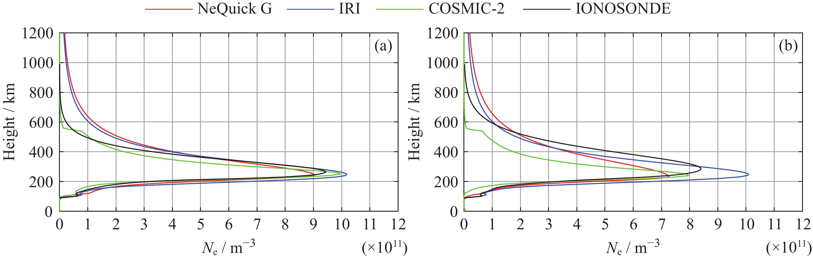
图 2 2021年11月3日 (a) 和4日 (b) 08:00 UT武汉站电离层模型剖面以及COSMIC-2掩星数据与测高仪剖面的对比
Figure 2. Comparison of ionospheric model profiles, COSMIC-2 radio occultation data, and ionosonde profiles at WU430 at 08:00 UT on 3 (a) and 4 (b) November 2021

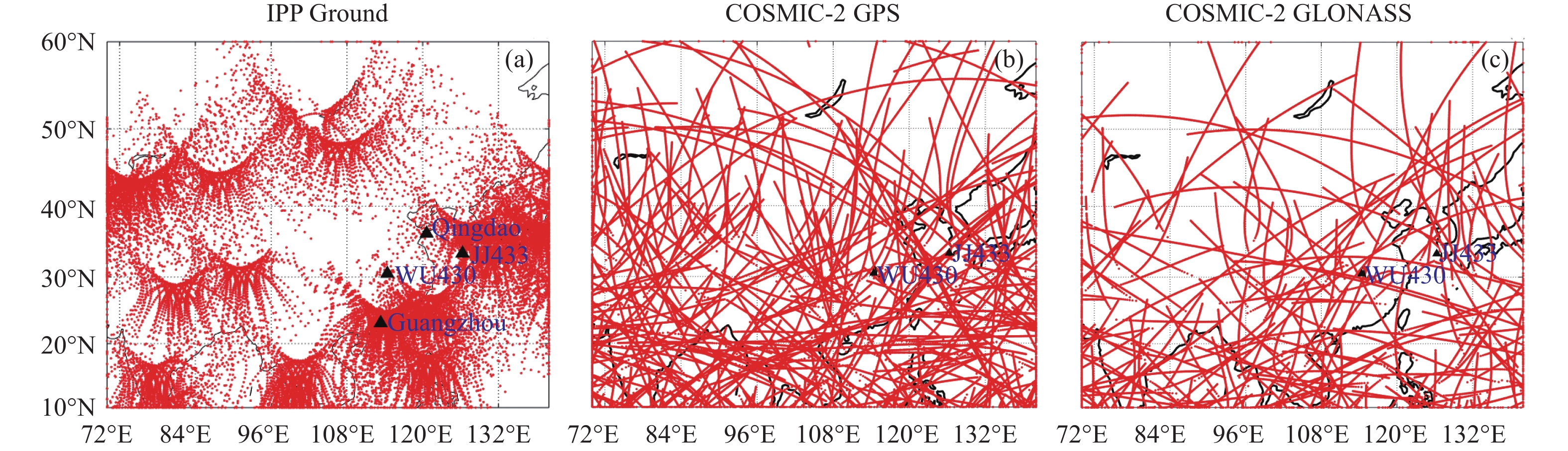
图 4 2021年11月4日 00:00 UT-24:00 UT地面测高仪站点分布以及地面GPS和掩星GPS/GLONASS IPP的轨迹
Figure 4. Distribution of four ionosondes and IPP trajectories of ground GPS and COSMIC-2 GPS/GLONASS between 00:00 UT and 24:00 UT on 4 November 2021
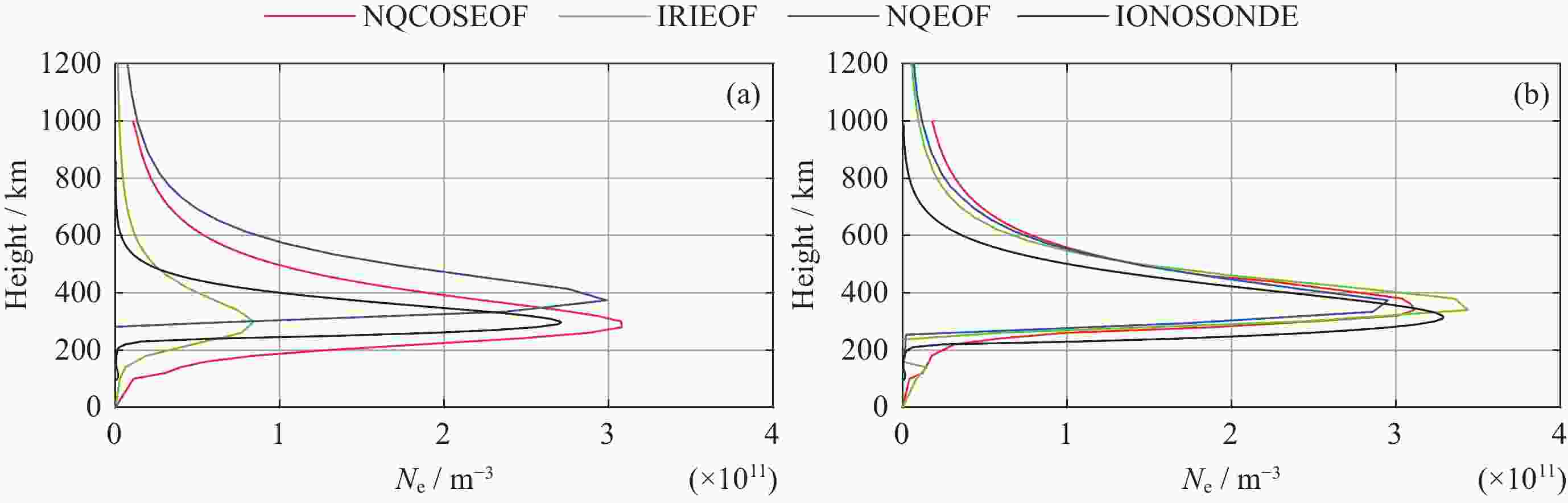
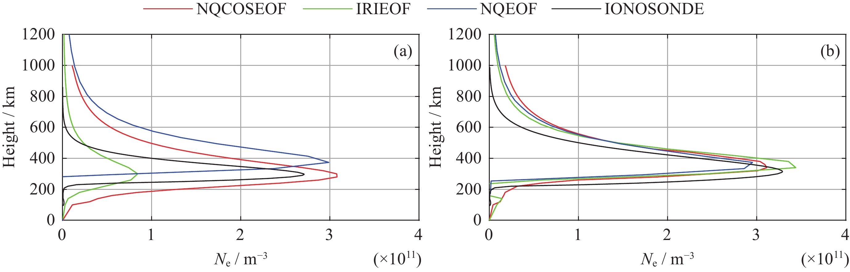
图 5 2021年11月3日 (a) 和4日 (b) 12:00 UT 武汉站不同EOF的层析剖面结果与测高仪剖面对比
Figure 5. Comparison of different EOF generated from profile results with ionosonde profiles at WU430 station at 12:00 UT on 3 (a) and 4 (b) November 2021
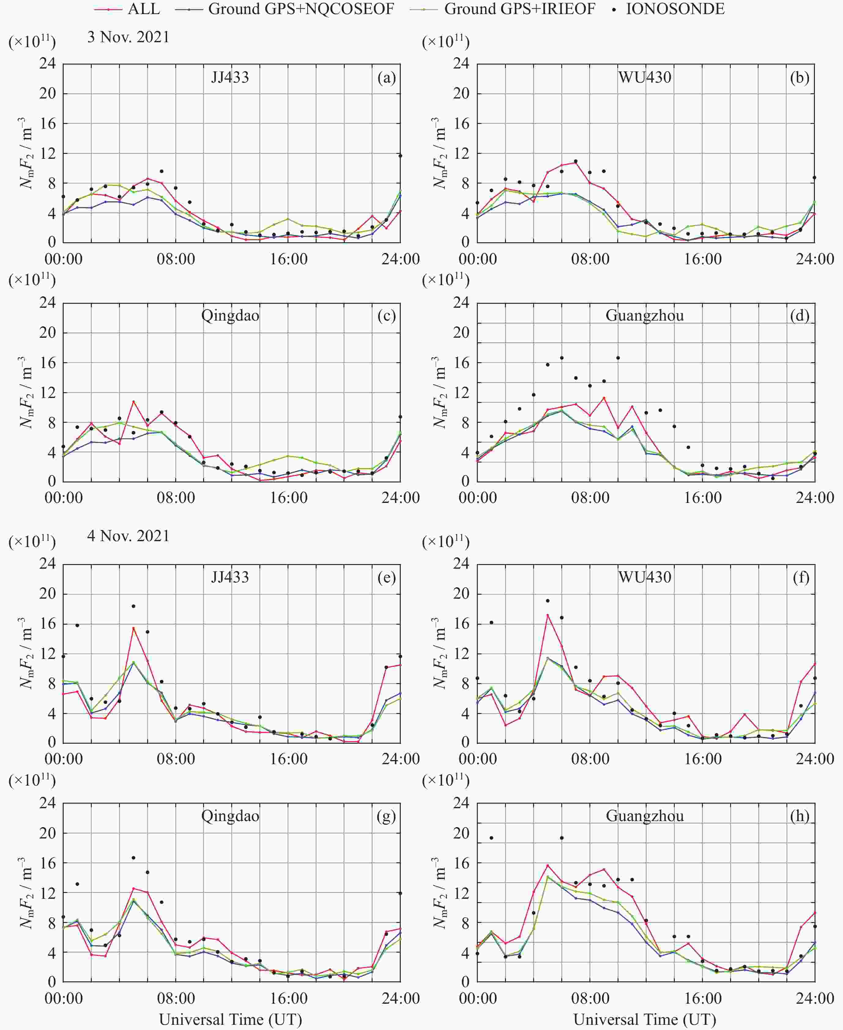
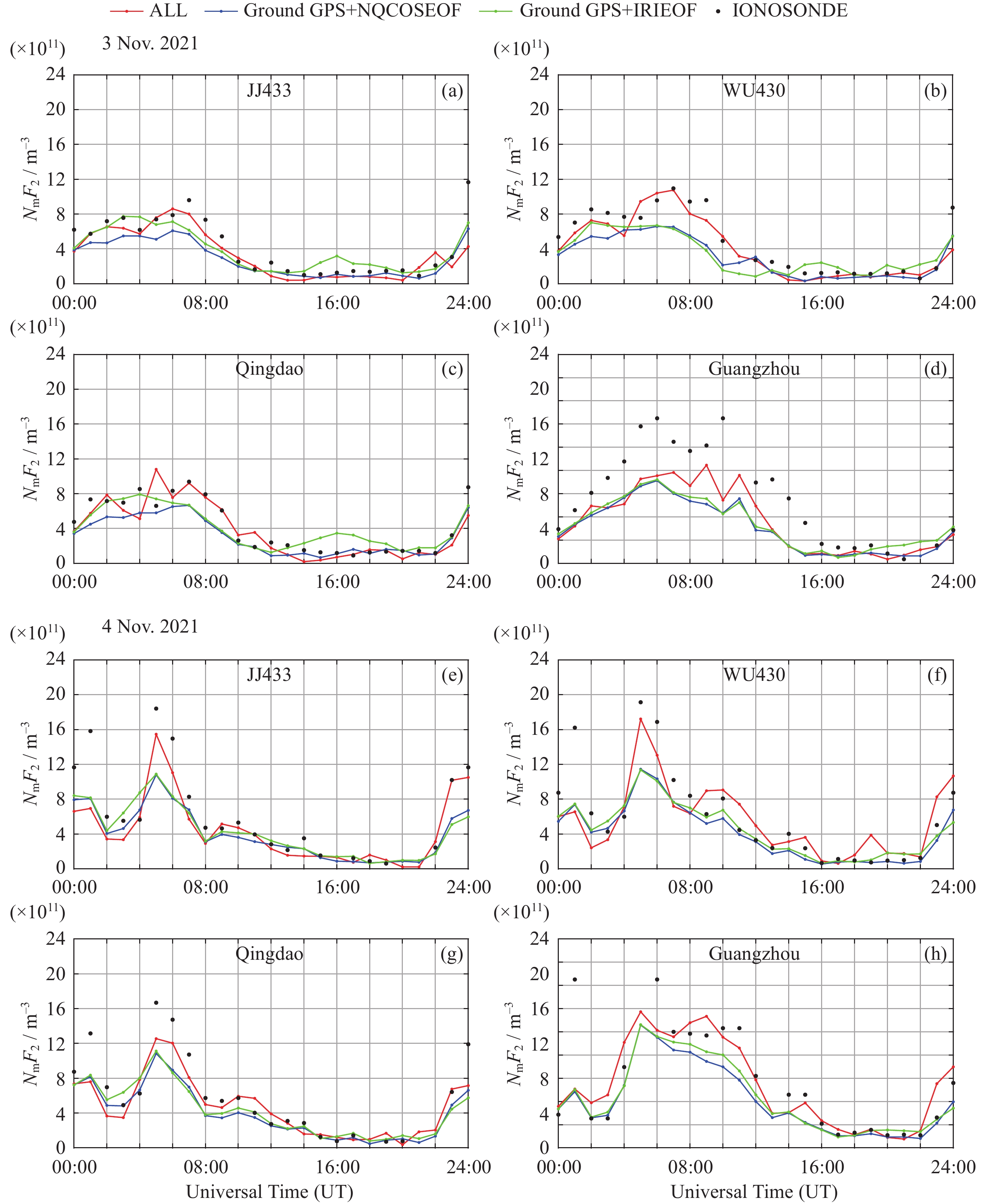
图 6 2021年11月3日和4日基于不同输入数据的层析结果与测高仪NmF2的对比
Figure 6. Comparison between tomographic results with different input data and ionosonde NmF2 on 3 and 4 November 2021
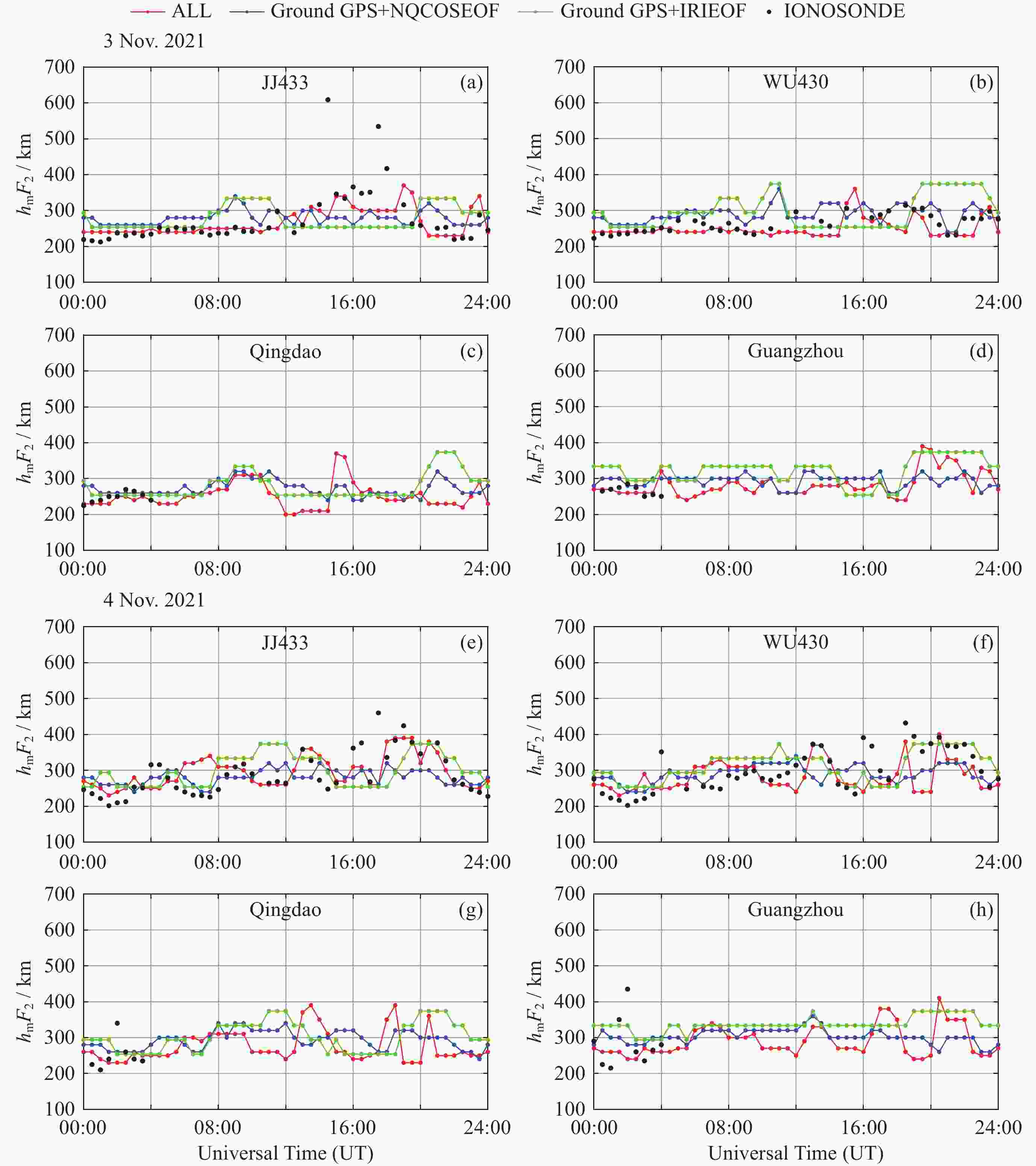
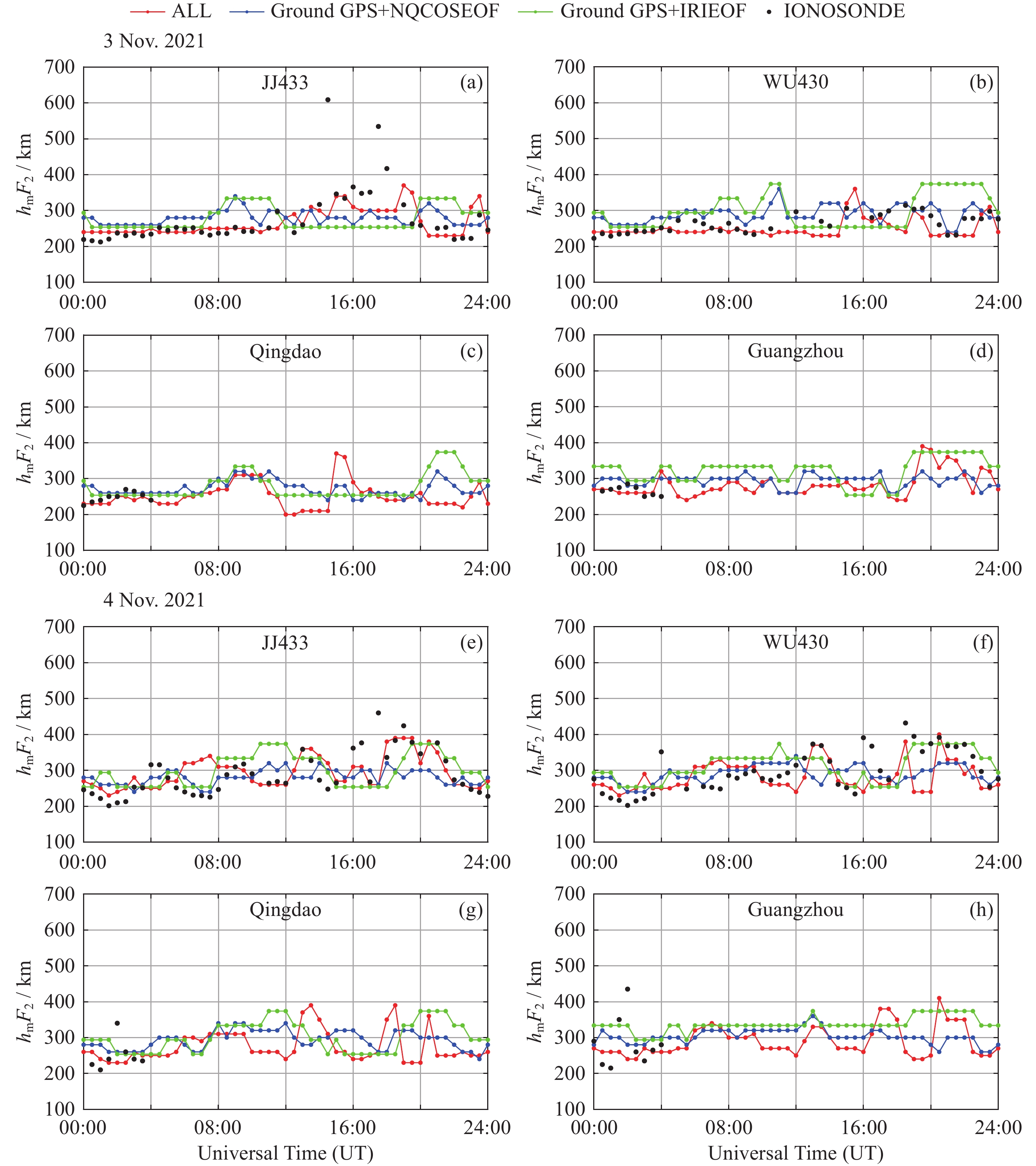
图 7 2021年11月3日和4日基于不同输入数据的层析结果与测高仪hmF2对比
Figure 7. Comparison between tomographic results with different input data and ionosonde hmF2 on 3 and 4 November 2021
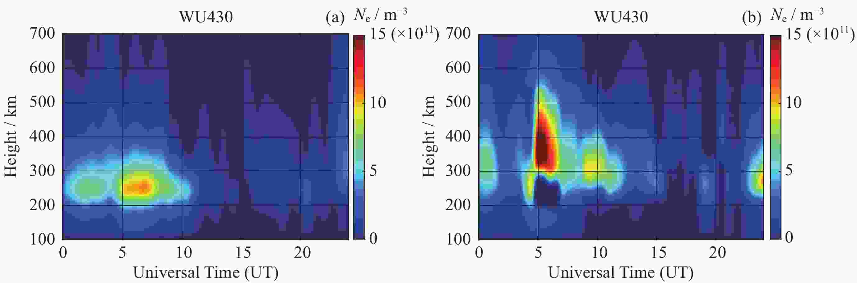
图 8 2021年11月3日 (a) 和4日 (b) 电子密度随时间和高度的分布
Figure 8. Changes of electron density with time and height on 3 (a) and 4 (b) November 2021
表 1 2021年11月3日和4日层析结果与测高仪NmF2误差 (单位: 1011 × m–3)
Table 1. NmF2 errors between tomographic results and ionosonde data on 3 and 4 November 2021 (Unit: 1011 ×m–3)
日期 站点 地基GPS+IRIEOF 地基GPS+NQCOSEOF 多源+NQCOSEOF(有输入数据时间段) Mean RMSE Mean RMSE RMSE改进
百分比/(%)Mean RMSE RMSE改进
百分比/(%)2021-11-03 JJ433 1.13 1.57 1.42 1.91 ― 1.22 1.8 ― WU430 1.94 2.28 1.95 2.30 ― 1.24 1.58 30.7 Qingdao 1.19 1.43 1.25 1.57 ― 1.09 1.49 ― Guangzhou 6.07 7.68 6.14 7.77 ― 5.04 6.37 17.0 2021-11-04 JJ433 2.38 3.38 2.32 3.30 2.37 1.81 2.68 20.7 WU430 1.94 3.01 1.97 3.01 ― 2.14 2.82 6.31 Qingdao 2.04 2.77 1.91 2.66 3.97 1.74 2.25 18.77 Guangzhou 3.87 6.09 4.22 6.40 ― 3.60 5.63 7.55  下载: 导出CSV
表 2 2021年11月3日和4日层析结果与测高仪hmF2误差 (单位: km)
Table 2. hmF2 errors between tomographic results and ionosonde data on 3 and 4 November 2021 (Unit: km)
日期 站点 地基GPS+IRIEOF 地基GPS+NQCOSEOF 多源+NQCOSEOF(有输入数据时间段) Mean RMSE Mean RMSE RMSE改进
百分比/(%)Mean RMSE RMSE改进
百分比/(%)2021-11-03 JJ433 53.21 66.26 45.20 51.79 21.84 24.31 35.62 46.24 WU430 53.64 65.65 28.49 33.34 49.22 19.57 26.78 59.21 Qingdao 16.82 25.57 20 26.25 ― 10 13.33 47.87 Guangzhou 48.17 53.78 28.13 32.06 40.39 18.13 27.67 50.41 2021-11-04 JJ433 49.27 64.56 46.53 58.52 9.36 36.41 52.36 18.90 WU430 42.38 51.36 44.60 54.80 ― 42.37 57.68 ― Qingdao 47.34 56.90 38.57 47.43 16.64 35.71 47.58 16.28 Guangzhou 58.22 69.91 57.22 72.21 ― 51.67 75.88 ―
下载: 导出CSV
-
[1] 胡嘉宇, 甘呈坤, 辜声峰. CSES/FY3C掩星与数字测高仪探测电离层特征参数比较分析[J]. 导航定位学报, 2023, 11(4): 120-129HU Jiayu, GAN Chengkun, GU Shengfeng. Comparative analysis of ionospheric characteristic parameters detected by CSES/FY3C occultation and ionosonde[J]. Journal of Navigation and Positioning, 2023, 11(4): 120-129 [2] YASYUKEVICH Y V, ZATOLOKIN D, PADOKHIN A, et al. Klobuchar, NeQuickG, BDGIM, GLONASS, IRI-2016, IRI-2012, IRI-Plas, NeQuick2, and GEMTEC ionospheric models: a comparison in total electron content and positioning domains[J]. Sensors, 2023, 23(10): 4773 doi: 10.3390/s23104773 [3] European Union. New Version of the Galileo Open Service Signal in Space Interface Control Document Now Available[R]. European Union: OS SIS ICD, 2023 [4] LEITINGER R, NAVA B, RADICELLA S. Electron density models for assessment studies - new developments[J]. Acta Geodaetica et Geophysica Hungarica, 2002, 37(2/3): 183-193 doi: 10.1556/AGeod.37.2002.2-3.7 [5] GUO Meijun, XU Longxia, REN Feilong, et al. Analysis of GPS/Galileo ionospheric model accuracy[C]//Academic Exchange Center of China Satellite Navigation System Management Office Proceedings of the 14th China Satellite Navigation Annual Conference——S02 Satellite Navigation System and Enhancement. Xi’an: Xi’an Aerospace Tianhui Data Technology Co, Ltd; National Time Service Center of the Chinese Academy of Sciences, 2024 [6] NIBIGIRA J D D, RATNAM V D, SIVAKRISHNA K. Performance analysis of NeQuick-G, IRI-2016, IRI-Plas 2017 and AfriTEC models over the African region during the geomagnetic storm of March 2015[J]. Geomagnetism and Aeronomy, 2023, 63(1): S83-S98 [7] 张震. 多GNSS掩星大气参数和边界层高度反演及质量评估[D]. 济南: 山东大学, 2022ZHANG Zhen. Inversion and Quality Evaluation of Atmospheric Parameters and ABLH of Multi GNSS Occultation Mission[D]. Jinan: Shandong University, 2022 [8] 张绍成, 虢盛, 郑沈宇, 等. COSMIC-2掩星观测与大气反演廓线质量分析[J]. 武汉大学学报(信息科学版), 2025, 50(3): 497-506ZHANG Shaocheng, GUO Sheng, ZHENG Shenyu, et al. Analysis of COSMIC-2 radio occultation observations and atmospheric profiles[J]. Geomatics and Information Science of Wuhan University, 2025, 50(3): 497-506 [9] DEAR R M, MITCHELL C N. Ionospheric imaging at mid-latitudes using both GPS and ionosondes[J]. Journal of Atmospheric and Solar-Terrestrial Physics, 2007, 69(7): 817-825 doi: 10.1016/j.jastp.2006.06.001 [10] MITCHELL C N, SPENCER P S J. A three-dimensional time-dependent algorithm for ionospheric imaging using GPS[J]. Annals of Geophysics, 2010, 46(4): 687-696 [11] YIN P, MITCHELL N C, SPENCER P S J, et al. Ionospheric electron concentration imaging using GPS over the USA during the storm of July 2000[J]. Geophysical Research Letters, 2004, 31(12): L12806 [12] YIN P, MITCHELL C N. Improving the vertical electron density profile in ionospheric imaging at storm time: a case study on 25-27 September 2011[J]. Journal of Geophysical Research Space Physics, 2014, 119(9): 7963-7971 doi: 10.1002/2014JA019899 [13] 李施佳, 蔡昌盛, 戴吾蛟, 等. 一种联合利用NeQuick模型和GPS数据的三维电离层重构方法[C]//第五届中国卫星导航学术年会论文集-S1北斗/GNSS导航应用. 南京: 中南大学地球科学与信息物理学院, 国网湖南省电力公司培训中心电力营销培训分部, 2014LI Shijia, CAI Changsheng, DAI Wujiao, et al. 3-Dimensional ionosphere reconstruction based on NeQuick model and GNSS data[C]//Proceedings of the 5th China Satellite Navigation Academic Annual Conference - S1 Beidou/GNSS Navigation Applications. Nanjing: School of Geoscience and Info-Physics, Central South Universit, Electric Power Marketing Department of Hunan Electrical Corporation Training Center, 2014 [14] JIN S G, LI D. 3-D ionospheric tomography from dense GNSS observations based on an improved two-step iterative algorithm[J]. Advances in Space Research, 2018, 62(4): 809-820 doi: 10.1016/j.asr.2018.05.032 [15] 欧明, 甄卫民, 徐继生, 等. 地基GPS与掩星联合的电离层层析成像方法研究[J]. 全球定位系统, 2014, 39(5): 1-7OU Ming, ZHEN Weimin, XU Jisheng, et al. Computerized ionospheric tomography combining with ground-based GPS and radio occultation[J]. GNSS World of China, 2014, 39(5): 1-7 [16] BRUNINI C, AZPILICUETA F, GENDE M, et al. Ground- and space-based GPS data ingestion into the NeQuick model[J]. Journal of Geodesy, 2011, 85(12): 931-939 doi: 10.1007/s00190-011-0452-4 [17] European Commission. European GNSS (Galileo) open service: ionospheric correction algorithm for Galileo single frequency users[EB/OL]. (2015)[2017-09-04] https://m2.cn.bing.com/search?q=European+GNSS+%28Galileo%29+open+service%3A+Ionospheric+correction+algorithm+for+galileo+single+frequency+users+%28issue+1.+2%29&search=&form=QBLH [18] 任丹丹. 基于kriging算法的WAAS电离层延迟估算研究[D]. 天津: 中国民航大学, 2020REN Dandan. Research for WAAS Ionospheric Delay Estimation Based on Kriging Algorithm[D]. Tianjin: Civil Aviation University of China, 2020 [19] 尹萍, 宁泽浩, 闫晓鹏. 基于BDS/GPS数据的中国及周边地区电离层暴层析成像研究[J]. 电波科学学报, 2022, 37(4): 653-662 doi: 10.12265/j.cjors.2021165YIN Ping, NING Zehao, YAN Xiaopeng. Imaging of the ionospheric storm over China and adjacent areas with BDS/GPS data[J]. Chinese Journal of Radio Science, 2022, 37(4): 653-662 doi: 10.12265/j.cjors.2021165 [20] 解海永, 宁百齐, 刘立波, 等. 北京地区电离层Chapman标高的统计分析[J]. 地球物理学报, 2014, 57(11): 3523-3531 doi: 10.6038/cjg20141104JIE Haiyong, NING Baiqi, LIU Libo, et al. Statistical analysis of the ionospheric Chapman scale height at Beijing[J]. Chinese Journal of Geophysics, 2014, 57(11): 3523-3531 doi: 10.6038/cjg20141104 [21] LIANG Yu, YIN Ping. The use of ionosonde and GPS COSMIC occultation data in ionospheric tomography[C]//Proceedings of the 14th China Satellite Navigation Annual Conference - S01 Satellite Navigation Applications, Beijing: Academic Exchange Center of China Satellite Navigation System Management Office, 2024 [22] 王金勇, 陈必焰, 曹恒瑞. 2017-09-07~08磁暴期间全球尺度电离层扰动[J]. 大地测量与地球动力学, 2023, 43(12): 1261-1268WANG Jinyong, CHEN Biyan, CAO Hengrui. Global scale ionospheric disturbance during the September 7—8, 2017 geomagnetic storm[J]. Journal of Geodesy and Geodynamics, 2023, 43(12): 1261-1268 [23] 明飞雄, 马锦山. 磁暴期间北斗GEO卫星电离层异常研究[J]. 地理空间信息, 2023, 21(8): 100-103 doi: 10.3969/j.issn.1672-4623.2023.08.026MING Feixiong, MA Jinshan. Study on ionospheric anomaly during geomagnetic storm by beidou GEO satellites[J]. Geospatial Information, 2023, 21(8): 100-103 doi: 10.3969/j.issn.1672-4623.2023.08.026 [24] 尹汇民, 孔建, 安家春, 等. 2017年9月强磁暴及引发的电离层扰动[J]. 地球物理学进展, 2021, 36(1): 96-104 doi: 10.6038/pg2021DD0484YIN Huimin, KONG Jian, AN Jiachun, et al. Strong geomagnetic storm and induced ionospheric disturbance in September 2017[J]. Progress in Geophysics, 2021, 36(1): 96-104 doi: 10.6038/pg2021DD0484 -
-

 下载:
下载:


计量
- 文章访问数: 1159
- HTML全文浏览量: 461
- PDF下载量: 149
-
被引次数:
0(来源:Crossref)
0(来源:其他)

