


卫星测高重力与船测重力协同融合的全球高分辨率海洋重力场模型
doi: 10.11728/cjss2026.03.2025-0138 cstr: 32142.14.cjss.2025-0138
-
 刘乾坤 男, 博士, 1995年8月出生于河南省项城市, 现为中国科学院国家空间科学中心项目高级工程师, 主要研究方向为卫星测高定量处理与应用、海洋重力场和海洋地形反演与建模等. E-mail: liuqiankun@nssc.ac.cn
-
 许可 男, 1967年3月出生于辽宁省盖州市, 现为中国科学院国家空间科学中心研究员、博士生导师, 主要研究方向为卫星雷达高度计系统技术、合成孔径雷达高度计系统技术、先进星载主动微波定量遥感探测技术、微波遥感信息处理与应用等. E-mail: xuke@mirslab.cn
通讯作者:
Global High-resolution Marine Gravity Field Model Fused from Altimetry-derived Gravity and Shipborne Gravity
-
摘要: 海洋重力场是地球系统的重要物理场, 船测重力与卫星测高重力是其高分辨率建模的主要数据源, 然而, 船测重力数据的空间覆盖在全球范围内稀疏且不均匀, 单一测高重力模型在特定区域往往存在精度局限或覆盖不全的问题. 本文利用西太平洋海域(120°E-170°E, 0°-50°N) JAMSTEC高密度船测重力数据, 基于国际上两大测高重力场系列模型的新版本DTU21和SIOv32.1, 建立重力模型误差与SRTM15v2.4水深的对应关系, 通过对两个模型进行加权融合, 并对极区进行特殊处理, 生成全球1'×1' 网格海洋重力异常模型FUSION_V1.0. 该模型包含经度、纬度和重力异常变量, 覆盖全球海洋(90°S-90°N, 180°W-180°E), 采用最为简单通用的地理坐标系统(即等经纬度投影), 以NetCDF格式存储, 支持主流科研软件读取. 本数据集可为海底地形反演、海洋地球物理研究和空间科学应用提供高质量基础数据.Abstract: The marine gravity field is a crucial physical field of the Earth system, with shipborne and satellite altimetry-derived gravity data serving as the primary sources for its high-resolution modeling. However, shipborne gravity data is sparsely and unevenly distributed globally, while single altimetry-derived gravity models exhibit accuracy limitations or incomplete coverage in specific regions. This study utilized high-density shipborne gravity data from the Japan Agency for Marine-Earth Science and Technology (JAMSTEC) in the western Pacific Ocean (120°E-170°E, 0°-50°N). Based on the latest versions of two major global altimetry-derived gravity field models, DTU21 and SIOv32.1, it establishes correlations between the gravity model errors verified by shipborne gravity and water depths from SRTM15v2.4 model. Through weighted fusion and special processing for polar regions, a global 1'×1' gridded marine gravity anomaly model, FUSION_V1.0, was generated. This model includes longitude, latitude, and gravity anomaly variables, covering the global ocean (90°S-90°N, 180°W-180°E) and adopting the simplest and most widely used geographic coordinate system (i.e., equiangular projection), stored in NetCDF format for compatibility with mainstream scientific software. This dataset can provide high-quality foundational data for seafloor topography recovery, marine geophysical research, and related space science applications.
-
Key words:
- Marine gravity field /
- Satellite altimetry /
- Ship gravity /
- Multi-source fusion /
- Gravity anomaly /
- Water depth /
- Global grid
-
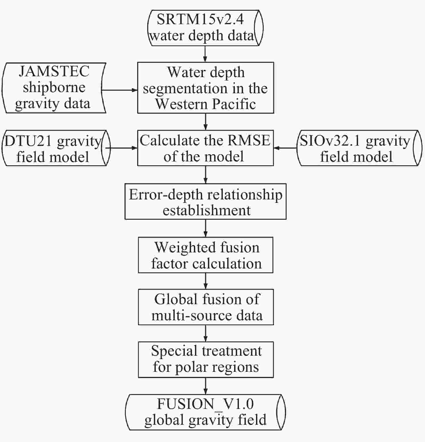
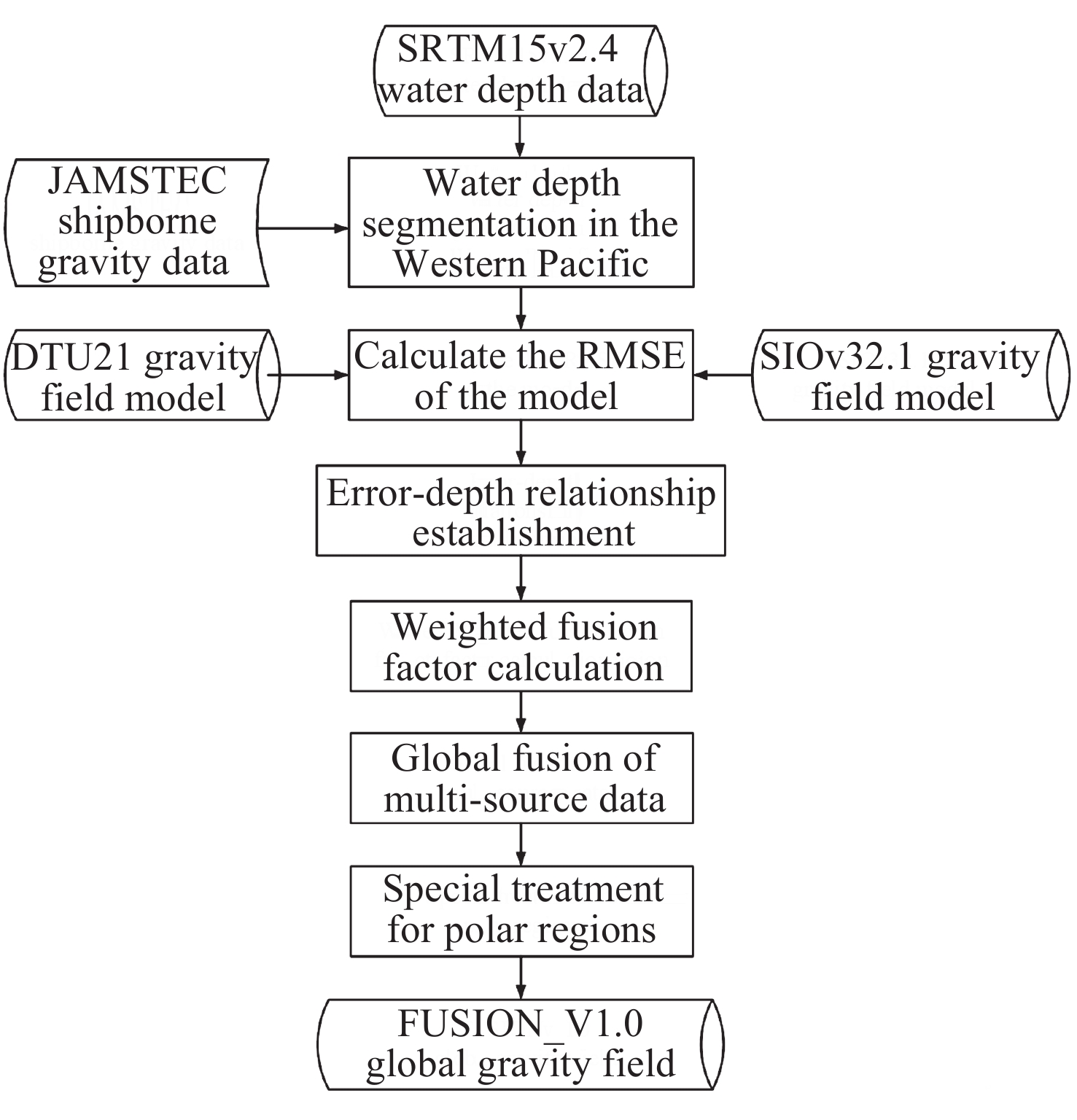
图 1 全球重力场融合模型FUSION_V1.0构建流程
Figure 1. Flow chart of the construction of the global gravity field fusion model FUSION_V1.0
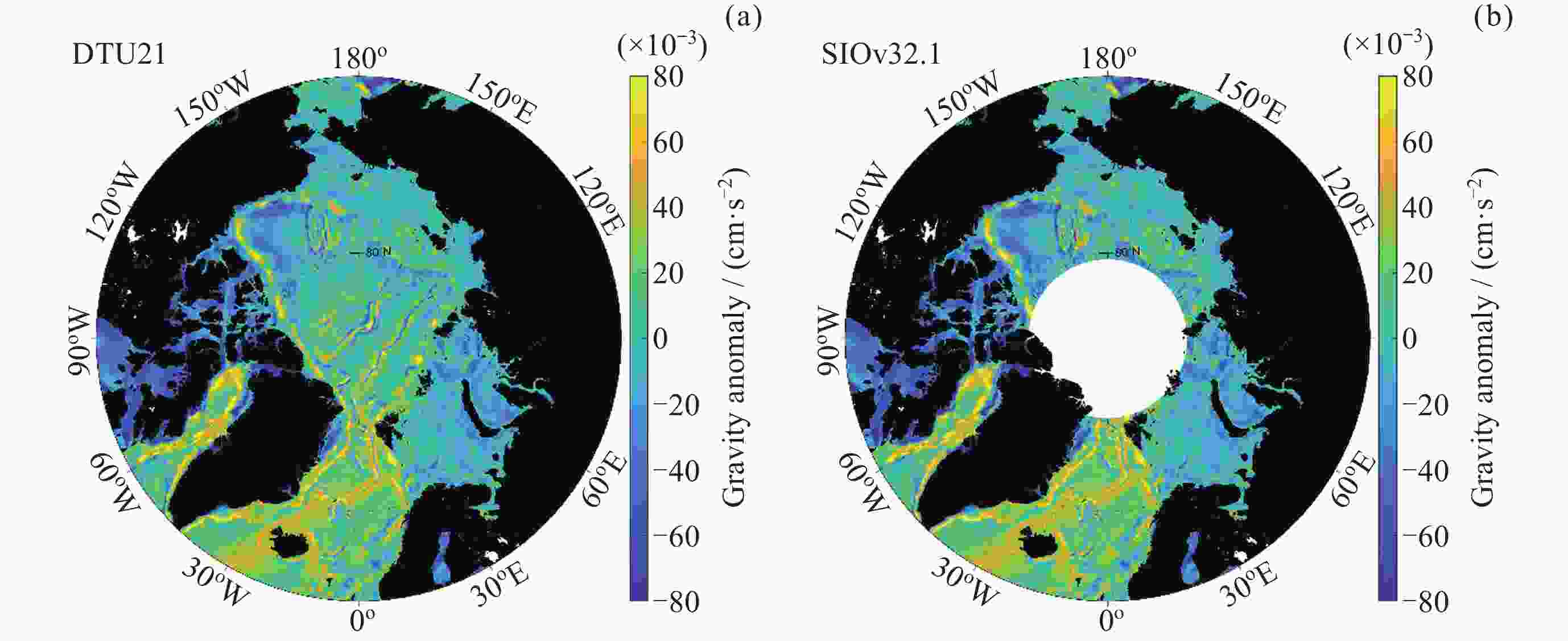
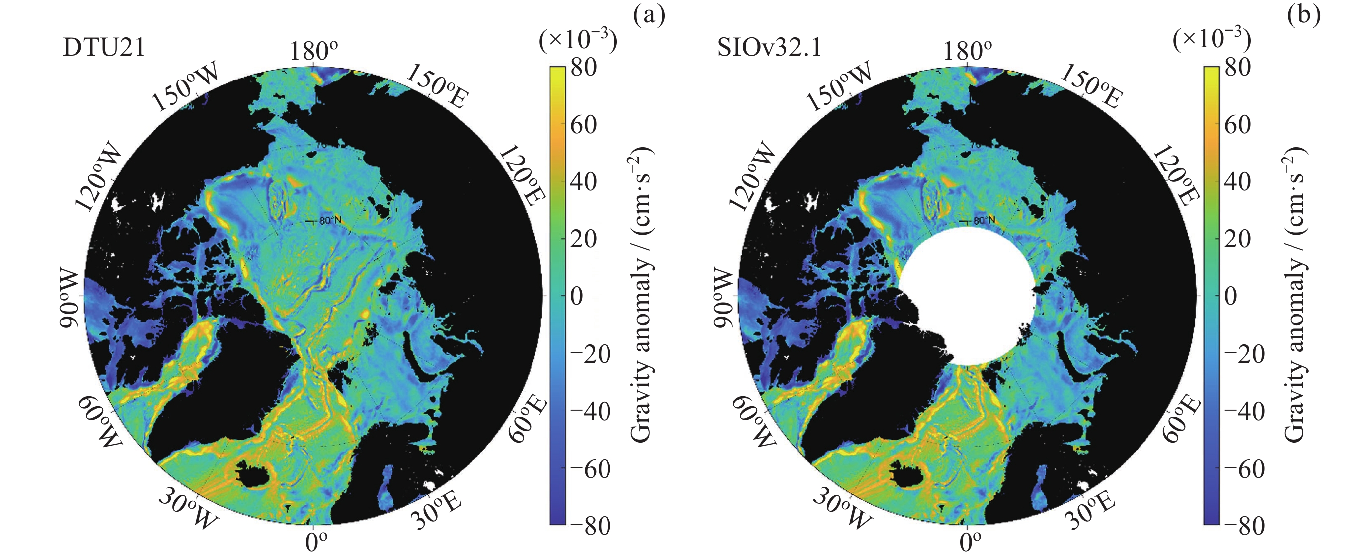
图 2 DTU21重力场和SIOv32.1重力场数据在北极区域的覆盖情况
Figure 2. Coverage of DTU21 gravity field and SIOv32.1 gravity field data in the Arctic region
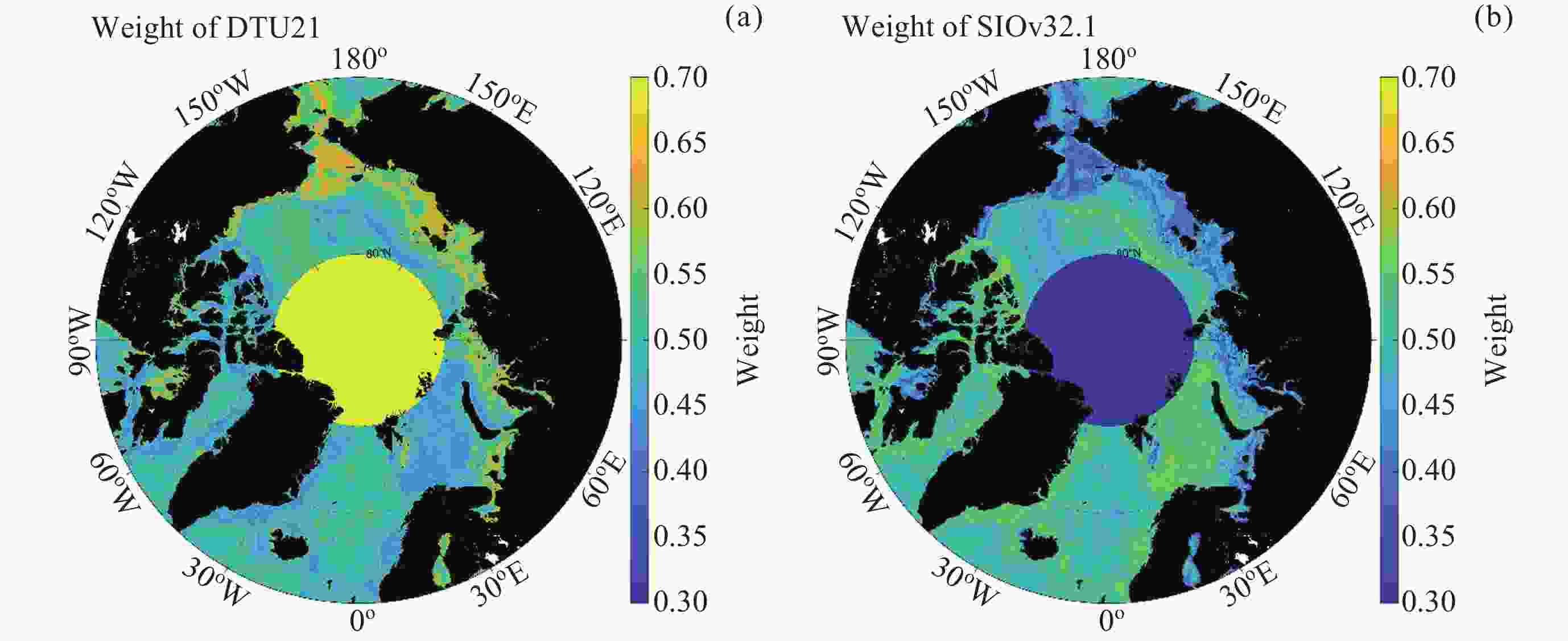
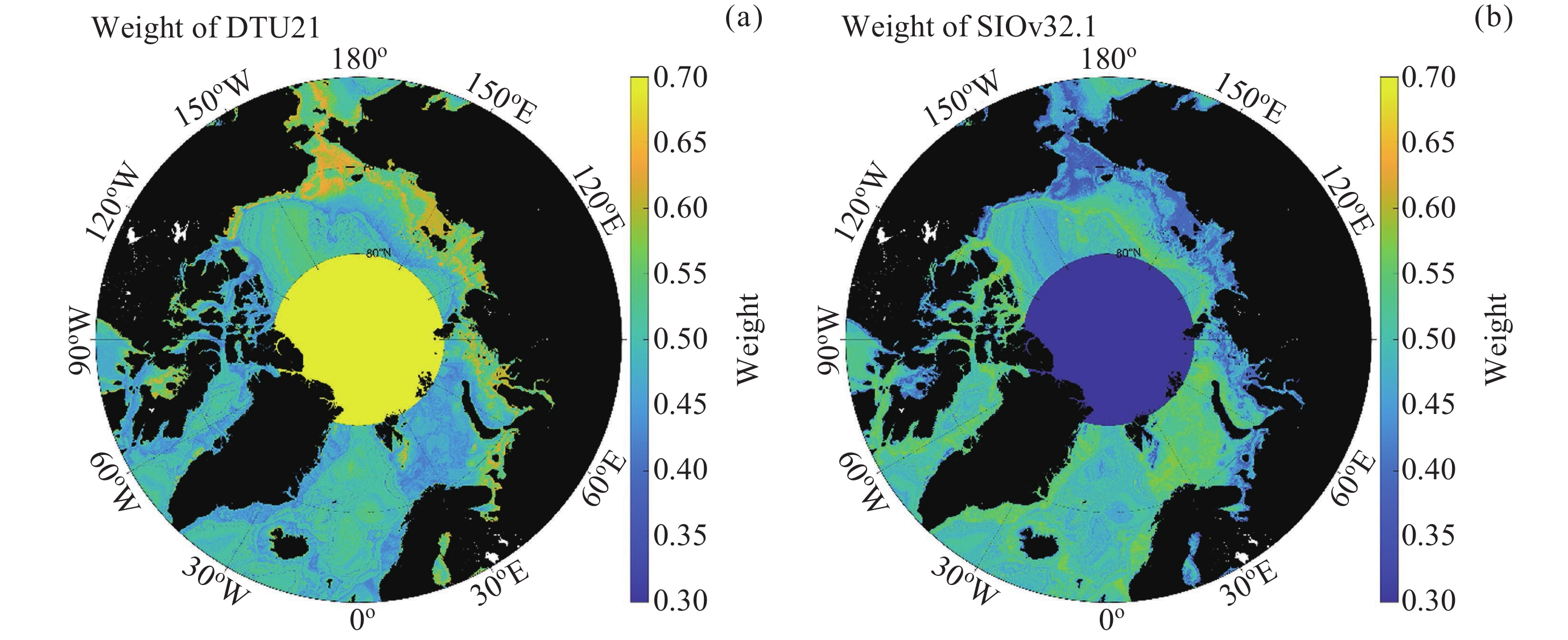
图 3 DTU21重力场和SIOv32.1重力场数据在北极区域的融合权重分布
Figure 3. Distribution of the fusion weights of DTU21 and SIOv32.1 gravity field data in the Arctic region

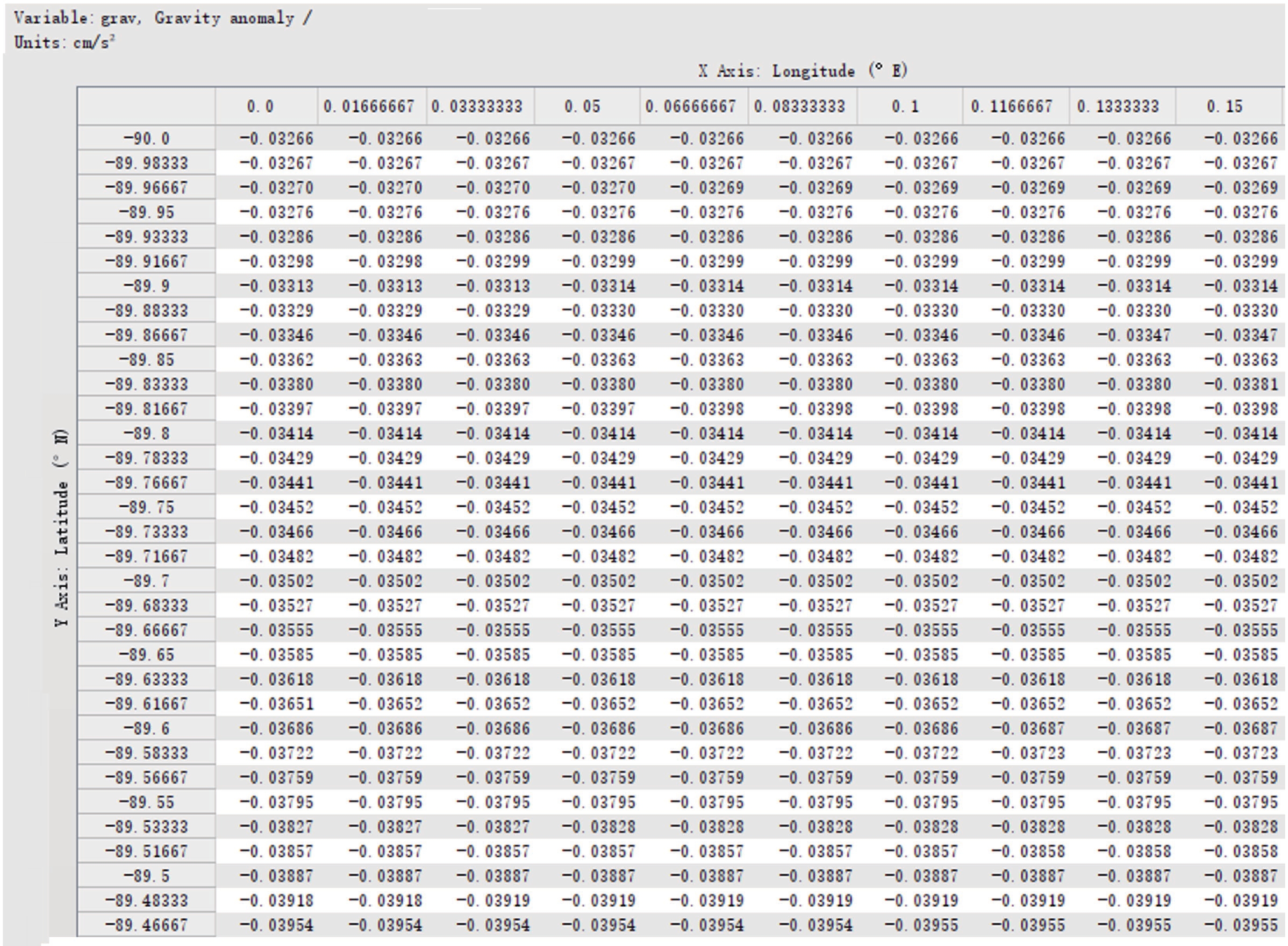
图 4 全球重力场融合模型FUSION_V1.0的数据结构
Figure 4. Data structure of the global gravity field fusion model FUSION_V1.0
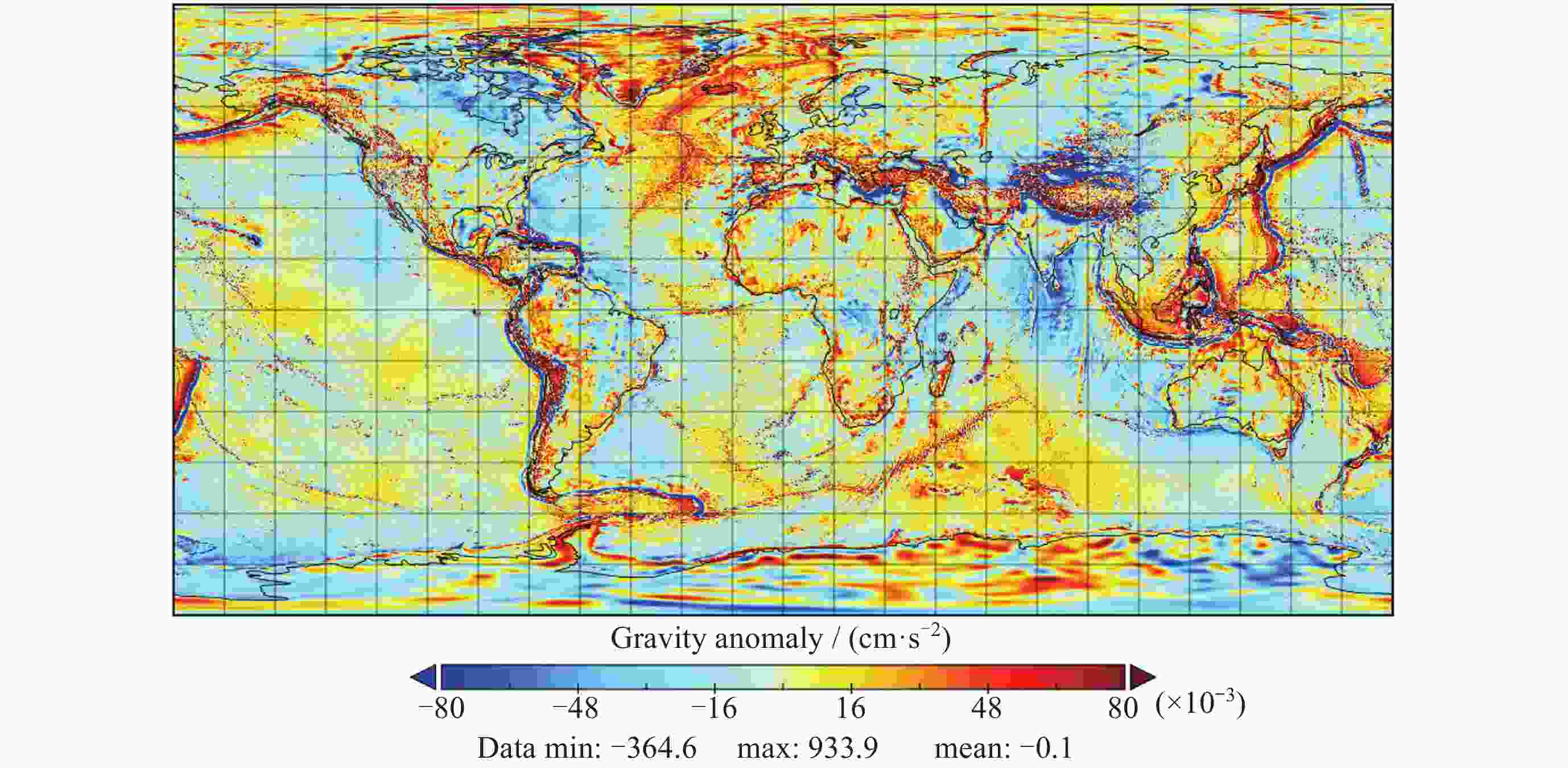
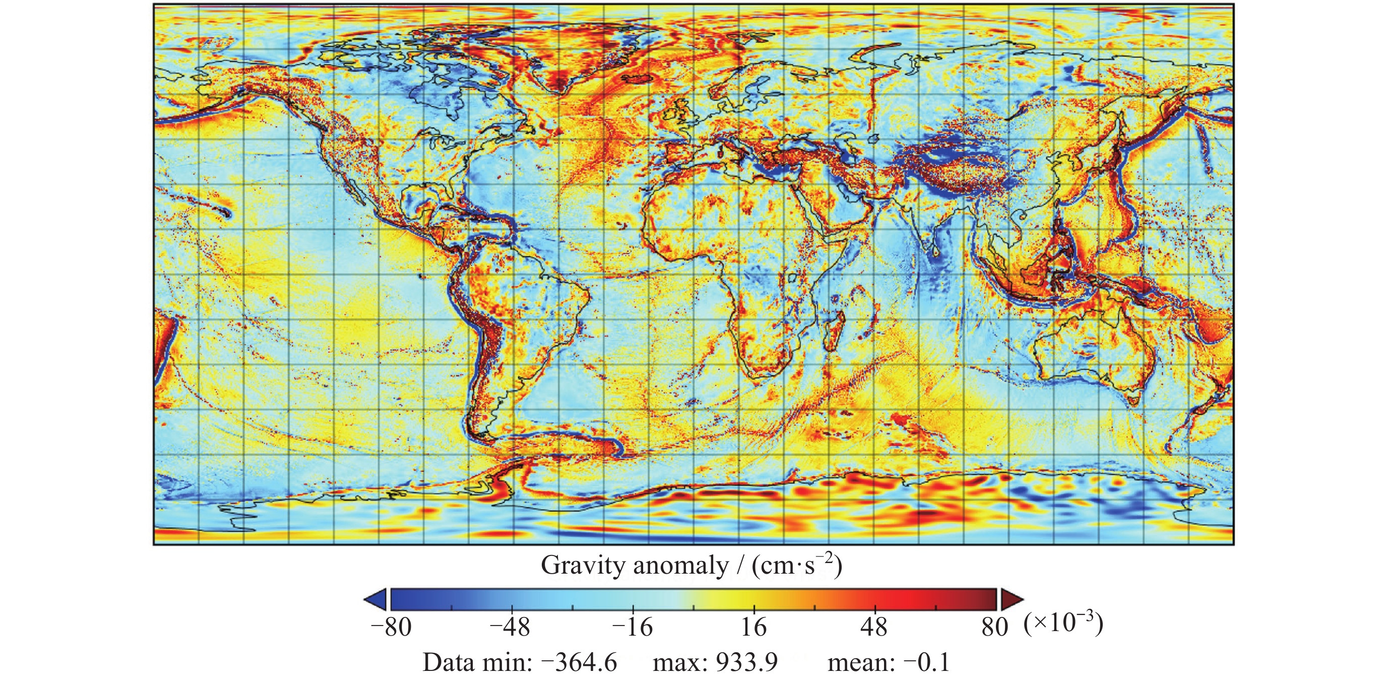
图 5 全球重力场融合模型FUSION_V1.0的二维重力异常网格
Figure 5. 2D gravity anomaly mesh of the global gravity field fusion model FUSION_V1.0
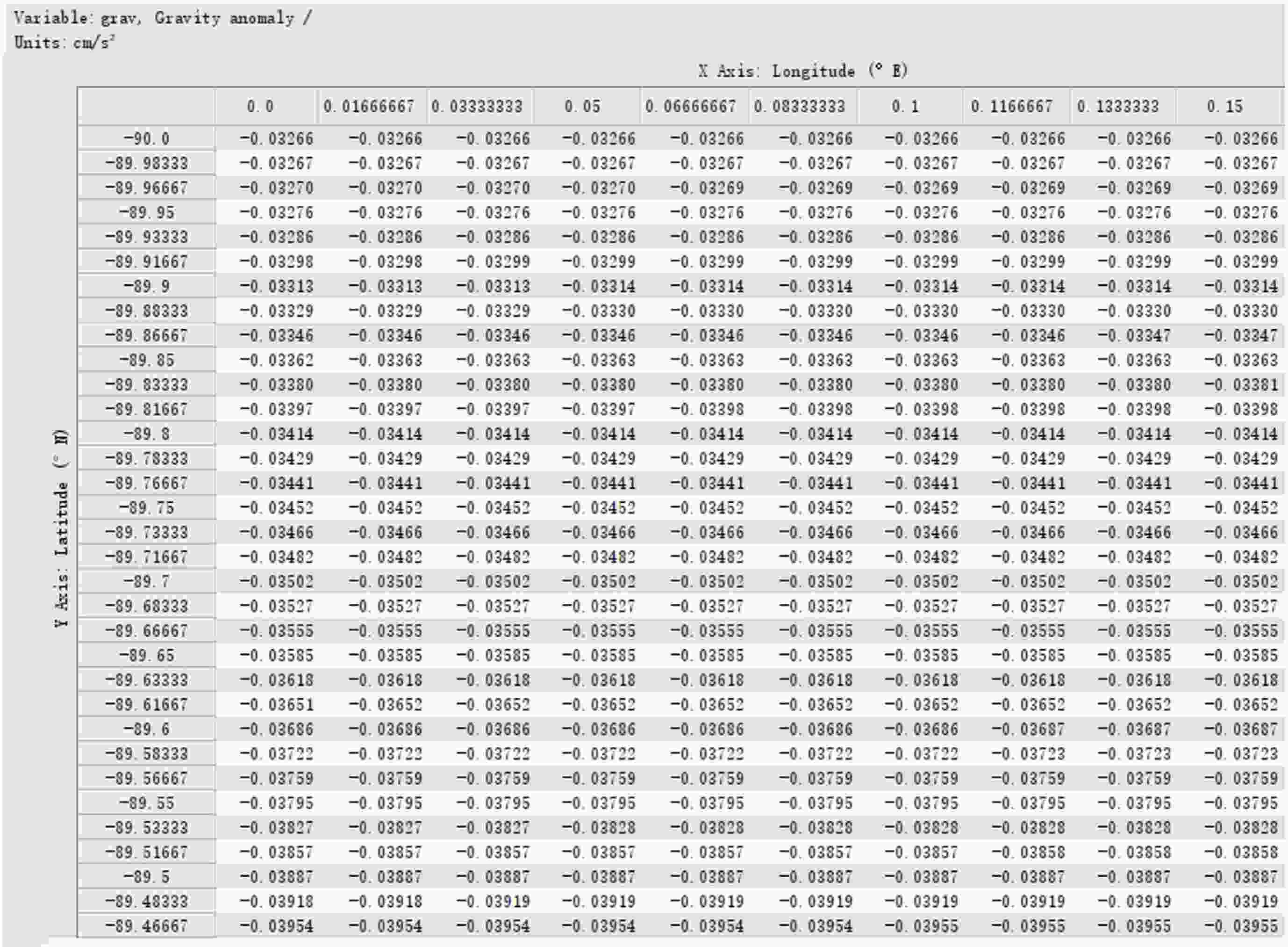
图 6 全球重力场融合模型FUSION_V1.0的grav样本示例
Figure 6. Sample example of grav of the global gravity field fusion model FUSION_V1.0
表 1 中国南海区域NCEI船测重力验证精度统计值(× 10–3, 单位: cm·s–2)
Table 1. Statistics of NCEI ship gravity verification values in the South China Sea region (× 10–3, Unit: cm·s–2)
Model max min mean STD RMS DTU21 14.74 –15.91 0.02 3.44 3.44 SIO V32 25.55 –41.03 0.24 3.50 3.51 FUSION_V1.0 17.24 –26.00 0.13 3.29 3.29  下载: 导出CSV
表 2 夏威夷群岛区域NCEI船测重力验证精度统计值(× 10–3, 单位: cm·s–2)
Table 2. Statistics of NCEI ship gravity verification values over the Hawaiian Islands (× 10–3, Unit: cm·s–2)
Model max min mean STD RMS DTU21 12.48 –13.84 0.01 2.30 2.30 SIO V32 11.63 –11.29 –0.03 2.30 2.30 FUSION_V1.0 11.20 –10.99 –0.01 2.16 2.16
下载: 导出CSV
-
[1] HWANG C, CHANG E T Y. Seafloor secrets revealed[J]. Science, 2014, 346(6205): 32-33 doi: 10.1126/science.1260459 [2] 孙中苗, 管斌, 翟振和, 等. 海洋卫星测高及其反演全球海洋重力场和海底地形模型研究进展[J]. 测绘学报, 2022, 51(6): 923-934SUN Zhongmiao, GUAN Bin, ZHAI Zhenhe, et al. Research progress of ocean satellite altimetry and its recovery of global marine gravity field and seafloor topography model[J]. Acta Geodaetica et Cartographica Sinica, 2022, 51(6): 923-934 [3] GARCIA E S M, SANDWELL D T, BASSETT D. Outer trench slope flexure and faulting at Pacific basin subduction zones[J]. Geophysical Journal International, 2019, 218(1): 708-728 doi: 10.1093/gji/ggz155 [4] 郑伟, 付腾达, 李钊伟, 等. 潜器水下重力匹配导航研究进展[J]. 科学技术与工程, 2022, 22(18): 7721-7734 doi: 10.3969/j.issn.1671-1815.2022.18.001ZHENG Wei, FU Tengda, LI Zhaowei, et al. Progress of undersea gravity matching navigation[J]. Science Technology and Engineering, 2022, 22(18): 7721-7734 doi: 10.3969/j.issn.1671-1815.2022.18.001 [5] MAYER L, JAKOBSSON M, ALLEN G, et al. The Nippon Foundation—GEBCO seabed 2030 project: the quest to see the world’s oceans completely mapped by 2030[J]. Geosciences, 2018, 8(2): 63 doi: 10.3390/geosciences8020063 [6] 许可, 蒋茂飞. 海洋卫星雷达测高技术进展[J]. 空间科学学报, 2023, 43(6): 1036-1057 doi: 10.11728/cjss2023.06.2023-06-yg14XU Ke, JIANG Maofei. Advance in ocean satellite radar altimetry technology[J]. Chinese Journal of Space Science, 2023, 43(6): 1036-1057 doi: 10.11728/cjss2023.06.2023-06-yg14 [7] 刘乾坤. 基于HY-2A卫星雷达高度计数据的海洋重力场反演研究[D]. 北京: 中国科学院大学, 2021LIU Qiankun. Inversion of Ocean Gravity Field Based on HY-2A Radar Altimeter Data[D]. Beijing: University of Chinese Academy of Sciences, 2021 [8] PAVLIS N K, HOLMES S A, KENYON S C, et al. The development and evaluation of the Earth Gravitational Model 2008 (EGM2008)[J]. Journal of Geophysical Research: Solid Earth, 2012, 118(B4): B04406 doi: 10.1029/2011jb008916 [9] LIU Q K, CHEN Z Y, XU K. Marine gravity field model fusion method based on water depth: a case study of the South China sea[C]//2024 IEEE International Geoscience and Remote Sensing Symposium. Athens: IEEE, 2024: 6031-6033 [10] CHEN Z Y, LIU Q K, XU K, et al. Weighted fusion method of marine gravity field model based on water depth segmentation[J]. Remote Sensing, 2024, 16(21): 4107 doi: 10.3390/rs16214107 [11] 陈兆钰, 许可, 刘乾坤, 等. 一种基于水深的全球海洋重力场模型融合系统及方法: 中国, 202410392766.2[P]. 2024-07-09CHEN Zhaoyu, XU Ke, LIU Qiankun, et al. Global ocean gravity field model fusion system and method based on water depth: CN, 202410392766.2[P]. 2024-07-09 [12] LI Y, ZHOU J C, LI J B, et al. Global marine gravity from 27 cycles of SWOT satellite data: accuracy and spatial resolution evaluation[J]. Journal of Geodesy, 2025, 99(6): 51 doi: 10.1007/s00190-025-01972-4 [13] TOZER B, SANDWELL D T, SMITH W H F, et al. Global bathymetry and topography at 15 arc sec: SRTM15+[J]. Earth and Space Science, 2019, 6(10): 1847-1864 [14] ANDERSEN O B, KNUDSEN P. The DTU17 global marine gravity field: first validation results[C]//Proceedings of the International Review Workshop on Satellite Altimetry Cal/Val Activities and Applications on Fiducial Reference Measurements for Altimetry. Cham: Springer, 2019: 83-87 [15] SANDWELL D T, HARPER H, TOZER B, et al. Gravity field recovery from geodetic altimeter missions[J]. Advances in Space Research, 2021, 68(2): 1059-1072 doi: 10.1016/j.asr.2019.09.011 -
-

 下载:
下载:


计量
- 文章访问数: 1611
- HTML全文浏览量: 586
- PDF下载量: 126
-
被引次数:
0(来源:Crossref)
0(来源:其他)

