| Citation: | XU Ke, JIANG Maofei. Advance in Ocean Satellite Radar Altimetry Technology (in Chinese). Chinese Journal of Space Science, 2023, 43(6): 1036-1057 doi: 10.11728/cjss2023.06.2023-06-yg14

|

| [1] |
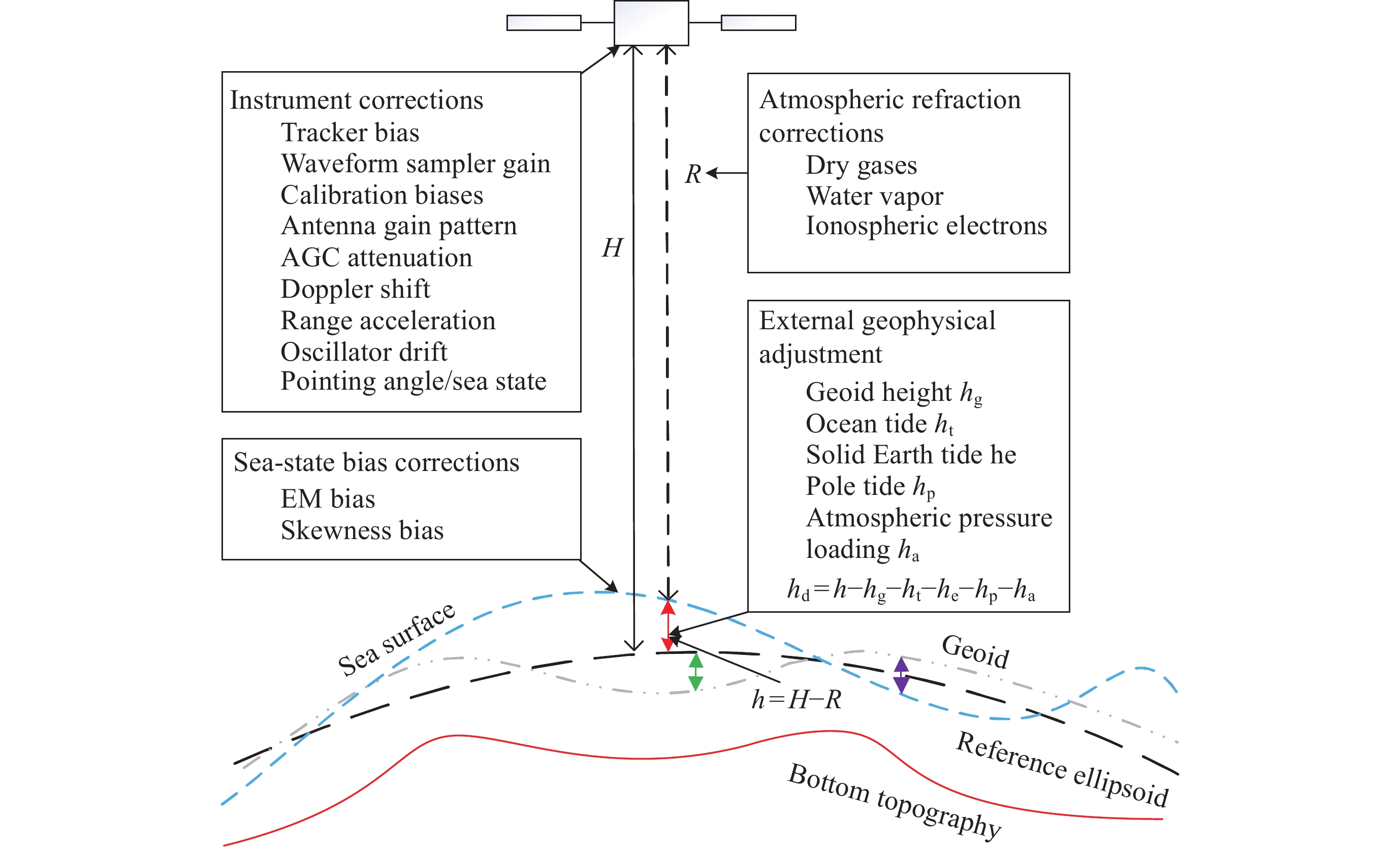
KAULA W M. The terrestrial environment: Solid-earth and ocean physics [EB/OL]. (1970-04-01)[2023-10-26]. https://ilrs.gsfc.nasa.gov/docs/williamstown_1968.pdf
|
| [2] |
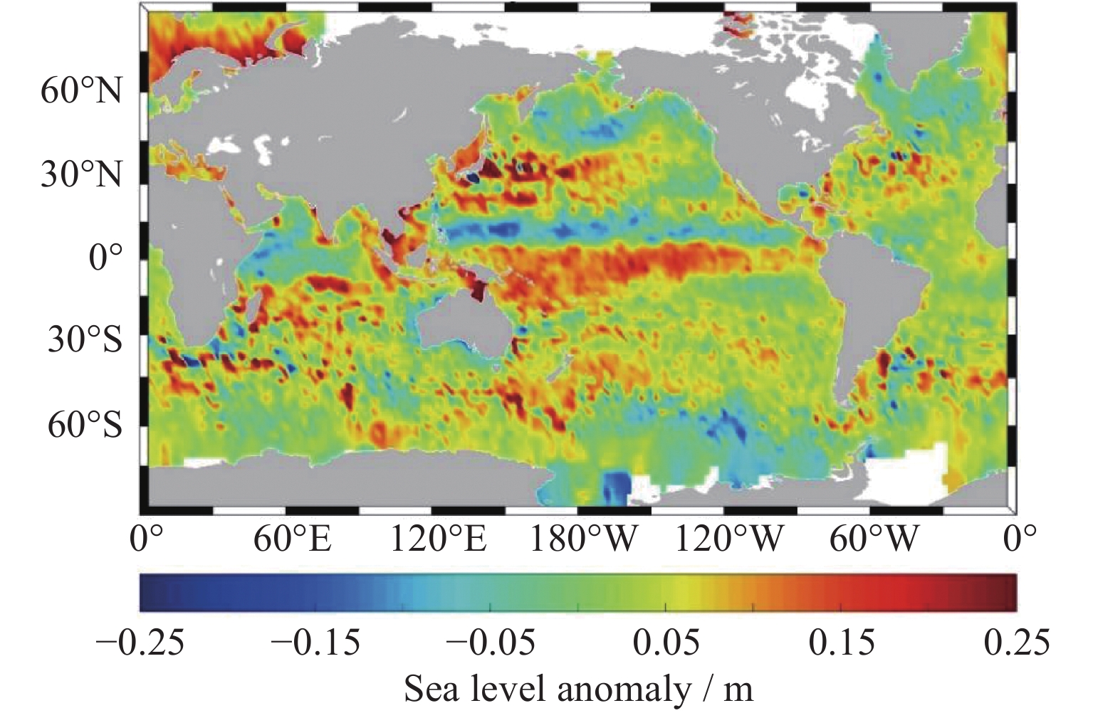
CAO Y H, DONG C M, QIU Z H, et al. Corrections of mesoscale eddies and Kuroshio extension surface velocities derived from satellite altimeters[J]. Remote Sensing, 2022, 15(1): 184 doi: 10.3390/rs15010184
|
| [3] |
DOGLIONI F, RICKER R, RABE B, et al. Sea surface height anomaly and geostrophic current velocity from altimetry measurements over the Arctic Ocean (2011-2020)[J]. Earth System Science Data, 2023, 15(1): 225-263 doi: 10.5194/essd-15-225-2023
|
| [4] |
MORROW R, LE TRAON P Y. Recent advances in observing mesoscale ocean dynamics with satellite altimetry[J]. Advances in Space Research, 2012, 50(8): 1062-1076 doi: 10.1016/j.asr.2011.09.033
|
| [5] |
WANG G H, SU J L, CHU P C. Mesoscale eddies in the South China Sea observed with altimeter data[J]. Geophysical Research Letters, 2003, 30(21): 2121
|
| [6] |
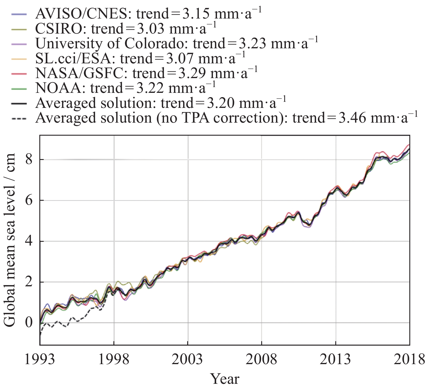
ABLAIN M, MEYSSIGNAC B, ZAWADZKI L, et al. Uncertainty in satellite estimates of global mean sea-level changes, trend and acceleration[J]. Earth System Science Data, 2019, 11(3): 1189-1202 doi: 10.5194/essd-11-1189-2019
|
| [7] |
CHEN X Y, ZHANG X B, CHURCH J A, et al. The increasing rate of global mean sea-level rise during 1993-2014[J]. Nature Climate Change, 2017, 7(7): 492-495 doi: 10.1038/nclimate3325
|
| [8] |
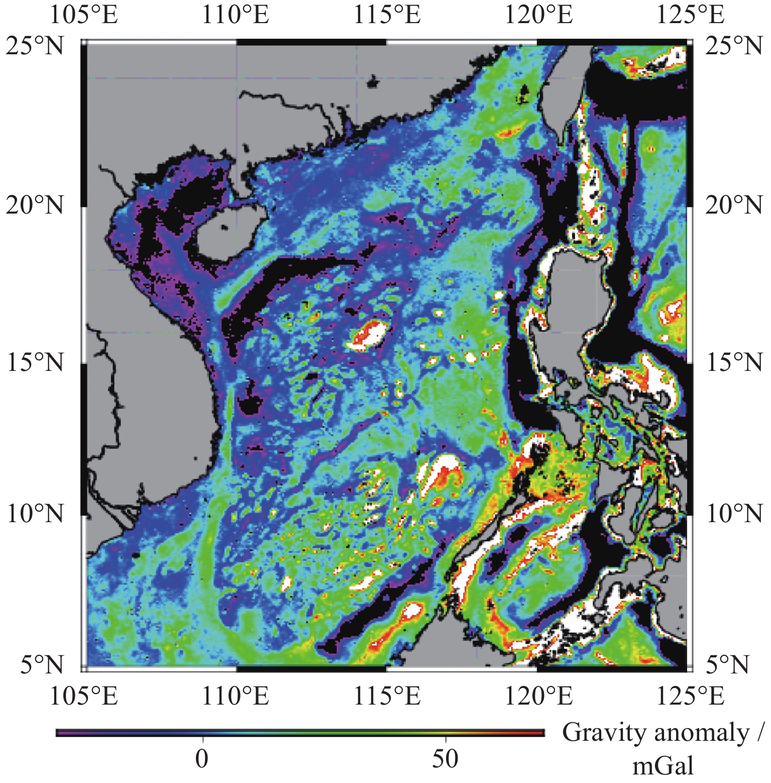
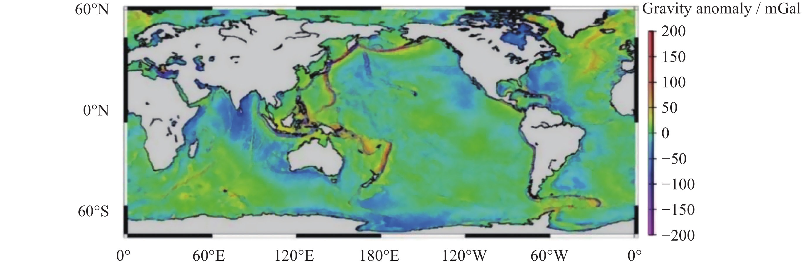
ZHU C C, GUO J Y, YUAN J J, et al. SDUST2021GRA: global marine gravity anomaly model recovered from Ka-band and Ku-band satellite altimeter data[J]. Earth System Science Data, 2022, 14(10): 4589-4606 doi: 10.5194/essd-14-4589-2022
|
| [9] |
SANDWELL D T, MÜLLER R D, SMITH W H F, et al. New global marine gravity model from CryoSat-2 and Jason-1 reveals buried tectonic structure[J]. Science, 2014, 346(6205): 65-67 doi: 10.1126/science.1258213
|
| [10] |
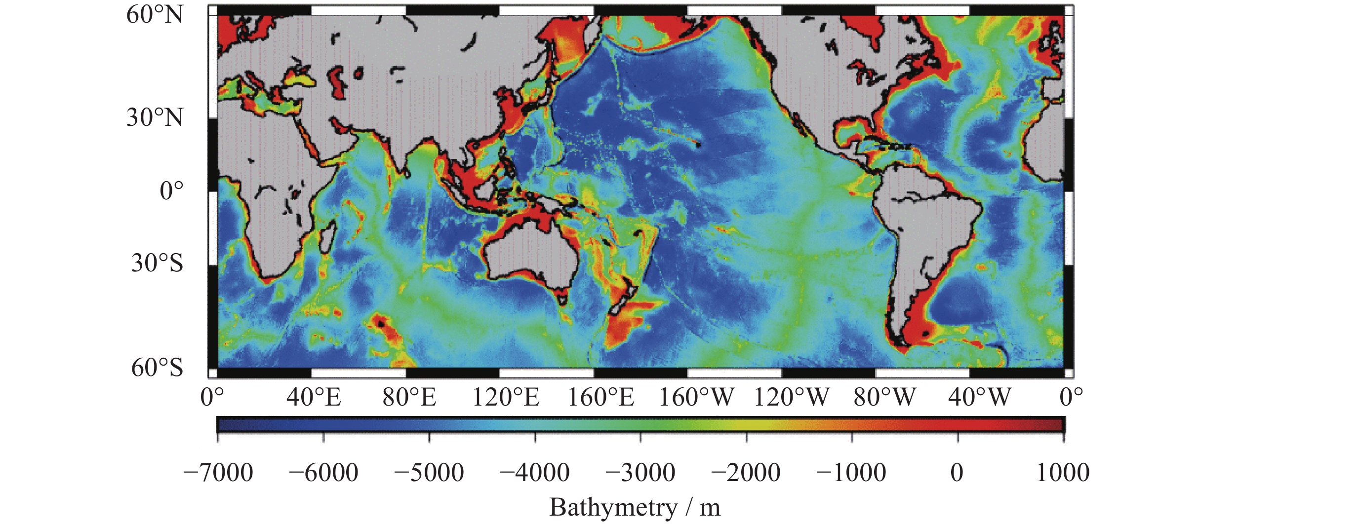
SMITH W H F, SANDWELL D T. Global sea floor topography from satellite altimetry and ship depth soundings[J]. Science, 1997, 277(5334): 1956-1962 doi: 10.1126/science.277.5334.1956
|
| [11] |
FAN D, LI S S, LI X X, et al. Seafloor topography estimation from gravity anomaly and vertical gravity gradient using nonlinear iterative least square method[J]. Remote Sensing, 2020, 13(1): 64 doi: 10.3390/rs13010064
|
| [12] |
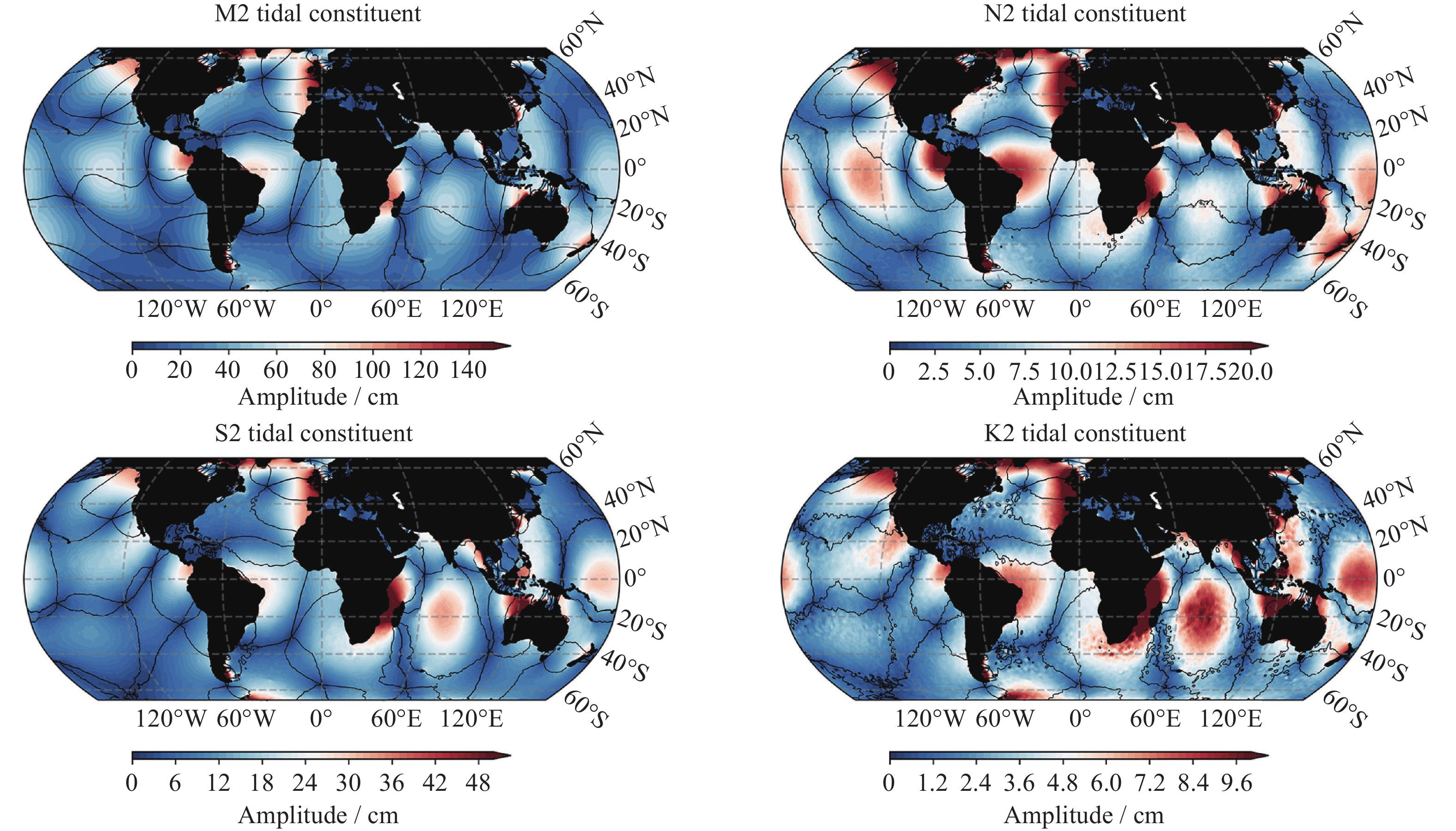
HART-DAVIS M G, PICCIONI G, DETTMERING D, et al. EOT20: a global ocean tide model from multi-mission satellite altimetry[J]. Earth System Science Data, 2021, 13(8): 3869-3884 doi: 10.5194/essd-13-3869-2021
|
| [13] |
LYARD F H, ALLAIN D J, CANCET M, et al. FES2014 global ocean tide atlas: design and performance[J]. Ocean Science, 2021, 17(3): 615-649 doi: 10.5194/os-17-615-2021
|
| [14] |
SLATER T, SHEPHERD A, MCMILLAN M, et al. A new digital elevation model of Antarctica derived from CryoSat-2 altimetry[J]. The Cryosphere, 2018, 12(4): 1551-1562 doi: 10.5194/tc-12-1551-2018
|
| [15] |
HELM V, HUMBERT A, MILLER H. Elevation and elevation change of Greenland and Antarctica derived from CryoSat-2[J]. The Cryosphere, 2014, 8(4): 1539-1559 doi: 10.5194/tc-8-1539-2014
|
| [16] |
LAXON S, PEACOCK N, SMITH D. High interannual variability of sea ice thickness in the arctic region[J]. Nature, 2003, 425(6961): 947-950 doi: 10.1038/nature02050
|
| [17] |
TILLING R L, RIDOUT A, SHEPHERD A. Estimating Arctic sea ice thickness and volume using CryoSat-2 radar altimeter data[J]. Advances in Space Research, 2018, 62(6): 1203-1225 doi: 10.1016/j.asr.2017.10.051
|
| [18] |
LIU G M, SCHWARTZ F, TSENG K H, et al. Satellite altimetry for measuring river stages in remote regions[J]. Environmental Earth Sciences, 2018, 77(18): 639 doi: 10.1007/s12665-018-7823-6
|
| [19] |
JIANG L G, NIELSEN K, ANDERSEN O B. Improvements in mountain lake monitoring from satellite altimetry over the past 30 years – lessons learned from Tibetan lakes[J]. Remote Sensing of Environment, 2023, 295: 113702 doi: 10.1016/j.rse.2023.113702
|
| [20] |
MCGOOGAN J T, MILLER L S, BROWN G S, et al. The S-193 radar altimeter experiment[J]. Proceedings of the IEEE, 1974, 62(6): 793-803 doi: 10.1109/PROC.1974.9519
|
| [21] |
MARSH J G, CHANG E S. Detailed gravimetric geoid confirmation of sea surface topography detected by the skylab S-193 altimeter in the Atlantic Ocean[J]. Journal of Geodesy, 1976, 50(3): 291-299 doi: 10.1007/BF02521967
|
| [22] |
RAPP D H. Geos 3 data processing for the recovery of geoid undulations and gravity anomalies[J]. Journal of Geophysical Research: Solid Earth, 1979, 84(B8): 3784-3792 doi: 10.1029/JB084iB08p03784
|
| [23] |
BAUER E, HASSELMANN S, HASSELMANN K, et al. Validation and assimilation of Seasat altimeter wave heights using the WAM wave model[J]. Journal of Geophysical Research: Oceans, 1992, 97(C8): 12671-12682 doi: 10.1029/92JC01056
|
| [24] |
HAXBY W F, WEISSEL J K. Evidence for small-scale mantle convection from Seasat altimeter data[J]. Journal of Geophysical Research: Solid Earth, 1986, 91(B3): 3507-3520 doi: 10.1029/JB091iB03p03507
|
| [25] |
MARSH J G, KOBLINSKY C J, ZWALLY H J, et al. A global mean sea surface based upon GEOS 3 and Seasat altimeter data[J]. Journal of Geophysical Research Solid Earth, 1992, 97(B4): 4915-4921 doi: 10.1029/91JB03153
|
| [26] |
SANDWELL D T, MCADOO D C. High-accuracy, high-resolution gravity profiles from 2 years of the Geosat exact repeat mission[J]. Journal of Geophysical Research: Oceans, 1990, 95(C3): 3049-3060 doi: 10.1029/JC095iC03p03049
|
| [27] |
TRAN N, HANCOCK III D W, HAYNE G S, et al. Assessment of the cycle-to-cycle noise level of the Geosat Follow-On, TOPEX, and poseidon altimeters[J]. Journal of Atmospheric and Oceanic Technology, 2002, 19(12): 2095-2107 doi: 10.1175/1520-0426(2002)019<2095:AOTCTC>2.0.CO;2
|
| [28] |
TAPLEY B D, RIES J C, DAVIS G W, et al. Precision orbit determination for TOPEX/POSEIDON[J]. Journal of Geophysical Research: Oceans, 1994, 99(C12): 24383-24404 doi: 10.1029/94JC01645
|
| [29] |
DORANDEU J, ABLAIN M, FAUGÈRE Y, et al. Jason-1 global statistical evaluation and performance assessment: Calibration and cross-calibration results[J]. Marine Geodesy, 2004, 27(3/4): 345-372
|
| [30] |
ABLAIN M, PHILIPPS S, PICOT N, et al. Jason-2 global statistical assessment and cross-calibration with Jason-1[J]. Marine Geodesy, 2010, 33(S1): 162-185
|
| [31] |
FAUGERE Y, DORANDEU J, LEFEVRE F, et al. Envisat ocean altimetry performance assessment and cross-calibration[J]. Sensors, 2006, 6(3): 100-130 doi: 10.3390/s6030100
|
| [32] |
BONNEFOND P, VERRON J, AUBLANC J, et al. The benefits of the Ka-Band as evidenced from the SARAL/AltiKa Altimetric mission: quality assessment and unique characteristics of AltiKa data[J]. Remote Sensing, 2018, 10(2): 83 doi: 10.3390/rs10010083
|
| [33] |
TOURNADRE J, LAMBIN-ARTRU J, STEUNOU N. Cloud and rain effects on AltiKa/SARAL Ka-band Radar altimeter—Part I: modeling and mean annual data availability[J]. IEEE Transactions on Geoscience and Remote Sensing, 2009, 47(6): 1806-1817 doi: 10.1109/TGRS.2008.2010130
|
| [34] |
TOURNADRE J, LAMBIN-ARTRU J, STEUNOU N. Cloud and rain effects on AltiKa/SARAL Ka-Band radar altimeter—Part II: definition of a rain/cloud flag[J]. IEEE Transactions on Geoscience and Remote Sensing, 2009, 47(6): 1818-1826 doi: 10.1109/TGRS.2008.2010127
|
| [35] |
RANEY R K. The delay/Doppler radar altimeter[J]. IEEE Transactions on Geoscience and Remote Sensing, 1998, 36(5): 1578-1588 doi: 10.1109/36.718861
|
| [36] |
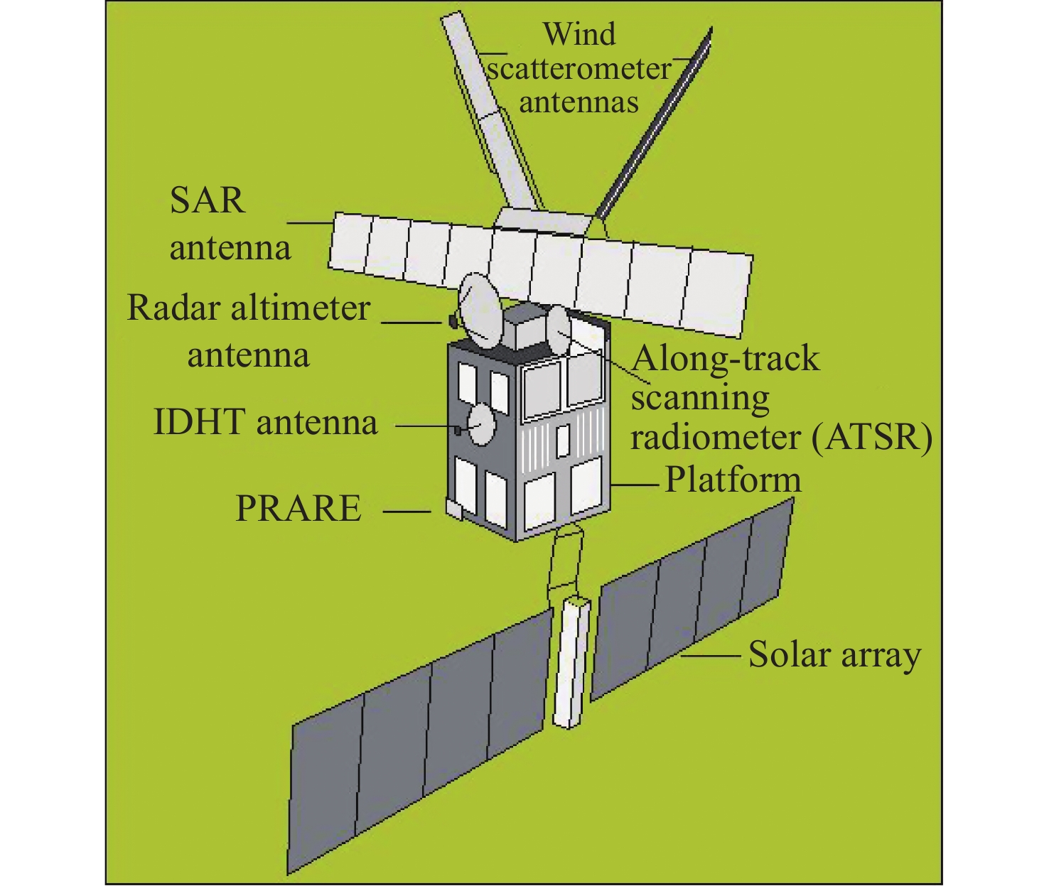
WINGHAM D J, FRANCIS C R, BAKER S, et al. CryoSat: A mission to determine the fluctuations in Earth’s land and marine ice fields[J]. Advances in Space Research, 2006, 37(4): 841-871 doi: 10.1016/j.asr.2005.07.027
|
| [37] |
BOY F, DESJONQUERES J D, PICOT N, et al. CryoSat-2 SAR-mode over oceans: processing methods, global assessment, and benefits[J]. IEEE Transactions on Geo science and Remote Sensing, 2017, 55(1): 148-158 doi: 10.1109/TGRS.2016.2601958
|
| [38] |
DONLON C J, BERRUTI B, BUONGIORNO A, et al. The global monitoring for environment and security (GMES) sentinel-3 mission[J]. Remote Sensing of Environment, 2012, 120: 37-57 doi: 10.1016/j.rse.2011.07.024
|
| [39] |
Donlon C J, CULLEN R, GIULICCHI L, et al. The Copernicus Sentinel-6 mission: Enhanced continuity of satellite sea level measurements from space[J]. Remote Sensing of Environment, 2021, 258: 112395 doi: 10.1016/j.rse.2021.112395
|
| [40] |
JIANG M F, XU K, WANG J M. Evaluation of Sentinel-6 altimetry data over ocean[J]. Remote Sensing, 2022, 15(1): 12 doi: 10.3390/rs15010012
|
| [41] |
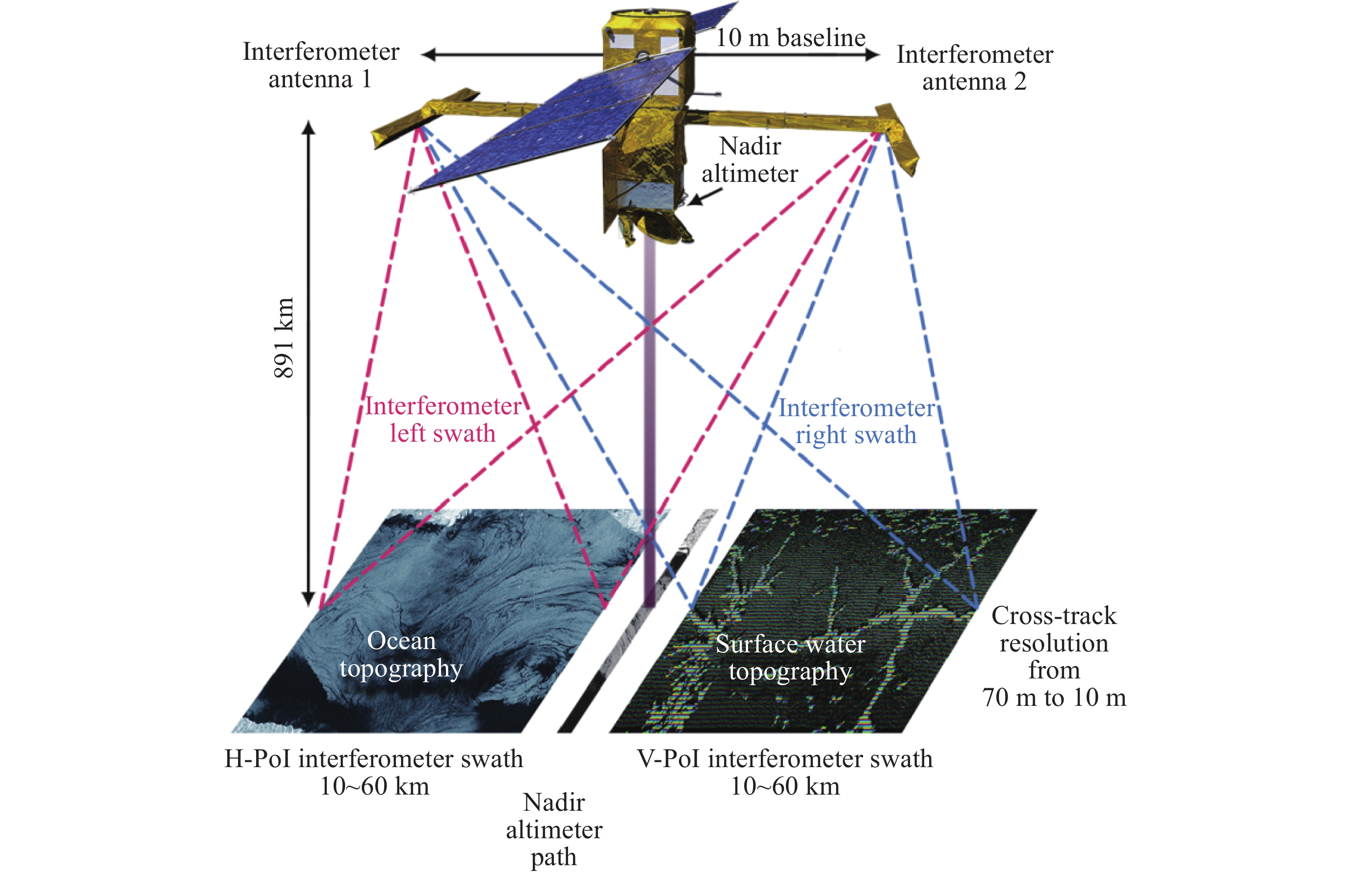
POLLARD B D, RODRIGUEZ E, VEILLEUX L, et al. The wide swath ocean altimeter: radar interferometry for global ocean mapping with centimetric accuracy [C]//IEEE Aerospace Conference. Big Sky, MT, USA: IEEE, 2002
|
| [42] |
FJORTOFT R, GAUDIN J M, POURTHIE N, et al. KaRIn on SWOT: Characteristics of Near-Nadir Ka-Band interferometric SAR imagery[J]. IEEE Transactions on Geoscience and Remote Sensing, 2014, 52(4): 2172-2185 doi: 10.1109/TGRS.2013.2258402
|
| [43] |
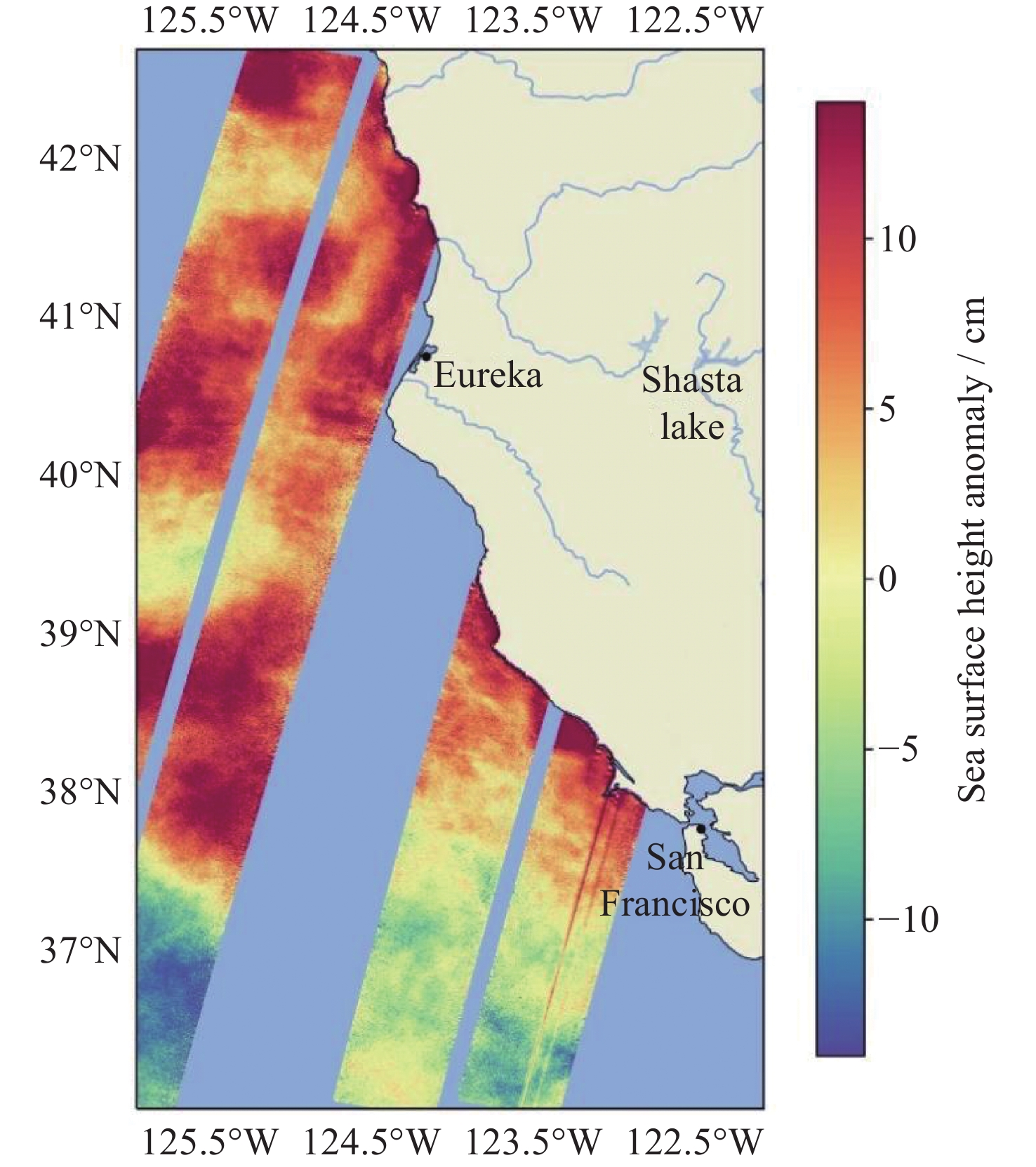
NASA/JPL. Water-watching satellite monitors warming ocean off California coast[EB/OL]. (2023-09-19)[2023-10-26]. https://swot.jpl.nasa.gov/news/107/water-watching-satellite-monitors-warming-ocean-off-california-coast/
|
| [44] |
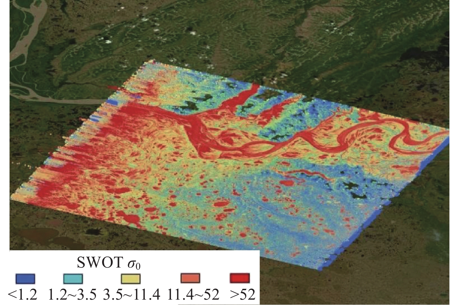
NASA/JPL. SWOT captures the Yukon River in Alaska[EB/OL]. (2023-09-11)[2023-10-26]. https://swot.jpl.nasa.gov/news/106/swot-captures-the-yukon-river-in-alaska/
|
| [45] |
XU K, JIANG J S, LIU H G, et al. HY-2A radar altimeter design and in flight preliminary results[C]//2013 IEEE International Geoscience and Remote Sensing Symposium. Melbourne: IEEE, 2013
|
| [46] |
QIN D, JIA Y J, LIN M S, et al. Performance evaluation of China’s first ocean dynamic environment satellite constellation[J]. Remote Sensing, 2023, 15(19): 4780 doi: 10.3390/rs15194780
|
| [47] |
YU F J, QI J J, JIA Y J, et al. Evaluation of HY-2 series satellites mapping capability on mesoscale eddies[J]. Remote Sensing, 2022, 14(17): 4262 doi: 10.3390/rs14174262
|
| [48] |
ZHANG S J, ZHOU R S, JIA Y J, et al. Performance of HaiYang-2 altimetric data in marine gravity research and a new global marine gravity model NSOAS22[J]. Remote Sensing, 2022, 14 (17)
|
| [49] |
WAN X Y, WANG H B, JIA Y J, et al. Performance of Haiyang-2 derived gravity field products in bathymetry inversion[J]. Remote Sensing, 2022, 15(1): 32 doi: 10.3390/rs15010032
|
| [50] |
ZHONG W Q, JIANG M F, XU K, et al. Arctic sea ice lead detection from Chinese HY-2B radar altimeter data[J]. Remote Sensing, 2023, 15(2): 516 doi: 10.3390/rs15020516
|
| [51] |
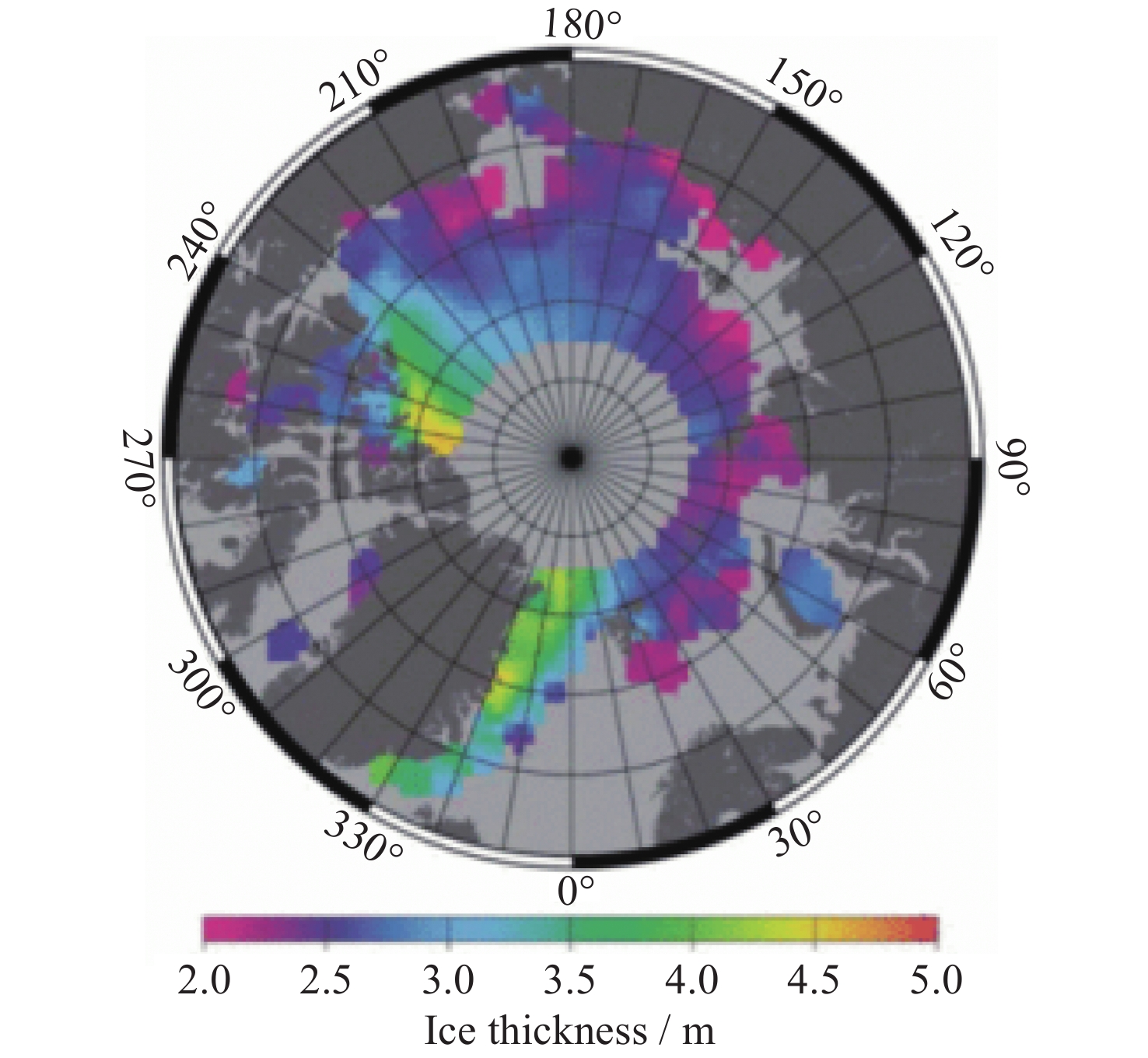
JIANG M F, ZHONG W Q, XU K, et al. Estimation of Arctic Sea Ice thickness from Chinese HY-2B radar altimetry data[J]. Remote Sensing, 2023, 15(5): 1180 doi: 10.3390/rs15051180
|
| [52] |
DONG Z Q, SHI L J, LIN M S, et al. Feasibility of retrieving Arctic sea ice thickness from the Chinese HY-2B Ku-band radar altimeter[J]. The Cryosphere, 2023, 17(3): 1389-1410 doi: 10.5194/tc-17-1389-2023
|
| [53] |
PHILIP A, TABURET G, CHARLES E, et al. HY-2B now used operationally in multi-mission sea level and wave systems [EB/OL]. (2020-10-19)[2023-10-26]. https://ostst.aviso.altimetry.fr/fileadmin/user_upload/tx_ausyclsseminar/files/OSTST_2020_HY2B_feedbacks_and_contribution.pdf
|
| [54] |
LABROUE S, RAYNAL M, PIRIZ F, et al. Performance of the altimetry constellation: contribution of HY2B mission [EB/OL]. (2019-10-23)[2023-10-26]. https://ostst.aviso.altimetry.fr/programs/abstracts-details.html?tx_ausyclsseminar_pi2%5BobjAbstracte%5D=2772&cHash=524847cb8397fe1cedc24474fdd8e741
|
| [55] |
AOUF L, WANG J, DALPHINET A. On the assessement of the assimilation of HY2B Significant wave height in the wave model MFWAM (2020-10-19)[2023-10-26]. https://ostst.aviso.altimetry.fr/fileadmin/user_upload/tx_ausyclsseminar/files/OSTST2020_LAouf_HY2B.pdf
|
| [56] |
王磊, 许可, 史灵卫, 等. 一种消除合成孔径雷达高度计延迟校正中残余误差的新算法及仿真验证[J]. 电子与信息学报, 2015, 37(11): 2713-2718 doi: 10.11999/JEIT150282
WANG Lei, XU Ke, SHI Lingwei, et al. A new range migration correction algorithm and its simulation for SAR altimeter[J]. Journal of Electronics & Information Technology, 2015, 37(11): 2713-2718 doi: 10.11999/JEIT150282
|
| [57] |
SHI L, XU K, LIU P, et al. Height precision of SAR altimeter and conventional radar altimeter based on flight experimental data[J]. IEEE Journal of Selected Topics in Applied Earth Observations and Remote Sensing, 2016, 9(6): 2676-2686 doi: 10.1109/JSTARS.2016.2550030
|
| [58] |
王佳明, 许可, 蒋茂飞. 基于加权最小二乘的合成孔径高度计重跟踪估计器设计与验证[J]. 电子与信息学报, 2022, 44(6): 2135-2142 doi: 10.11999/JEIT210354
WANG Jiaming, XU Ke, JIANG Maofei. Design and verification of retracking estimator for synthetic aperture altimeter based on weighted least squares[J]. Journal of Electronics & Information Technology, 2022, 44(6): 2135-2142 doi: 10.11999/JEIT210354
|
| [59] |
王佳明, 许可, 蒋茂飞. 一种用于合成孔径高度计的开环抗混叠滤波方法[J]. 遥感技术与应用, 2023, 38(3): 680-687
WANG Jiaming, XU Ke, JIANG Maofei. An open burst anti-aliasing filtering method for Synthetic Aperture Radar Altimeter[J]. Remote Sensing Technology and Application, 2023, 38(3): 680-687
|
| [60] |
张云华, 姜景山, 张祥坤, 等. 三维成像雷达高度计机载原理样机及机载试验[J]. 电子学报, 2004, 32(6): 899-902 doi: 10.3321/j.issn:0372-2112.2004.06.005
ZHANG Yunhua, JIANG Jingshan, ZHANG Xiangkun, et al. Principle model and preliminary flight experiment of the three-dimensional imaging radar altimeter[J]. Acta Electronica Sinica, 2004, 32(6): 899-902 doi: 10.3321/j.issn:0372-2112.2004.06.005
|
| [61] |
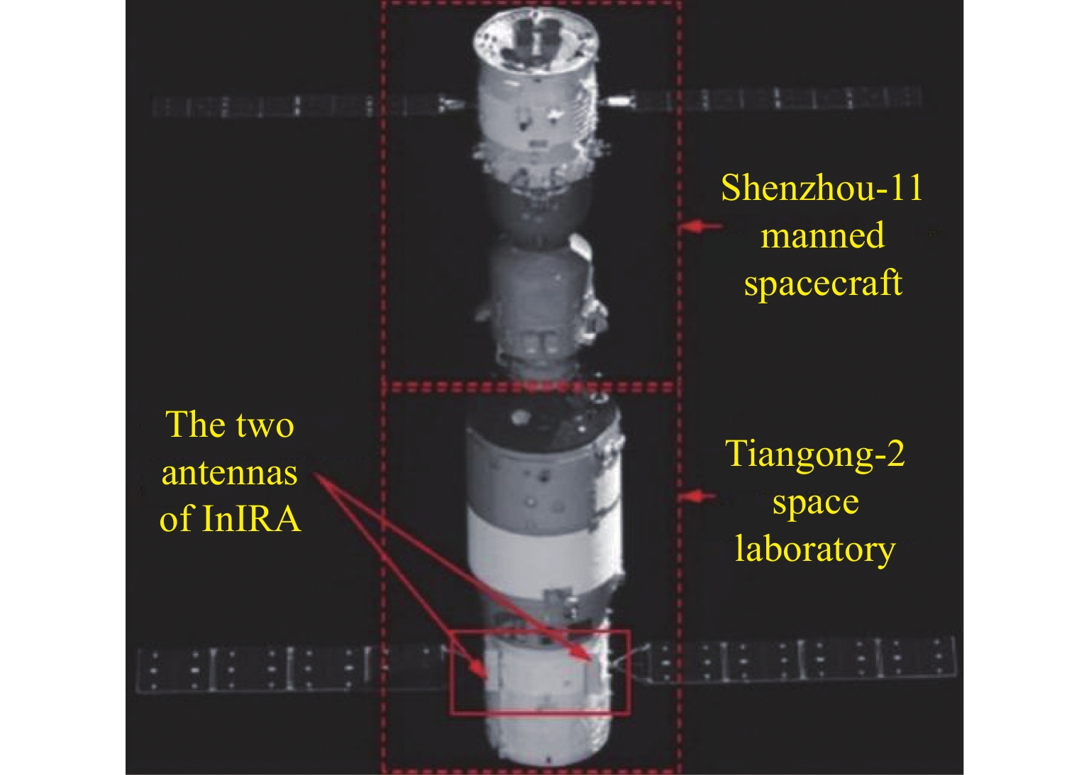
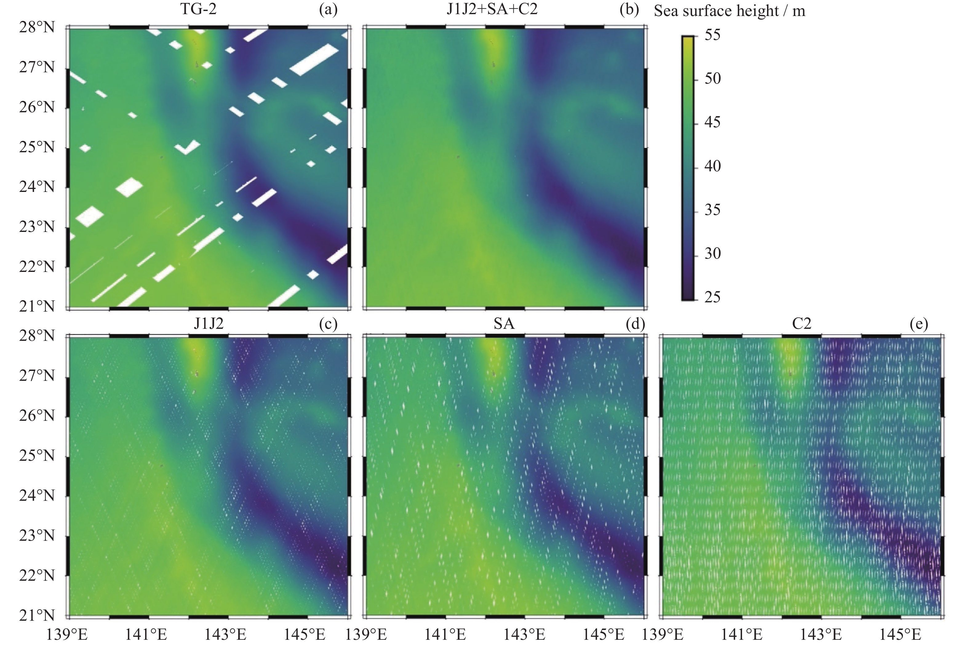
REN L, YANG J S, DONG X, et al. Preliminary evaluation and correction of sea surface height from Chinese Tiangong-2 Interferometric imaging radar altimeter[J]. Remote Sensing, 2020, 12(15): 2496 doi: 10.3390/rs12152496
|
| [62] |
SUN M, ZHANG Y, DONG X, et al. Preliminary results of marine gravity recovery by Tiangong-2 interferometric imaging radar altimeter[J]. Remote Sensing, 2023, 15: 4759 doi: 10.3390/rs15194759
|
Figures(33) / Tables(10)
Journal Introduction
ISSN 2097-7689 CN 11-1783/V
Copyright © Editorial Office of Chinese Journal of Space Science. 京ICP备08100722号
Supported by: Beijing Renhe Information Technology Co., Ltd.


 DownLoad: