2025 Vol. 45, No. 1

Survey and Strategy
Strategic Analysis of Scientific Activities and Study on the Overall Plan of Scientific Operation Platforms Based on the Lunar Research Station
PEI Zhaoyu, WANG Qiong, XU Lin, ZHANG Chenxuan, ZHANG Feng, ZHANG Xianguo, WANG Huijuan, JIA Yingzhuo, LIU Yang, XUE Changbin, ZHANG Jinhai, ZHANG Tianxin, PENG Jing, WANG Chi, ZOU Yongliao
2025, 45(1): 1-14. doi: 10.11728/cjss2025.01.2024-0188
Abstract:
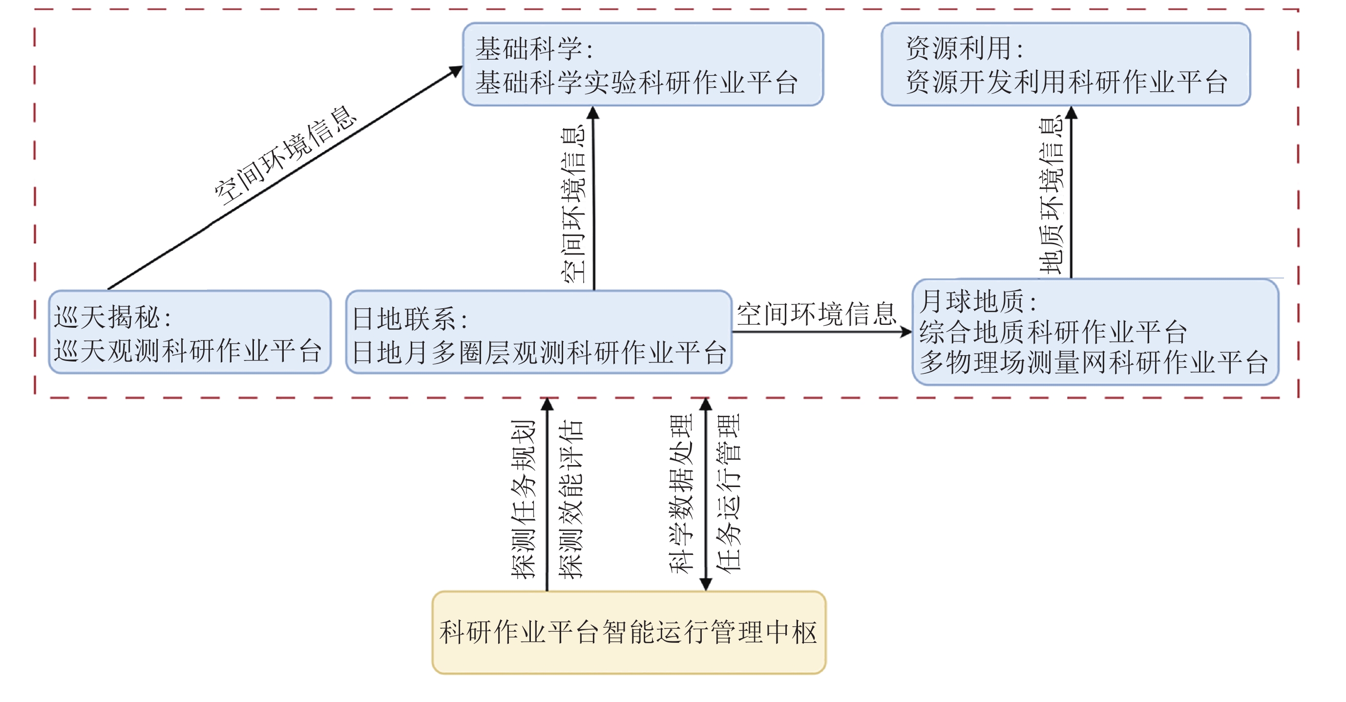
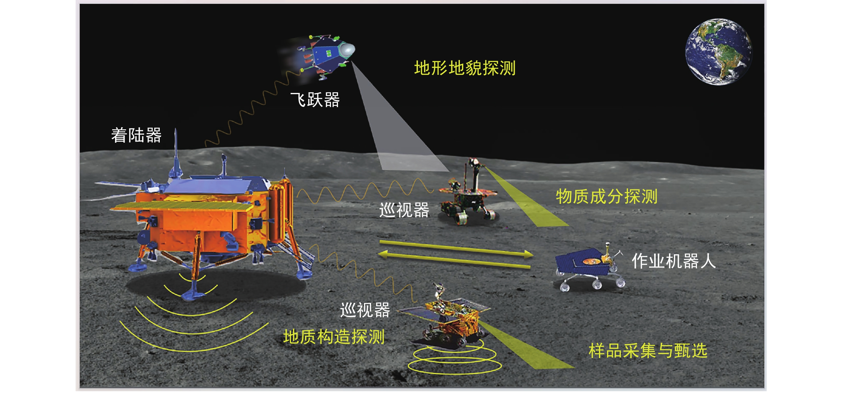
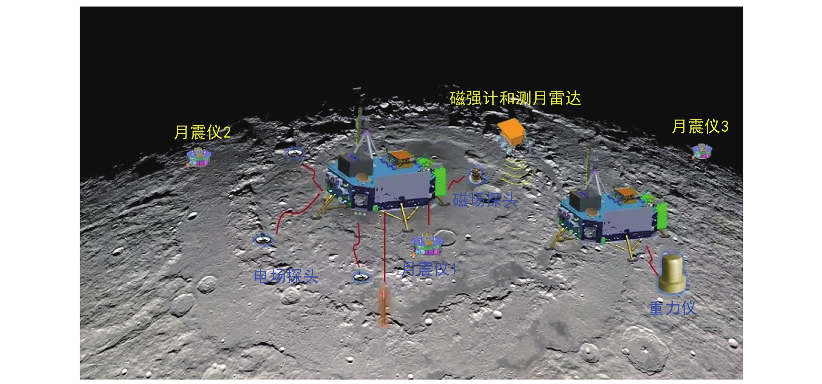
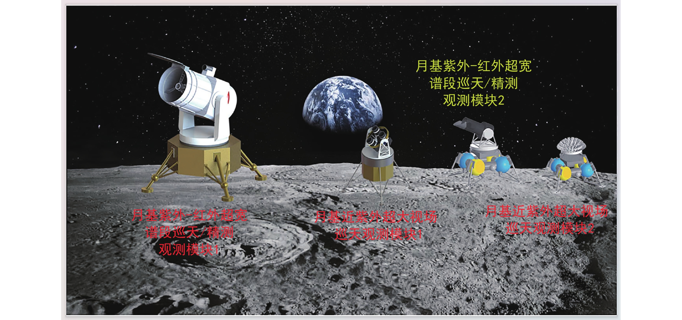
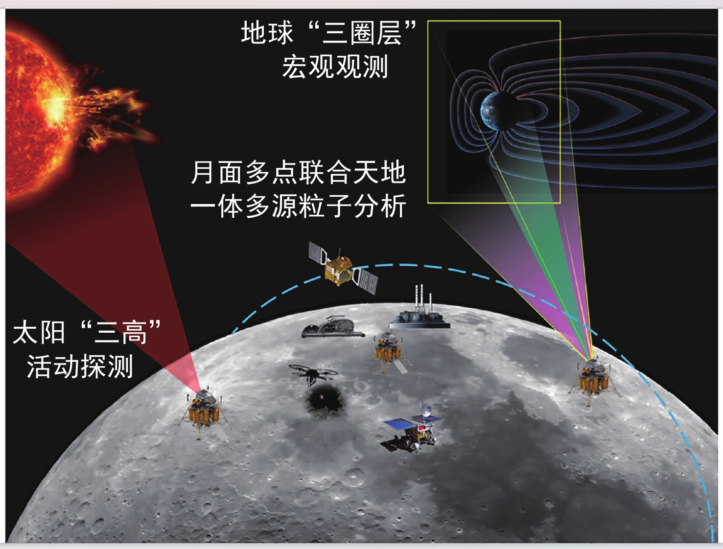
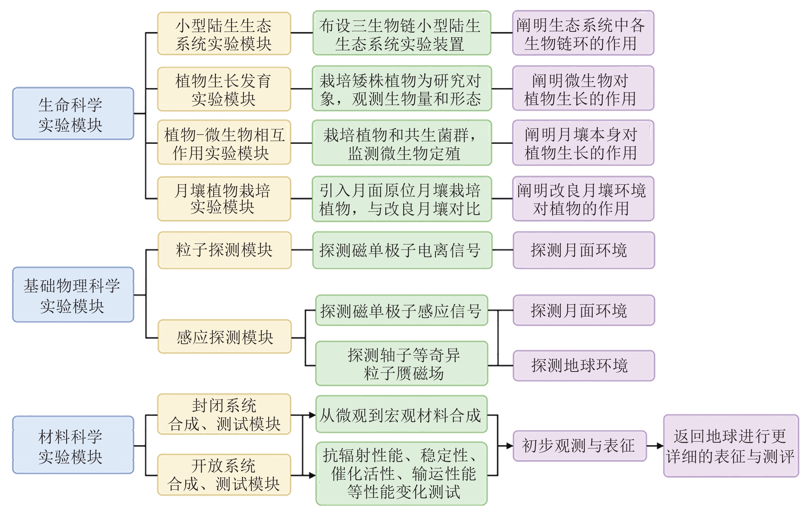
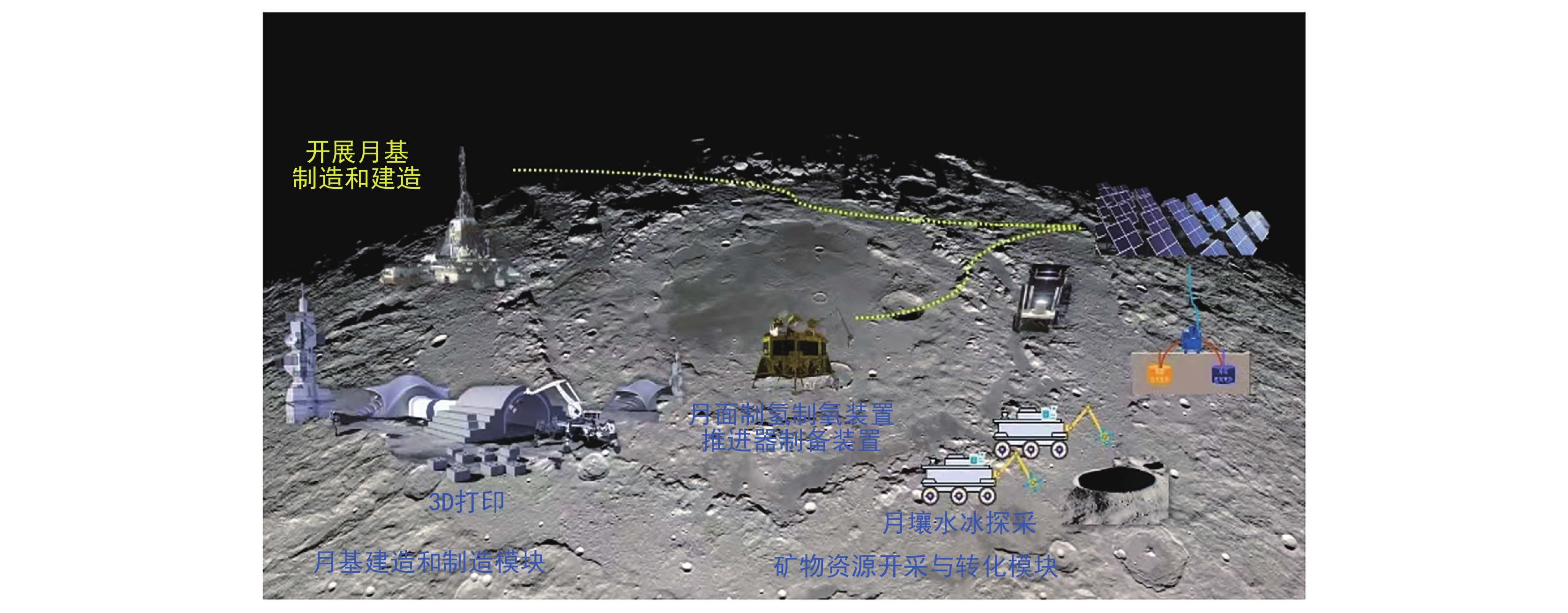
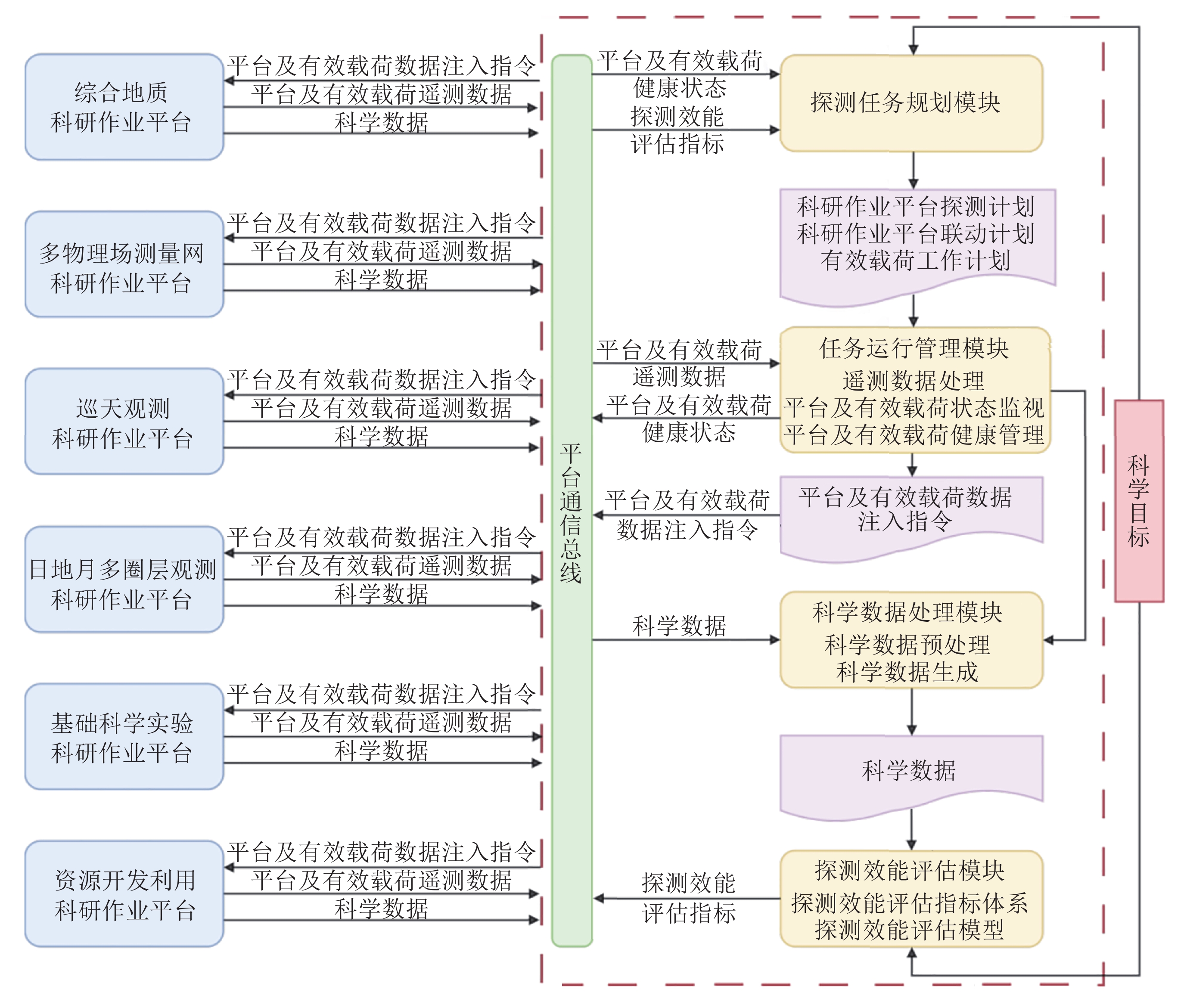
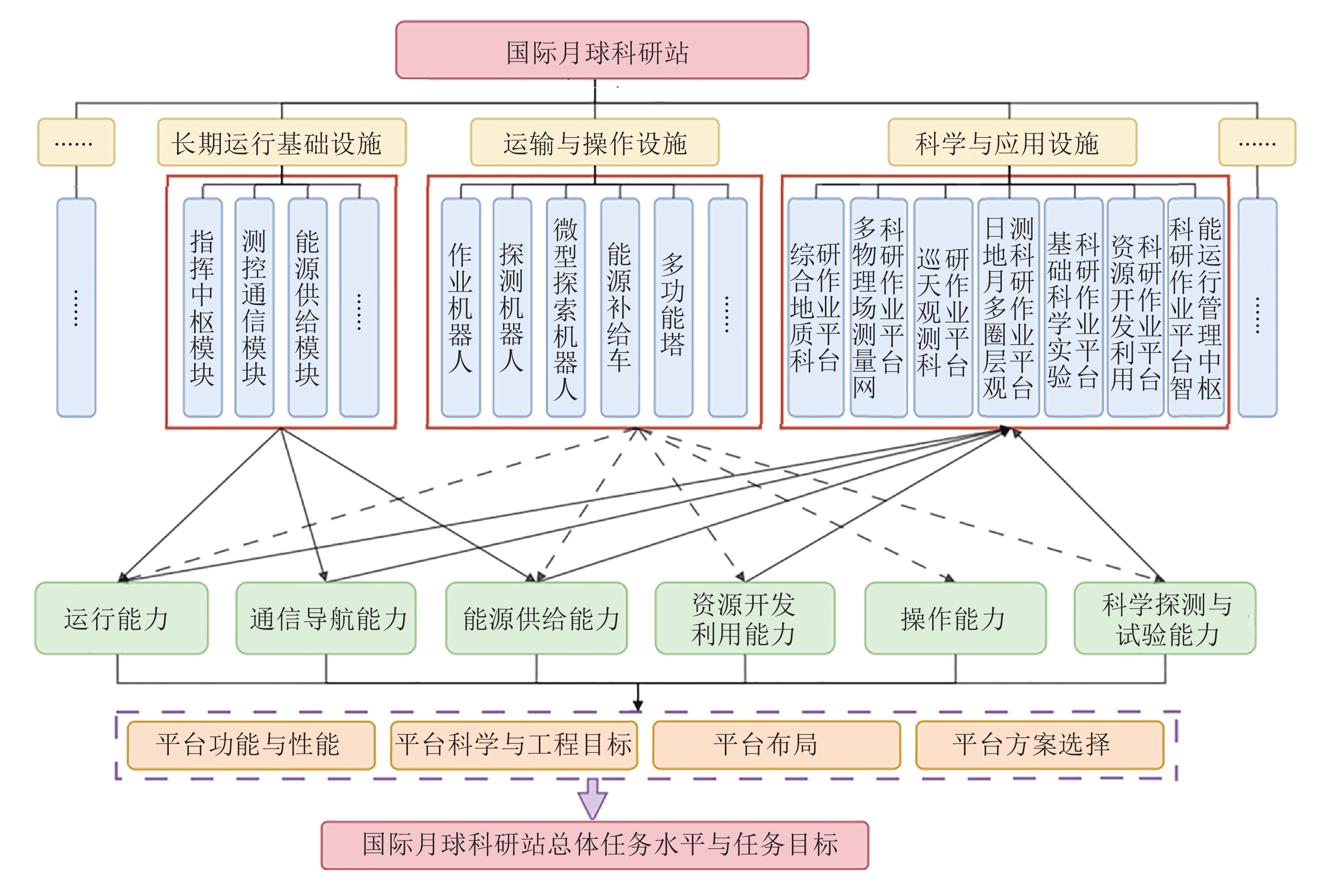
The Moon, the Earth’s only natural satellite, has always been the main target of international deep space exploration and an ideal test ground to promote the development of advancing aerospace technologies because of its unique space position, space environment, and material resources. The establishment of the lunar research station will be a primary objective of future lunar exploration, providing an unique observational opportunity for multidisciplinary frontier scientific research. These include studies of lunar geological evolution, the early history of the universe, celestial body formation across scales, coupling mechanisms of the Sun-Earth-Moon system, physical and biological effects, as well as unique properties of materials. This development marks a paradigm shift from single-mission exploration to integrated multi-mission frameworks, driving scientific activities towards intelligent, multi-task, and multi-objective systems. This paper reviews the development trends in lunar exploration and analyzes the scientific objectives and application requirements for the International Lunar Research Station (ILRS) proposed by China. It outlines a conceptual framework for scientific operation platforms designed for lunar research, presenting an architecture composed of six specialized platforms: comprehensive geological research, multi-physical field measurement networks, astronomical survey systems, Sun-Earth-Moon coupling observation networks, fundamental science experiment modules, and lunar resource utilization platforms. These platforms are tailored to address diverse research requirements, ranging from detailed lunar surface surveys and geophysical measurements to large-scale astrophysical observations and advanced biophysical and material science experiments. To ensure effective operation, an intelligent management hub is proposed, serving as the command center for data processing, operational coordination, and real-time task optimization. This hub supports autonomous mission planning, integrated data analysis, and dynamic resource allocation, ensuring efficient collaboration between different platforms. By integrating these systems, the ILRS aims to provide a foundation for sustainable, long-term lunar exploration and multidisciplinary scientific breakthroughs. This study highlights the strategic significance of establishing the ILRS, which seeks to foster global collaboration, drive innovations in deep space exploration, and serve as an open, inclusive, and sustainable platform for addressing major scientific and technological challenges. The conceptual framework proposed herein aligns with the vision of advancing humanity’s understanding of the Moon and beyond, supporting the long-term development of lunar science and exploration.
Analysis and Implications of NASA’s Moon to Mars Strategic Architecture
XIA Yifeng, GAO Yuyue, ZHOU Cheng
2025, 45(1): 15-28. doi: 10.11728/cjss2025.01.2024-0003
Abstract:
Lunar and Martian exploration ventures embody a magnitude of grand scale, elongated operational timelines, elevated execution complexities, and the engagement of multifaceted mission phases alongside a diverse array of objectives. These inherent characteristics underscore the imperative need for a comprehensive strategic roadmap to navigate these ambitious undertakings. In response, an alliance of institutions under the auspices of the National Aeronautics and Space Administration (NASA) has published the Moon to Mars Architecture Definition Document, thereby furnishing a guiding compass for both lunar and Martian exploration missions. This study commences with an overview of NASA’s meticulously crafted M2M architecture, delving into the intricacies of its strategic goal hierarchy. It proceeds to meticulously untangle the system implementation phases, accompanied by a critical examination of the archetype missions embedded within these phases. The investigation also encompasses a thorough discourse on the criteria utilized for the appraisal of this strategic infrastructure, elucidating the metrics and principles that underpin its evaluation. Through meticulous dissection of the M2M Architecture Definition Document, this research illuminates the nuanced definitions and classifications of strategic objectives, unraveling the systemic functionality requisites across various mission execution stages. Moreover, it conducts a rigorous gap analysis, pinpointing disparities against the backdrop of the strategic architecture’s evaluative benchmarks. Culminating from this exhaustive analysis, the paper advances a forward-thinking perspective, distilled from a meticulous parsing of the “Moon to Mars Architecture”. This perspective aims to illuminate prospective avenues, offering a strategic compass for strategic trajectory planning of our nation’s impending space exploration endeavors, and formulating a holistic blueprint for lunar and Martian exploration programs. It aspires to contribute a set of insightful and actionable recommendations, thereby enriching the strategic discourse and enhancing the practical utility of future mission planning in the realm of celestial exploration.
Review
Research on Ultracold Atom Physics in Microgravity
LI Lin, WANG Bin, ZHOU Xiaoji, CHEN Xuzong, LI Tang, LIU Liang
2025, 45(1): 29-55. doi: 10.11728/cjss2025.01.2024-0174
Abstract:
The China Space Station (CSS) provides an ideal experimental platform for researching and applying ultracold atoms in microgravity. On 31 October 2022, the Cold Atom Physics Research Rack (CAPR) was launched to the CSS together with the Mengtian lab module, designed by the Shanghai Institute of Optics and Fine Mechanics of the Chinese Academy of Sciences (SIOM) and Peking University. The main goal of the CAPR is to build an ultracold atomic physics experiment platform using 87Rb Bose Einstein Condensate (BEC) in the CSS. In microgravity, ultracold atoms can be cooled to picokelvin (pK) via Two-Stage Crossed Beams Cooling (TSCBC), which is three orders of magnitude lower than on earth and can inspire the novel physical phenomena. The preparation of the BEC and the deep cooling are introduced in this paper, as well as a series of advancements in ultracold atoms in microgravity. The CAPR is an experimental platform that relies on evaporative cooling in a crossed optical dipole trap. Furthermore, the CAPR’s design scheme and ground verification experiment are also introduced. So far, the CAPR has continued to conduct research on ultracold atoms in microgravity, with more than two years of uninterrupted operation in orbit. Up to now, preliminary experimental results have been achieved, realizing the primary purpose of the CAPR.
Space Physics
Simulation on the Mechanism of Harmonic Maser Emission Through the Wave Coalescence Process
LIU Gonglin, NING Hao, NI Sulan, LI Chuanyang, ZHANG Zilong, LI Yaokun, CHEN Yao
2025, 45(1): 56-65. doi: 10.11728/cjss2025.01.2024-yg29
Abstract:
Electron Cyclotron Maser Emission (ECME) driven by electrons with loss-cone distribution is the main mechanism for explaining solar radio spikes. However, in strongly magnetized plasmas, the losscone-driven ECME mainly generates fundamental X mode emissions, which can be efficiently absorbed when escaping through the second-harmonic layer in the solar corona. To solve the “escaping difficulty”, recent studies suggested a new mechanism of harmonic maser emission (X2) involving nonlinear wave coupling process of Z-mode and fundamental X-mode (X1) waves (Z+Z→X2, Z+X1→X2). It is necessary to verify the nonlinear wave coalescence process with theoretical analyses and numerical simulations. Here, the possibility of a nonlinear wave coupling process is examined via solving the matching conditions for three-wave resonant interaction based on the dispersion relation of cold plasma in magneto-ionic theory.The matching conditions for the Z and/or X1 waves were found to be satisfied over a wide range of parameters, leading to the production of X2 emissions that propagate perpendicularly and obliquely relative to the direction of the background magnetic field. Based on the solutions obtained in the matching condition analysis, we selected four sets of solutions of Z+Z and Z+X1 to perform particle-in-cell simulations using wave pumping method, to verify the nonlinear process of wave coalescence generating second harmonic X-mode emissions. With X1 and/or Z modes correctly pumped in the simulation domain, efficient generation of X2 emissions was observed, with saturation achieved within 400 $ {\varOmega }_{\mathrm{c}\mathrm{e}}^{-1} $. The conversion rate of energies of X2 emissions to Z mode waves varies from 2% to 8%. The study presents strong evidence to support the new mechanism of harmonic maser emission, which can be widely applied to explain the solar and space radio emissions.
Identification Model of Pi2 Pulsation Based on One-dimensional Residual Convolutional Neural Network
ZHANG Yiyue, ZOU Ziming, FANG Shaofeng
2025, 45(1): 66-81. doi: 10.11728/cjss2025.01.2024-0018
Abstract:
Pi2 pulsations are irregular ultra-low frequency waves, representing a significant transient response to the coupling between the magnetosphere and ionosphere. Their occurrence is associated with onset of substorms. As a disturbance phenomenon in the Earth’s magnetosphere, the occurrence signal of Pi2 pulsations is hidden within the observation data of geomagnetic field components. Addressing the increasing amount of observation data, how to efficiently determine whether Pi2 pulsation has occurred in a segment of geomagnetic field component observational data is the key to build a Pi2 pulsation identification model. Based on the time series observation data of the FGM from the Chinese Meridian Project and One-Dimensional Residual Convolutional Neural Network (1D-ResCNN), this paper establishes an end-to-end Pi2 pulsation identification model. This model can distinguish whether Pi2 pulsation occurs in the observation data of a certain geomagnetic field component. Experimental results show that this model has higher recognition accuracy and lower false positive rate and false negative rate than the existing Pi2 pulsation machine learning identification model.
Machine Learning Solar Full Disk Flare Operational Forecasting
LI Ming, CUI Yanmei, LUO Bingxian
2025, 45(1): 82-90. doi: 10.11728/cjss2025.01.2024-0021
Abstract:
Solar flare forecasting is an essential component in space environment forecasting. Most of the deep learning flare forecasting models constructed are based on the magnetograms of active regions. Affected by the projection effect, these models can only forecast the active region in the center of the Sun. It is difficult to meet the need of operational flare forecasting of the solar full disk. Based on the traditional solar activity parameters, in this study, the relationships between the magnetic type of the active region, area of the active region, the history of the flare outburst, the 10 cm radio flux and flares from January 1996 to December 2022 were statistically analyzed. By using the fully connected neural network, an operational flare forecasting model for solar full disk active regions was constructed. This model can forecast the eruption of the M-class or above flares of the full solar disk active regions in the next 48 h. The F1 score of the model is 0.4304, the TSS is 0.3689, and the HSS is 0.3906. The model is compared with the deep learning flare forecasting model constructed in the previous work, and the results show that the operational forecasting model constructed in this paper has a better forecasting performance. Meanwhile, in order to explore the influence of the projection effect, the solar full disk active regions flare forecasting model constructed was tested for test data within 30 degrees from the center of the solar disk, within the interval from 30 degrees to 60 degrees, and over 60 degrees, respectively. The results show that the projection effect has little influence on the flare forecast model constructed in this study. The model can be used to forecast flare in the active region of the full solar disk, and provide an effective tool for operational solar flare forecasting.
Using Deep Learning to Achieve Short Term Business Forecast of Dst Index
NIU Ben, HUANG Zhi
2025, 45(1): 91-101. doi: 10.11728/cjss2025.01.2024-0034
Abstract:
Magnetic storm events triggered by solar activity can cause dramatic changes in the Earth’s magnetic field, significantly impacting the performance of systems such as communications, navigation, and power supply. These disturbances can interfere with radio signal propagation, reduce navigation accuracy, and disrupt power transmission networks. Therefore, accurately predicting magnetic storms is crucial for mitigating their effects. In space physics, the Dst index is commonly used to characterize the intensity of magnetic storms. It serves as a vital global indicator of geomagnetic activity. To enhance the prediction of magnetic storms and reduce their adverse effects, an efficient and accurate predictive model is essential. This paper proposes a magnetic storm prediction model based on Convolutional Neural Networks (CNN), Gated Recurrent Units (GRU), and Long Short-Term Memory networks (LSTM), referred to as the C-G-LSTM model. This hybrid model leverages the strengths of CNN, GRU, and LSTM to predict the Dst index 1 to 6 h in advance, providing valuable lead time for responding to potential magnetic storm events. CNNs effectively extract spatial features from input data, while GRUs and LSTMs excel at handling time series data and capturing temporal dependencies. The performance of the C-G-LSTM model was evaluated using Dst index data provided by NASA, covering the period from 2010 to 2019. The results demonstrate that this model performs exceptionally well in predicting the Dst index. Specifically, the maximum Root Mean Square Error (RMSE) does not exceed 7.29 nT, and the Maximum Mean Absolute Error (MAE) does not exceed 5.03 nT. Although errors increase during intense magnetic activity, the model maintains high accuracy. A significant advantage of the C-G-LSTM model is that it does not require additional input parameters such as solar wind temperature, solar wind dynamic pressure, and interplanetary magnetic field components, which are often needed in other models. This makes the C-G-LSTM model more straightforward and practical for operational forecasting. Its high accuracy and efficiency in predicting magnetic storms can provide timely warnings, helping to mitigate potential impacts on communication, navigation, and power systems. In conclusion, the C-G-LSTM model represents a significant advancement in predicting magnetic storm events, offering a reliable and accurate method for forecasting the Dst index and enhancing our ability to manage the effects of solar activity on critical engineering systems.
Seasonal Variation Characteristics of Sodium Layer in Low Latitude by Lidar
HE Shimin, ZHANG Tiemin, CHAI Weiwei, ZHANG Yimin, YANG Dali, PENG Hongyan, WANG Jihong
2025, 45(1): 102-112. doi: 10.11728/cjss2025.01.2024-0035
Abstract:
Sodium lidar observations of sodium layer from 2018 to 2019 at a low-latitude location (Haikou, China, 20°N, 110.3°E) are reported in this paper. The purpose is to reveal characteristics of seasonal variations of the sodium layer, including density distribution characteristics, seasonal variation characteristics and special events of sodium layer. According to statistical analysis, there is a great correlation between the variation of sodium layer and seasons. Average density of sodium layer presents a basically symmetrical Gaussian distribution, with good morphological symmetry in autumn. Column density and peak value are small in spring and summer and vice versa in autumn and winter. Peak position is high in summer and low in autumn. There is no clear seasonal variation about the centroid height of the sodium layer. Full Width at Half Maximum (FWHM) and Root Mean Square (RMS) width of sodium layer are both small in autumn and large in winter. Sporadic Sodium Layers (SSLs) change obviously with seasons and the growth, decline and duration time are short in summer and long in spring. Peak value has the minimum in spring and maximum in autumn, respectively. Peak position tends to be higher during autumn and winter but lower during spring and summer. The intensity is the largest in summer. Except autumn, peak value of other seasons is mostly in the latter half of the night. With respect to the correlation with sporadic E, combining with the ionosphere data obtained by the nearest ionosonde at Danzhou, China ($ 19.5°\mathrm{N}, 109.1°\mathrm{E} $), there is a considerable correlation between sporadic E layers (Es) and SSLs above 97 km at low latitude, which is embodied in the time, height and intensity. By statistical analysis of special events, it is found that the probability of SSLs in winter is high and the Double Sodium Layer (DSL) mostly appears in spring and summer at Haikou.
Seasonal Transition Study of Thermospheric Atmospheric Composition Ratios at Twilight Based on Fengyun-3E Satellite Detection
SHI Zheng, FU Liping, JIANG Fang, MAO Tian
2025, 45(1): 113-124. doi: 10.11728/cjss2025.01.2024-0023
Abstract:
Two Fengyun-3 satellites are equipped with Ionospheric Photometers capable of detecting the integrated radiant flux of the OI 135.6 nm and N2 LBH band airglow emissions, from which the ratio (referred to as the 135.6/LBH ratio) is derived. Among them, the Fengyun-3E satellite, the second generation of near-polar sun-synchronous orbit satellites, provides airglow observations during dawn-dusk orbits. The 135.6/LBH ratio is typically proportional to the thermospheric atmospheric composition ratio of [O]/[N2], reflecting variations in this ratio, which is a significant parameter influencing changes in ionospheric electron density. This paper collects data from Fengyun-3E satellite in the past two years to analyze the seasonal conversion patterns of 135.6/LBH ratio and corresponding parameters in mid to low latitudes. The results showed that the seasonal variation of OI 135.6 nm and N2 LBH band radiation intensity was mainly in winter and summer, with rapid changes in spring and autumn, and this change varies with latitude. The 135.6/LBH ratio also shows a rapid transition in spring and autumn, but its peak and valley periods are different from the aforementioned two radiation intensities. The mid latitude region shows a seasonal characteristic of high in winter and low in summer, while the opposite is true near the equator, showing a semiannual variation cycle. The study also found that there is asymmetry in the seasonal transition of the 135.6/LBH ratio, which is significantly influenced by latitude and hemisphere. These results demonstrate that the Fengyun satellite ionospheric photometer has good performance in detecting seasonal, latitudinal, and hemispheric variations in the composition ratio of the thermosphere atmosphere, providing important basis for research, modeling, and space weather forecasting of the ionospheric thermosphere.
Inversion of Atmospheric Temperature Based on THz Radiometer
ZHU Jiawei, ZHOU Chen, ZHAO Zhengyu, LIU Yi
2025, 45(1): 125-134. doi: 10.11728/cjss2025.01.2024-0069
Abstract:
Based on the airborne terahertz detector ATMI (Airborne THz Measure Instrument) developed by Wuhan University, this paper analyzes the inversion ability of ATMI for atmospheric temperature profiles in ground-based and air-based detection modes. In view of the hardware parameters of the ATMI prototype, under air-based and ground-based measurement modes, atmospheric radiation transfer models at different latitudes are established. The inversion ability of ATMI using the BP neural network algorithm for atmospheric temperature profiles at different latitudes is discussed. After the prototype leaves the factory, one-month ground-based field measurements are carried out in mid-latitude regions. The field measurement data are used to verify the inversion ability of the ATMI prototype for atmospheric temperature profiles. The field measurement results show that for the developed ATMI prototype, in the ground-based inversion, the accuracy is better than 1 K in the altitude range of 0~36 km, and within a certain altitude range, the highest accuracy can be better than 0.3 K. This proves the effectiveness and accuracy of the developed airborne terahertz detector for the inversion of atmospheric temperature profiles. Its stability and accuracy have reached the design specifications, indicating its wide application potential in terahertz science and near-space environment monitoring.
Research and Experimental Verification of Atmospheric Polarization State in the Near-infrared Band
CHEN Zhixing, GOU Wanxiang, TONG Shuai, ZHANG Mengyao, LI Chonghui
2025, 45(1): 135-148. doi: 10.11728/cjss2025.01.2024-0063
Abstract:
The study of atmospheric polarization is the prerequisite and foundation for polarization detection, polarization remote sensing, polarization imaging and other applications. Compared with the visible wavelength, the research on atmospheric polarization state in the near-infrared wavelength is relatively lagging behind. The existing literature is dominated by theoretical analysis and lacks experimental verification. In this paper, a short-wave infrared image sensor, an infrared lens, an infrared polarizer, an infrared filter, etc. are used to build a near-infrared atmospheric polarization measurement system, and the polarization state of the atmosphere in the near-infrared band of 900~1700 nm is measured in the whole sky under the sunny weather conditions. The results show that the atmosphere shows stable polarization patterns in the near-infrared band, in which the stability of the atmospheric polarization angle distribution is obviously better than that of the atmospheric polarization degree distribution; the atmospheric polarization patterns are in good agreement with the Rayleigh scattering characterization model, with 83% of the points in the whole sky area having a polarization angle error of less than 10°, and 79% of the points having a polarization degree error of less than 0.1, which makes it possible to predict the atmospheric polarization states in various directions effectively by relying on the Rayleigh scattering characterization model. In addition, the overall polarization of the atmosphere in the whole daytime area is not high, with an average value of 0.13, and only 0.1 at noon, which is different from the theoretical derivation and assumption of the previous literature, and the applicability of polarization filtering technology to the detection of daytime targets should be investigated in depth in the context of specific applications.
Microgravity and Space Life Science
Steam Condensing Characteristics in a Horizontal Circular Tube under Rotating Action
ZHANG Leigang, RU Meng, LI Hao, YUE Liwen, CHEN Zhenqian, MA Yanyang
2025, 45(1): 149-161. doi: 10.11728/cjss2025.01.2024-0004
Abstract:
Condensation is an important physical process in heat transfer equipment. Compared with the traditional single-phase flow loop, the latent heat released by the condensing phase change heat is quite large, so a very small amount of fluid flow can meet the thermal control requirements. With the continuous development of space industry, efficient thermal control technology becomes more and more important. Therefore, how to rationally use the two-phase transformation heat transfer technology must be seriously considered, and special attention must be paid to the influence of gravity on heat transfer. Traditional ground-based condensation techniques often rely on gravity to facilitate the discharge and flow of condensate, but in the weightless environment of space, these methods are no longer suitable. At present, methods such as free-fall tower drop and parabolic flight are mainly used to create microgravity environment. However, due to the short microgravity time obtained and the high cost of experiments, this study simulated different gravity conditions by centrifugal force method to study the influence of gravity, volume flow rate and tube diameter on the axial temperature change in horizontal tubes. Due to the influence of gravity conditions, the liquid will accumulate at the bottom, resulting in lower temperature of the tube wall. Through visual analysis, it can also be seen that there are wavy and spiral flow states in the tube. When gravity conditions change, the measured temperature is generally lower than that under normal gravity conditions. The deterioration of heat transfer depends on the operating conditions. The increase of steam flow rate will improve the deterioration of heat transfer, but the improvement is limited, and the overall temperature of the test section will be slightly increased. At low flow, test section temperature variations are more sensitive to gravitational conditions, while at high flow, test section temperature variations are insensitive to gravitational conditions. The above findings will help in the design and optimization of heat transfer equipment.
Effects of Radiation and Simulated Weightlessness on Rat EEG and Its Mechanism
FENG Jundong, TIAN Liuxin, LI Qian, ZHAO Xida, YANG Yingqing, WANG Weitai
2025, 45(1): 162-178. doi: 10.11728/cjss2025.01.2023-0149
Abstract:
This article aims to assess the impact of radiation and weightlessness on the brain, specifically through the analysis of bioelectrical signals. Our goal is to elucidate the patterns and mechanisms underlying the effects of radiation, weightlessness, and their combined influence on Electroencephalogram (EEG) signals. This understanding will serve as a crucial reference for risk assessment and protective technology research in space environments. A comprehensive study was conducted utilizing SD rats as the experimental subjects. The eight different experimental groups were established to analyze EEG signals and automatically detect abnormal brain signals caused by radiation or weightlessness exposure.To delve deeper into the underlying biological mechanisms, the expression levels of Myelin Basic Protein (MBP), Glial Fibrillary Acidic Protein (GFAP), and ionized calcium-binding adapter molecule 1 (IBA1) were examined in specific brain regions, such as the frontal lobe, temporal lobe, and hippocampus. The study found that rats exposed to radiation alone or in combination with weightlessness showed a marked slow-wave EEG pattern, with the combined effect being more significant, indicating an enhanced effect. The neural network model accurately distinguished normal from abnormal EEG signals. The decrease of MBP and increase of GFAP and IBA1 were observed in the combined radiation-weightlessness groups, suggesting myelin damage and activation of astrocytes and microglias. The study reveals the effects of radiation and weightlessness on brain signals, showing that radiation alone induces slow-wave EEG patterns, and the combination with weightlessness exacerbates these patterns. The mechanism involves myelin sheath damage and glial cell activation. This understanding is crucial for assessing risks and developing protective measures in space, laying the groundwork for future research to improve astronaut safety and well-being.
Space Exploration Technology
Analysis of the Influence and Importance of Laser Frequency Fluctuation on Laser Interference Simulation System for Space Gravitational Wave Detection
LIU Yu, ZHANG Yuzhu, PENG Xiaodong, ZHAO Mengyuan, YANG Zhen, TANG Wenlin, QIANG Li’e
2025, 45(1): 179-188. doi: 10.11728/cjss2025.01.2024-0020
Abstract:
The laser interferometric measurement system for space gravitational wave detection is of great significance for detection tasks, the noise of the interferometric measurement system is the key factor determining the success or failure of the task. Laser frequency noise is one of the most important noises. Therefore, it is necessary to analyze the impact and importance of laser frequency fluctuations on measurement results. Due to the difficulty in simulating the environment in space, analyzing based on simulation systems is an ideal approach. Based on the simulation system of space gravitational wave detection laser interferometry measurement, the measurement errors caused by laser frequency fluctuations of free running laser on the measurement results of scientific interferometer, reference interferometer, and TM interferometer models was analyzed. Then, sensitivity analysis was conducted using the derivative method and Sobol method with interference laser wavelength as input parameter. The influence and importance of laser frequency fluctuations of reference beam and measurement beam on the output of three interferometer models were analyzed. The results indicate that: laser frequency fluctuations during free running stages, which will cause changes in the measurement results of the interferometer, these changes are far greater than the picometers. Additionally, under the experimental conditions of this paper, the importance of measurement beam frequency fluctuation on the outputs of the three interferometers is 100%, 56%, and 54% respectively. The importance of reference beam frequency fluctuation on the outputs of the three interferometers is 0%, 44%, and 46% respectively.
Elastic Tube Model Predictive Control for Test Mass Capture for Space-borne Gravitational Wave Detection
HE Xiongfeng, LU Wei, XU Nuo, WANG Pengcheng, ZHANG Yonghe, CUI Bing, XIA Yuanqing
2025, 45(1): 189-200. doi: 10.11728/cjss2025.01.2024-0009
Abstract:
In the space-borne gravitational wave detection missions, test mass capture is critical for the spacecraft to enter the super-stable flight state. This process is characterized by large initial errors, large system uncertainties and strong execution constraints. This paper presents an improved high precision elastic tube model predictive control of test mass capture. A control structure based on rolling optimization and elastic tube technology is proposed to improve the capture success rate and effectively compensate the satellite coupling interference on test mass. The tiny tolerance active set method is proposed to improve the accuracy of online calculation and ensure the high control accuracy of test mass. Meanwhile, this paper proposes an offline correction method for the minimum robust positive invariant set based on feature engineering. It reduces the vertices of the minimum robust positive invariant set based on the Minkowski summation and reduces the online computational complexity. The proposed method is verified by simulations on the space-based double test masses full-freedom simulation platform. The results show that the control performance satisfies the test mass capture accuracy requirement. The controller is robust and the rate of convergence is improved effectively. The effects of platform motion interference and measurement noise are suppressed.
Geomagnetic/Inertial Fusion Navigation Method Based on Magnetic Anomaly Gradient Measurement
LIANG Yuxiao, GAO Dong
2025, 45(1): 201-214. doi: 10.11728/cjss2025.01.2024-0027
Abstract:
Geomagnetic navigation is an autonomous navigation method that utilizes the natural magnetic field of the Earth. It has various advantages such as strong autonomy and good anti-interference performance, and can work normally in various environments to play its role. However, in the fields of low altitude navigation and underwater navigation, geomagnetic matching navigation requires the construction of geomagnetic maps based on a large amount of measurement data, and requires the motion platform equipped with this navigation method to have high computing power. The above issues bring inconvenience to the application of geomagnetic navigation. Inertial navigation method is a commonly used autonomous navigation method that has high accuracy in a short period of time. However, over time, its navigation results will have significant cumulative errors, which will affect the accuracy of navigation positioning. This article extracts differential information of magnetic anomaly fields from the total measurement information of the Earth's magnetic field through differential measurement information at different positions during platform movement, as the observation of the paper. Meanwhile, based on the magnetic dipole characteristics of the magnetic anomaly field, this article derives a magnetic anomaly gradient measurement matrix that can be applied to navigation system filters on the basis of the magnetic dipole model theory. By using the magnetic anomaly gradient information to correct the cumulative error of the inertial navigation system, a geomagnetic/inertial fusion navigation method is proposed. This method can reduce the requirement for high-precision prior geomagnetic maps in geomagnetic navigation, while also correcting navigation errors in inertial navigation. Comparing the navigation method proposed in this article with the pure inertial navigation method, it was found that the navigation position accuracy of this method has significantly improved under the same conditions. The research conducted in this article explores a new method for autonomous navigation of motion platforms.
Weighted Divergence of Directionally Salient Features for Infrared Small Target Detection Enhancement
WANG Yiwen, ZHENG Wei, XING Chenglong
2025, 45(1): 215-225. doi: 10.11728/cjss2025.01.2024-0025
Abstract:
Infrared small target detection is widely used in fields such as dark and weak object detection, which is an important means of early warning for space environment safety. Drawing on entropy theory and incorporating the directionality of target diffusion, this study introduces a method for Infrared Small Target Detection Enhancement named Weighted Divergence of Directionally Salient Features (DSWD). Initially, this method assesses the local saliency of an image using a multi-layer nested window approach, and applies multidirectional spatial filtering to highlight point targets that radiate outward from the center to eight directions within the infrared spectrum, thereby enhancing the target against a complex backdrop. To address the disparity between the anisotropic distribution of saliency features and the homogeneous background distribution, this study employs a scatter measure to quantify the probabilistic distribution between the target area and the background, thus identifying regions of interest. Nevertheless, the efficacy of target extraction can be compromised by obfuscating elements, such as prominently illuminated backgrounds. To mitigate this, the study leverages an enhanced absolute mean square deviation technique for further target refinement, ensuring precise separation and extraction from the intricate background. The process culminates with the application of an adaptive threshold segmentation method for final target extraction. The experimental results show that for the variable space environment, the method proposed in this paper can accurately detect the weak targets in the space environment and reduce the false alarm rate, which is expected to be applied in the future space environment safety warning system or for reference.
Comparison and Application of Simplified Calculation Methods for Spacecraft Collision Probability
WANG Ning, GUO Jianxin, ZHOU Jingbo
2025, 45(1): 226-234. doi: 10.11728/cjss2025.01.2024-0031
Abstract:
With the rapid increase in the number of debris and spacecraft in space, spacecraft need to assess collision risks in real time. However, due to the limited on-board software and hardware resources, there is an urgent need for a collision probability calculation method with appropriate computational load and high assessment accuracy. Aiming at the problem of spacecraft collision probability, this paper firstly explains the assumptions and calculation principles of collision probability, then summarizes and analyzes the existing common methods, summarizes the applicability and characteristics of each method in terms of linearity and nonlinearity, whether the space target is regular, etc., and finally verifies the adaptability of the above methods through numerical calculation, and evaluates each method from the two dimensions of calculation speed and calculation accuracy. The evaluation results show that the central probability density method has the fastest calculation speed. The relative error of the curve integration method is the smallest, the two-dimensional integration method based on Simpson’s formula has a relatively balanced effect. 3D volume integration is suitable for nonlinear scenes, the Monte Carlo method is the most accurate, but the slowest. Considering the factors such as calculation accuracy, calculation speed, relative velocity, and relative position relationship, this paper proposes a simplified calculation method for collision probability in various scenarios according to the characteristics of each method, and the research results can provide a reference for the calculation and analysis of on-orbit collision probability.
Comparison on Real-time Single Point Positioning Performance of Single Beidou/Multi-mode GNSS in Remote Forested Areas
YE Shaochun, XU Wenbing, YIN Xiao
2025, 45(1): 235-242. doi: 10.11728/cjss2025.01.2023-0120
Abstract:
In remote forested areas, reference stations are sparse, making network communication difficult. There are significant multipath effects, causing large cycle slips during observations, making it challenging to achieve high-precision RTK (Real-Time Kinematic) positioning using double-difference methods. Considering the hardware delay introduced by broadcast ephemeris and clock errors, a pseudorange Single-Point Positioning (SPP) model for single Beidou (BDS)/multi-mode Global Navigation Satellite System (GNSS) single-frequency and ionosphere-free combinations is derived. Correction methods for pseudorange hardware delays caused by different system clock error references is introduced. Accuracy is evaluated using measured vehicle dynamic observation data in forested areas, and the achievable positioning accuracy of current satellite navigation is determined based on single-frequency SPP and ionosphere-free SPP in remote forested regions. The results show that under the condition of no correction data from reference stations in the forest area, the plane accuracy of BDS and GPS/Galileo/BDS SPP positioning can reach 2 m. Compared with single-frequency SPP, the plane accuracy of Beidou, GPS/Galileo/BDS ionosphere-free SPP is improved by about 0.5 m and 0.4 m respectively, and the SPP based on the ionosphere-free combination has better positioning performance.
Design of C3I System for Intelligent Space Launch Sites
LIU Ziyan, XU Wenxiao, FAN Haoxin, WANG Guan, LIU Qiaozhen
2025, 45(1): 243-251. doi: 10.11728/cjss2025.01.2024-0012
Abstract:
China’s aerospace industry has been experiencing a swift advancement, pushing the envelope in the realms of space science, technology, and applications. This innovation wave has created a significant influence further bolstering the long-term strategic vision towards the construction of advanced space stations, and has breathed life into ambitious scientific and technological satellite launch missions. Consequently, China is witnessing a surge in the frequency of space launches translating into a substantially heightened demand on the functional capabilities of space launch sites. Aligning closely with the rapidly developing digital technologies, such as cloud computing and big data, the transformation of China’s space launch sites into a modern and dynamic digital and information-based infrastructure has gained momentum. The end-goal fuelling this transformation is the establishment of the so-called “intelligent launch sites”, a vision sought to be achieved through widespread upgrading and renovation efforts. Amid this digital metamorphosis, the launch site information system emerges as a critical pillar, indispensable for catalysing the integration of “intelligence” into the launch site operations, with a key focus on the C3I system, the cornerstone of the entire information infrastructure. In terms of the design approach for intelligent launch site’s C3I systems, this article presents the overall design concept, a three-layer information system architecture consisting of foundation support layer, data resource layer and business application layer and propose a technical selection strategy from the perspectives of software and hardware environment, database selection, data structure design, and the functional and logical design of business applications. It also provides supplementary analyses from the perspectives of system reliability, scalability, and intelligence, and proposes subsequent construction approaches. By optimizing the design of the launch site information system, the launch service capability can be enhanced, and the launch resources for space missions and scientific explorations can be enriched. The research findings can serve as a reference for future launch site construction and upgrade projects, and provide robust launch service guarantees for China's future aerospace missions and space exploration tasks.