2024 Vol. 44, No. 3

Strategic Study for the Development of Space Life
ZHAO Yufen, HUA Yuejin, LI Yiliang, SUN Yeqing, YAO Wei, ZHENG Huiqiong, HAO Jihua, YING Jianxi, CHEN Yuzong, TIAN Bing
2024, 44(3): 387-399. doi: 10.11728/cjss2024.03.2024-yg07
Abstract:
Space life science is a discipline dedicated to investigating the origin, evolution, and distribution of life under space environmental conditions, along with the phenomena and principles governing life. This field delves into the mechanisms of life’s origin and early evolution from both theoretical and experimental perspectives, while also exploring fundamental scientific inquiries such as the habitability and forms of extraterrestrial life. With the implementation of major scientific projects such as the Chinese space station, the Chang’E lunar exploration program, and the Tianwen series, research on space life in China has witnessed rapid development. This paper provides an overview of the domestic and international trends in space life, identifies key areas for future development of space life science in China, optimizes disciplinary layouts, and aims to promote high-quality advancement in space life research.
Search for a Second Earth – the Earth 2.0 (ET) Space Mission
GE Jian, CHEN Wen, CHEN Yonghe, SONG Zongxi, WANG Jian, ZHANG Hui, LI Yan, ZANG Weicheng, ZHOU Dan, ZHANG Yongshuai, CHEN Kun, YANG Yingquan, MAO Shude, HUANG Chelsea, YAO Xinyu, LI Xinglong, JIANG Haijiao, YU Yong, TANG Zhenghong, DONG Feng, GAO Wei, ZHANG Hongfei, SHEN Chao, WANG Fengtao, WEI Chuanxin, YANG Baoyu, LI Yudong, WEN Lin, ZHANG Pengjun, ZHANG Congcong, XIE Jiwei, MA Bo, DENG Hongping, LIU Huigen, DUAN Xuliang, WANG Haoyu, HUANG Jiangjiang, GAO Yang, WANG Yifei, WANG Lei, QIN Genjian, LIU Xinyu, GAO Jie
2024, 44(3): 400-424. doi: 10.11728/cjss2024.03.yg05
Abstract:
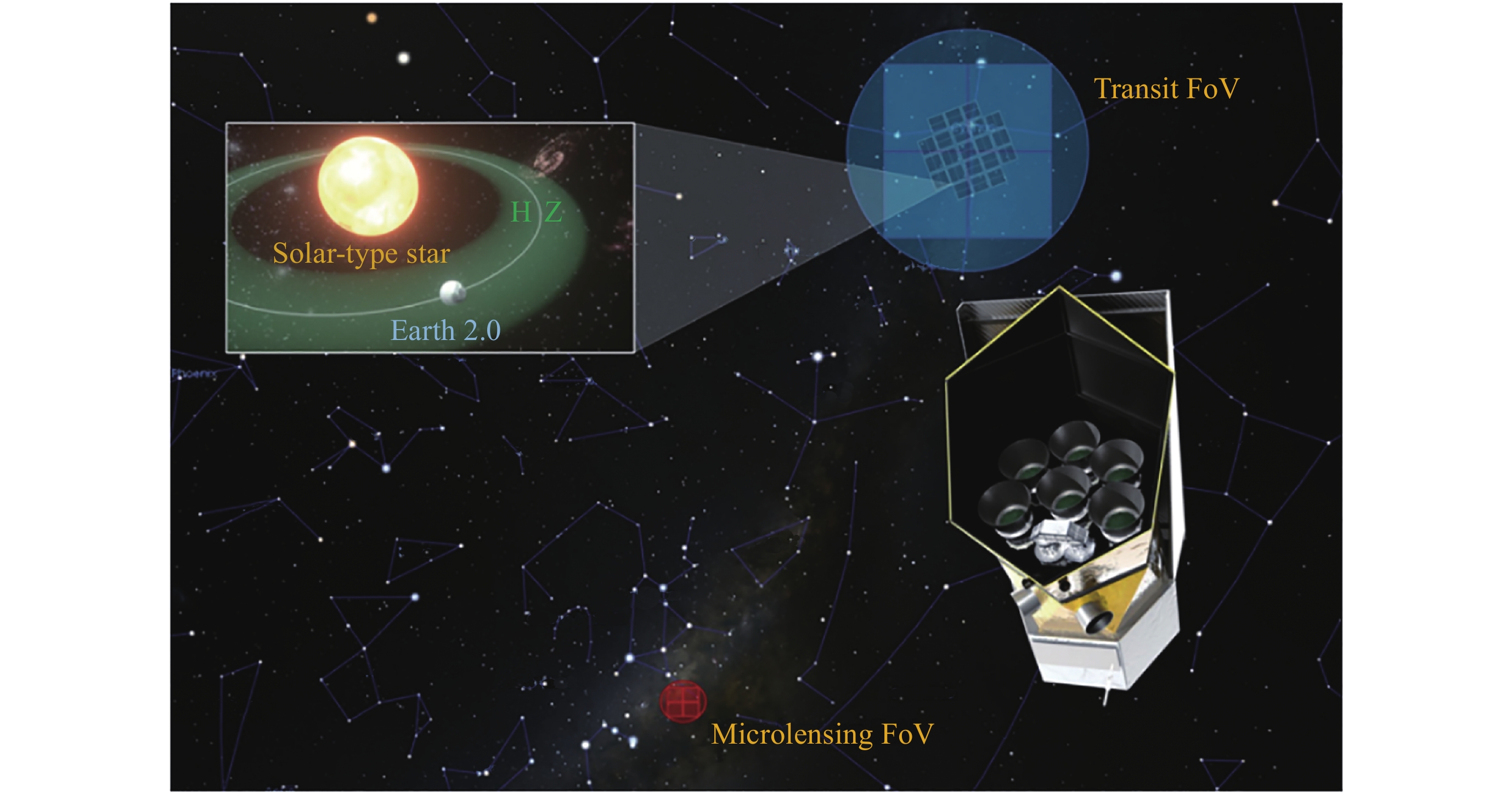
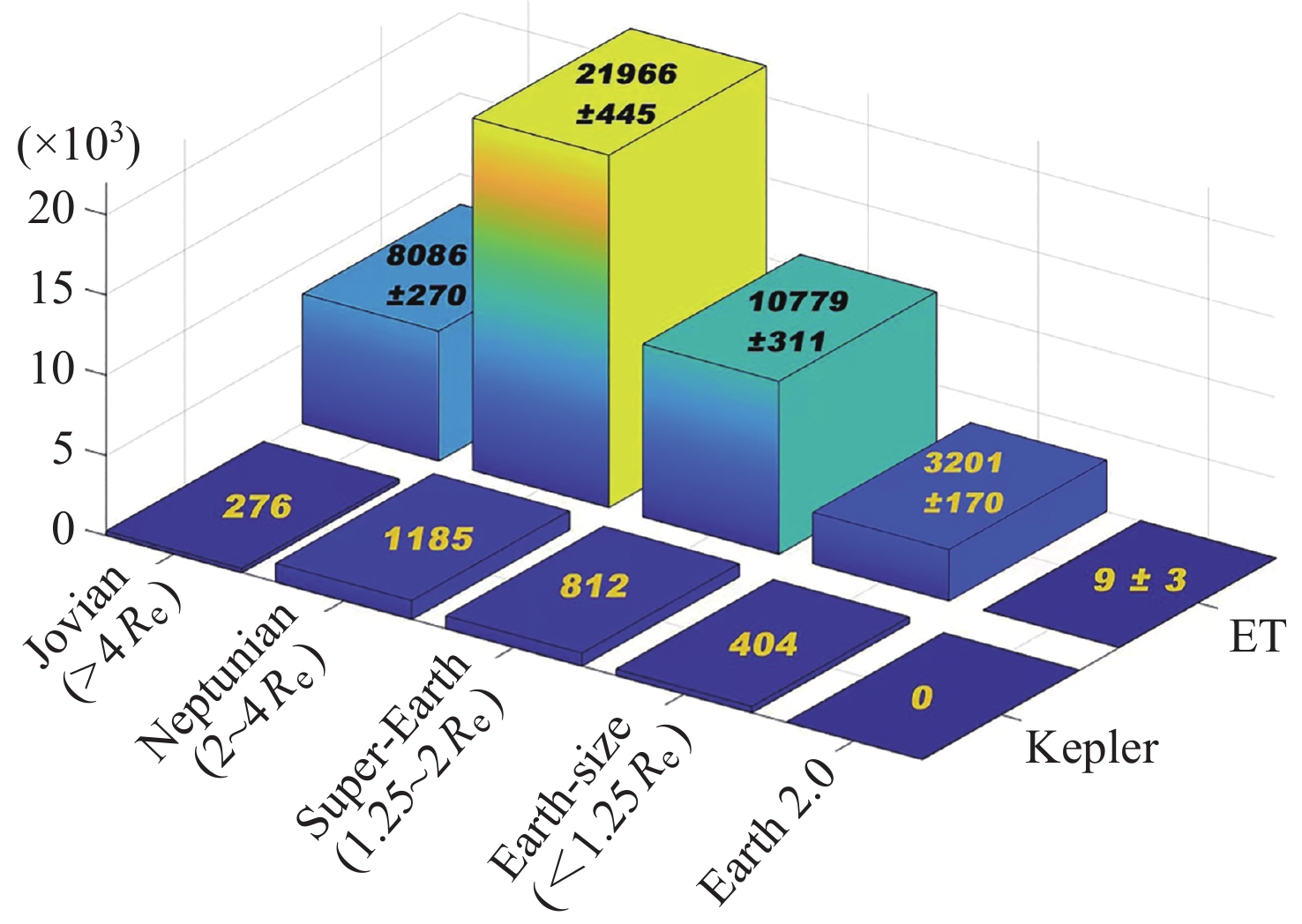
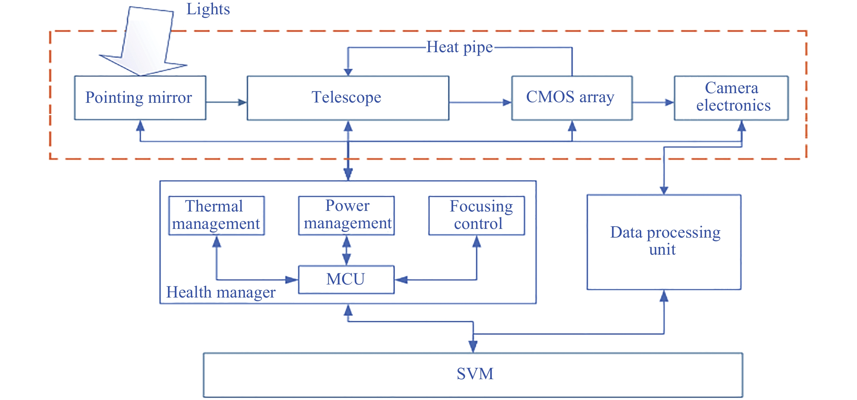
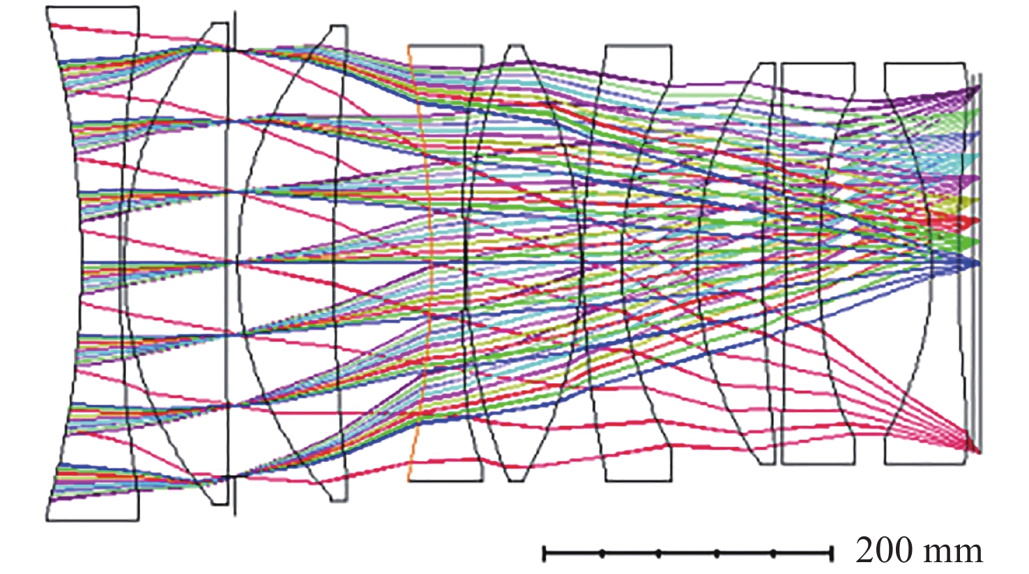
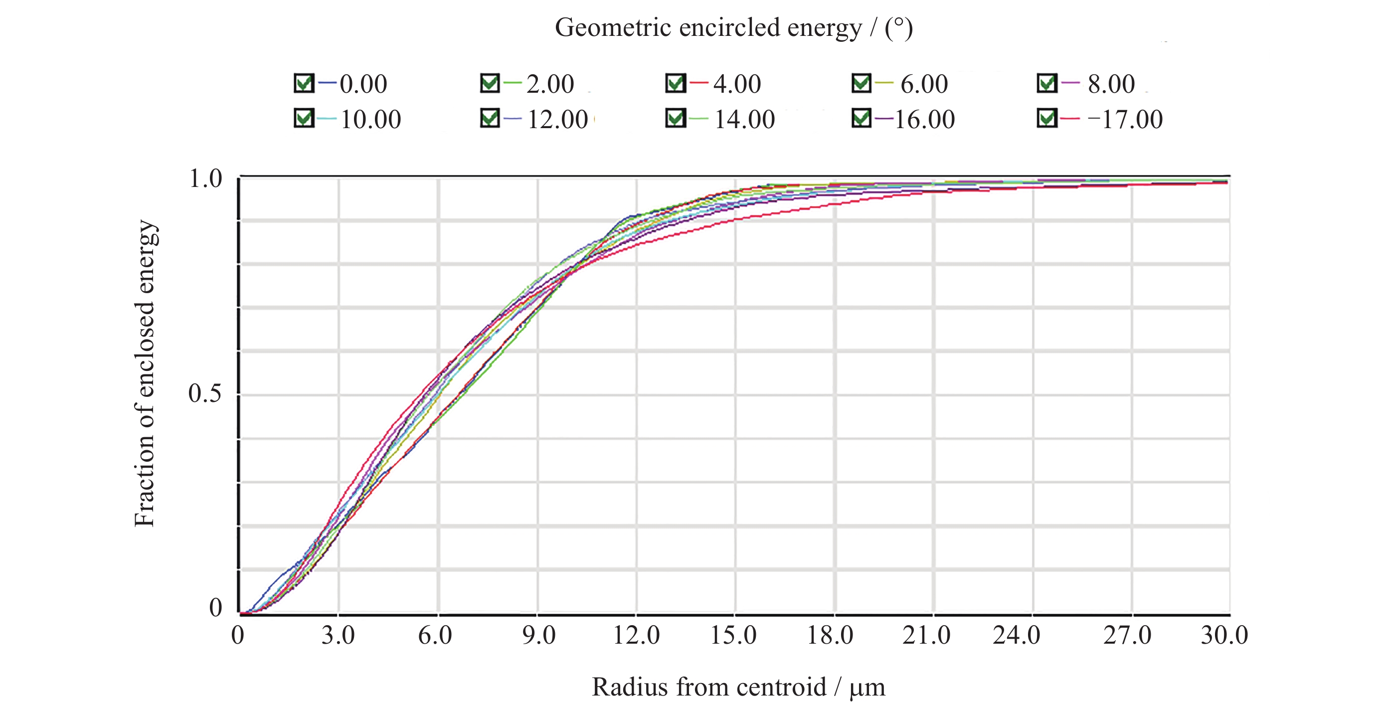
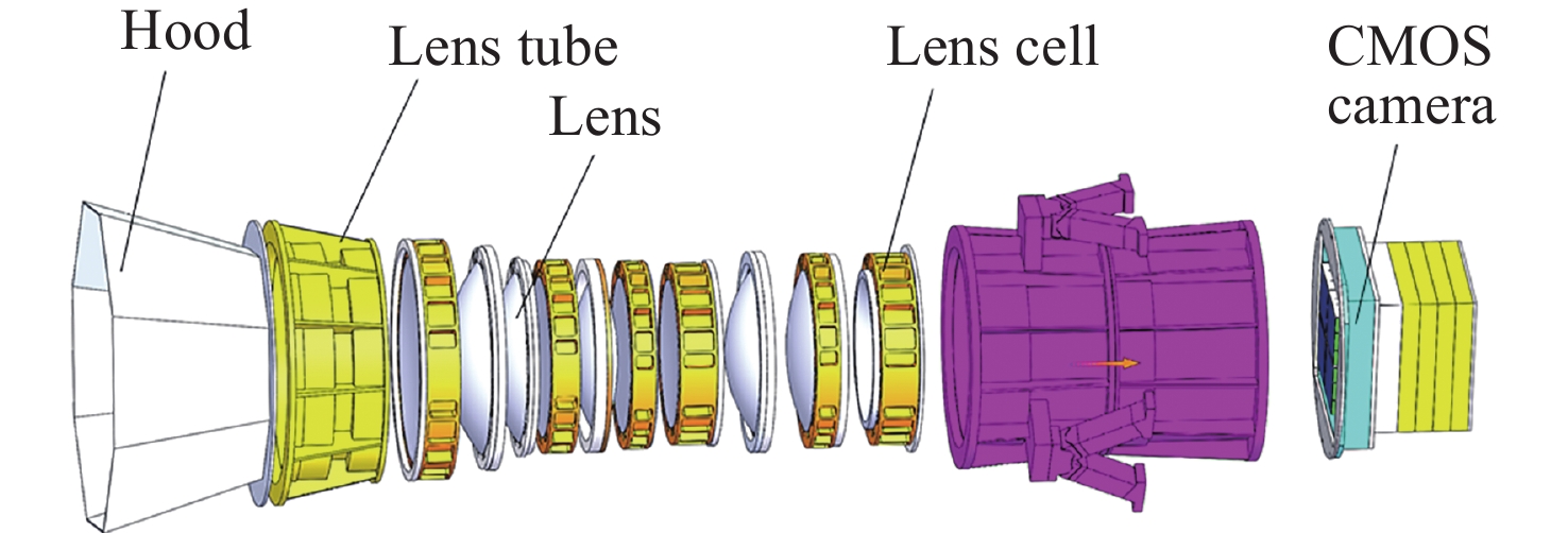
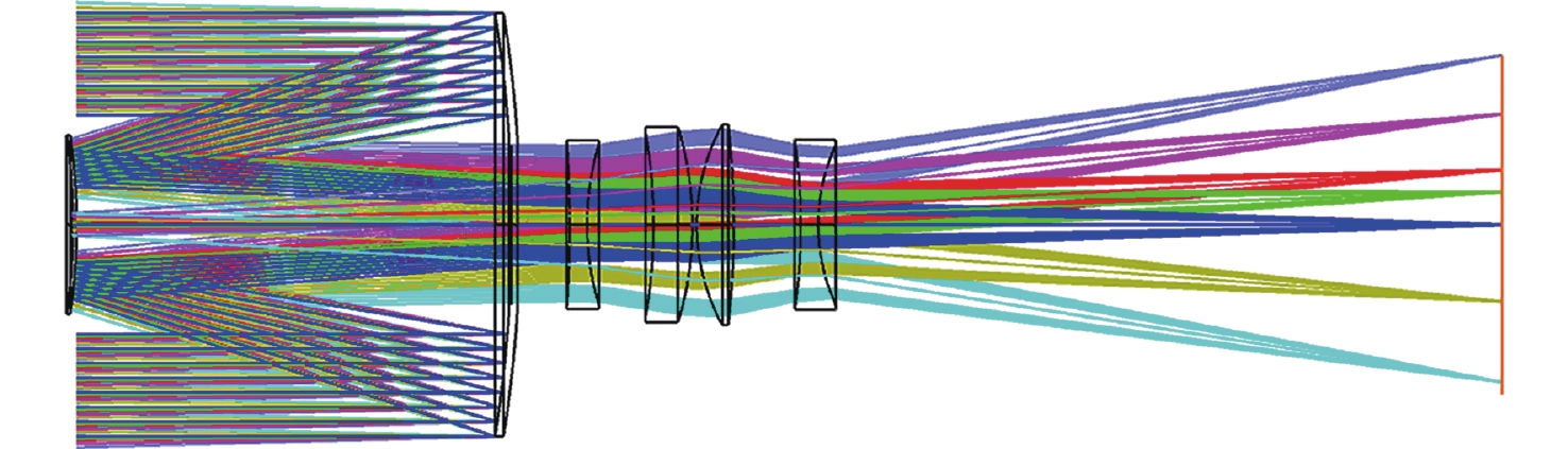
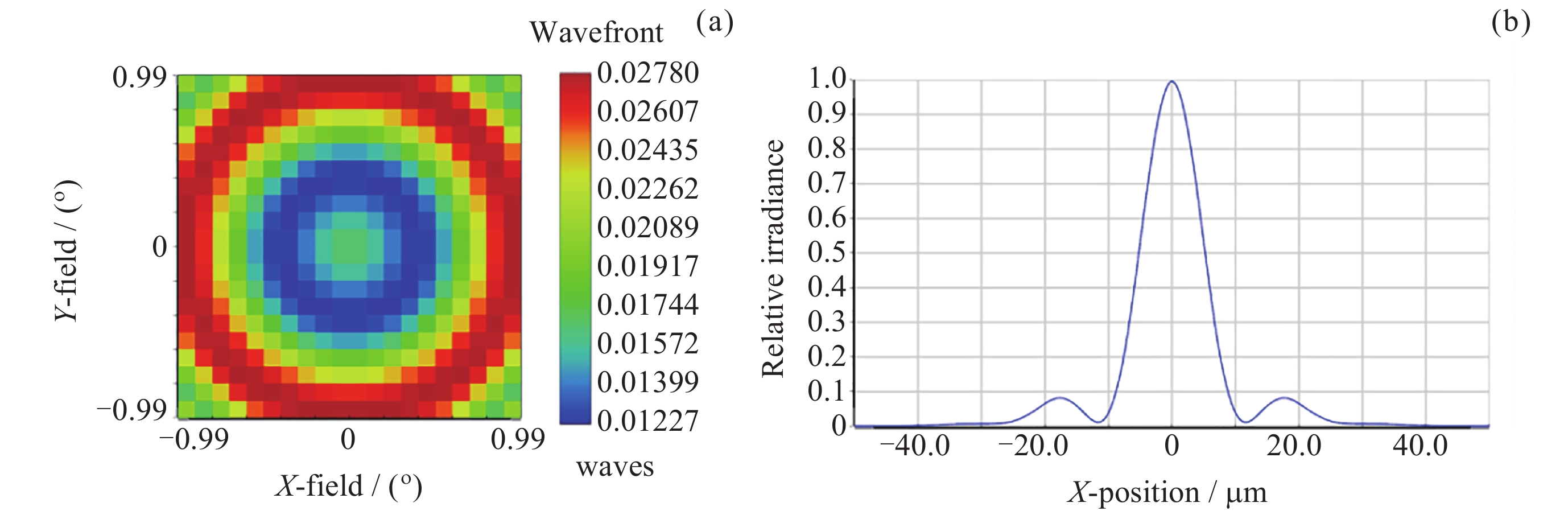
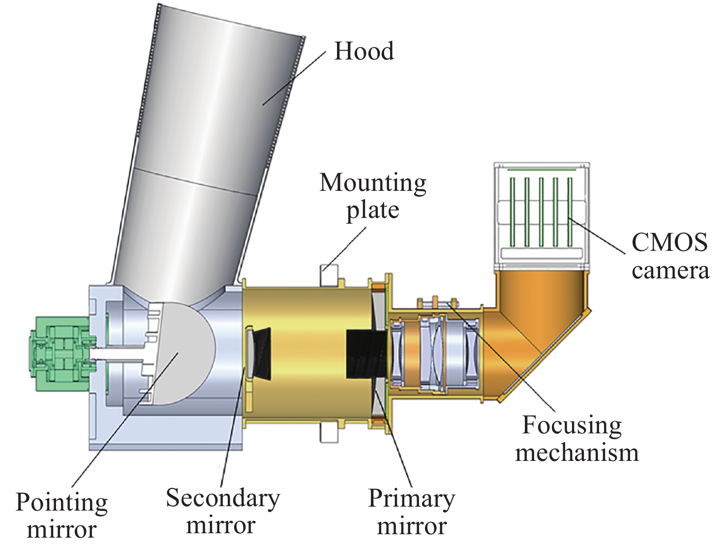
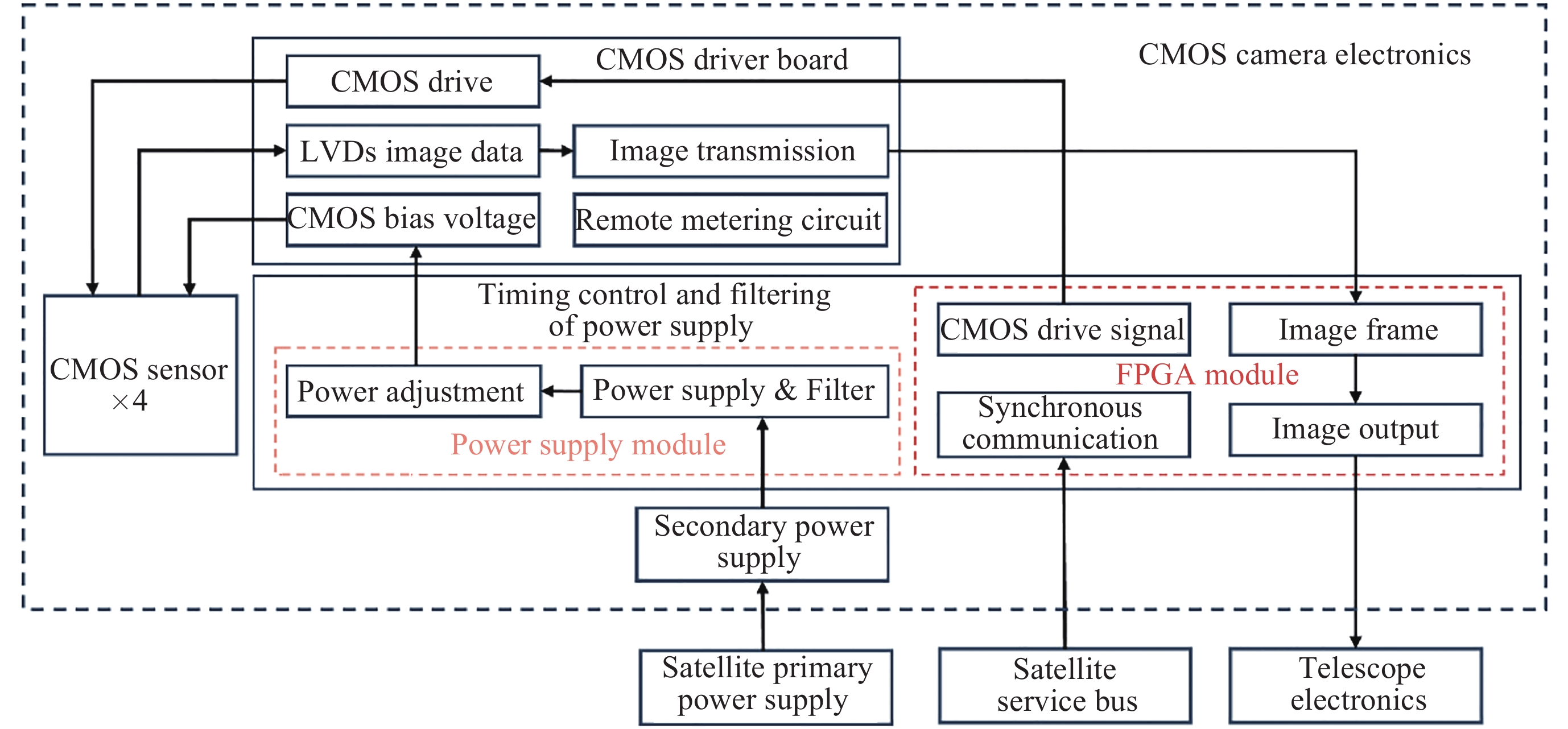
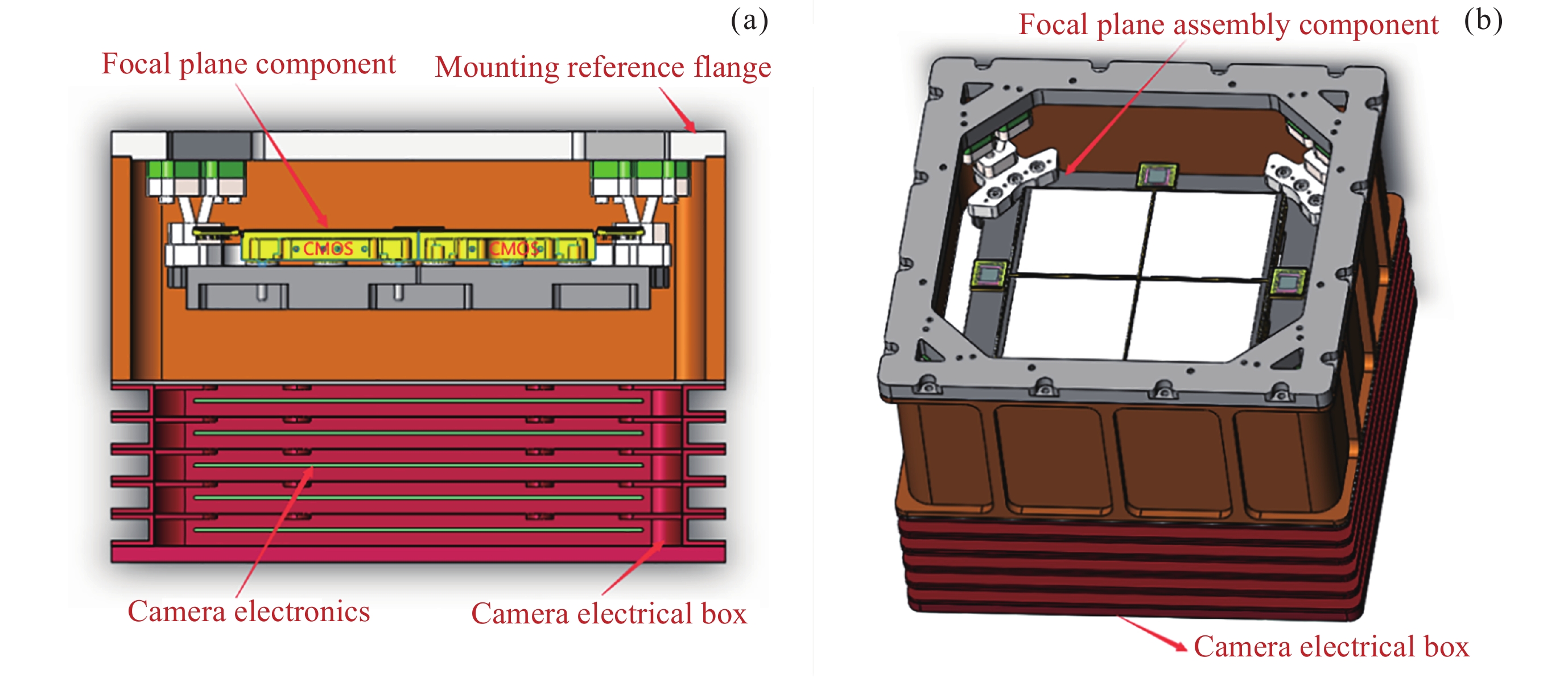
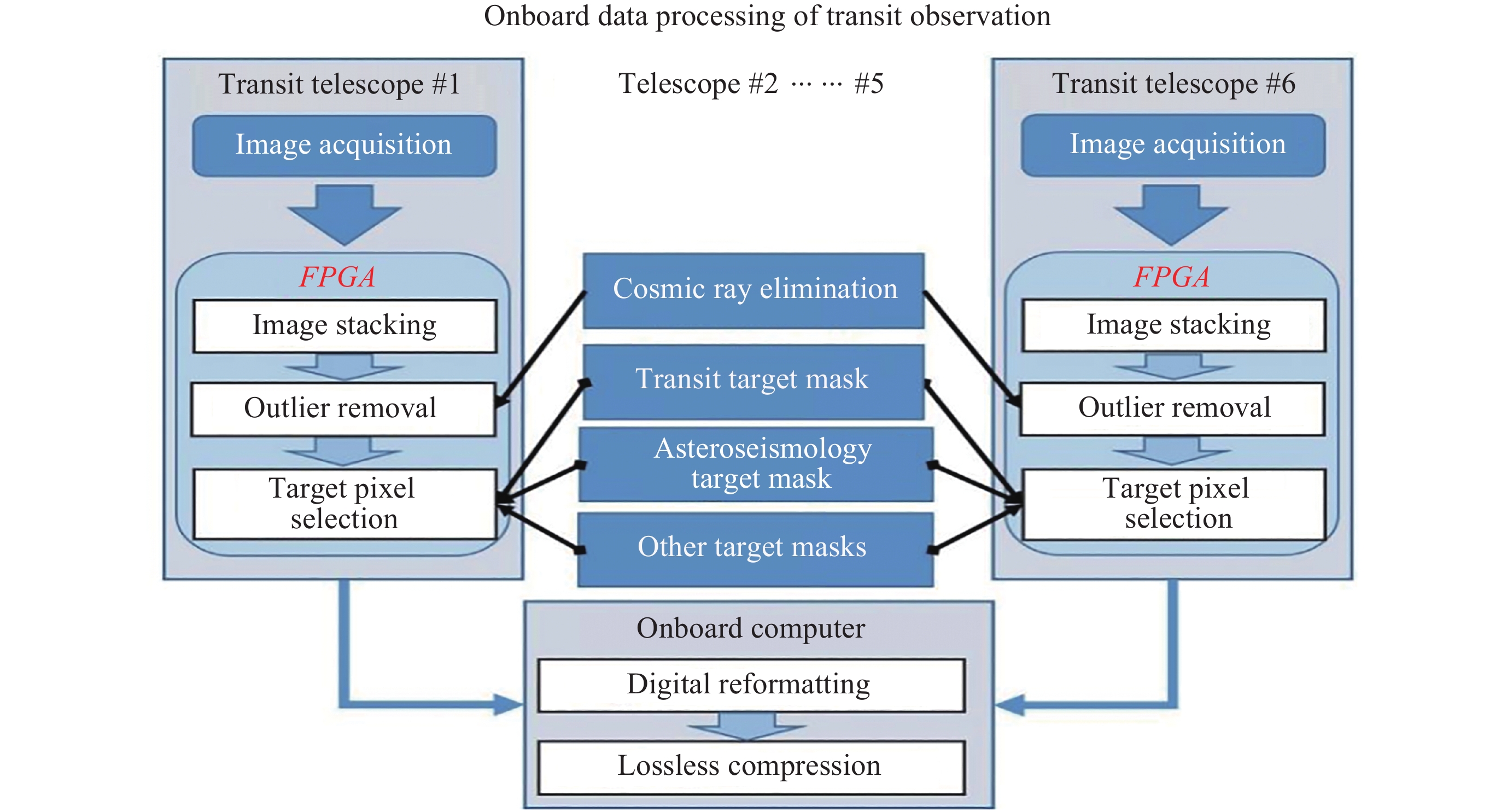
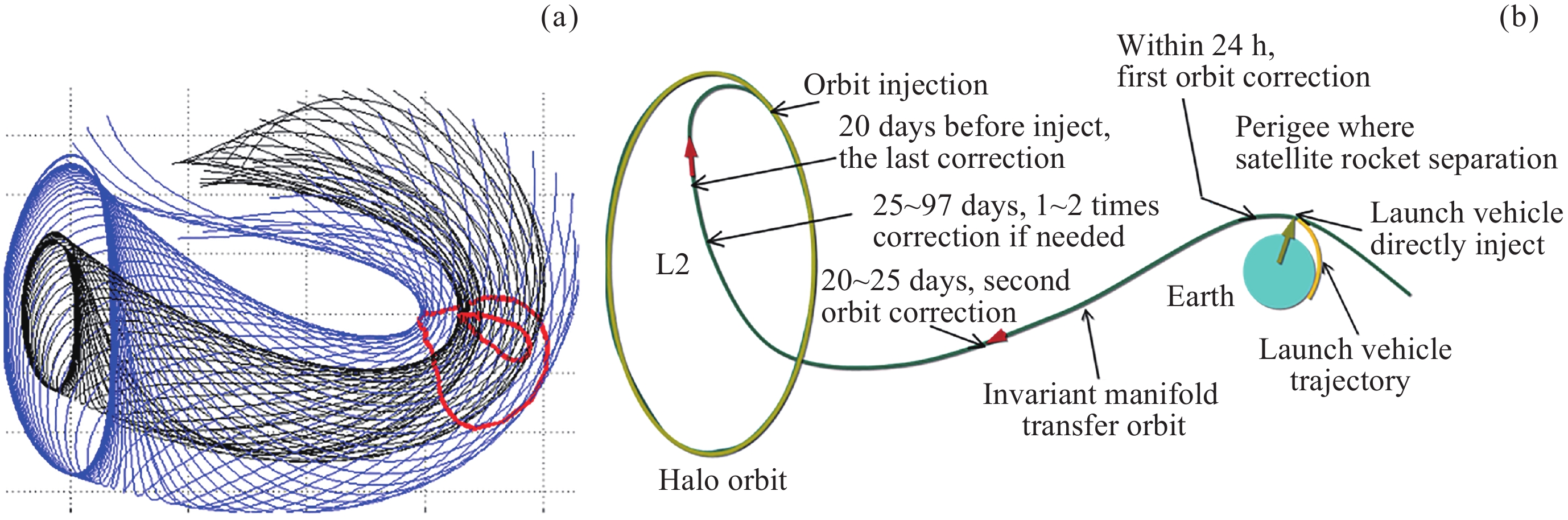
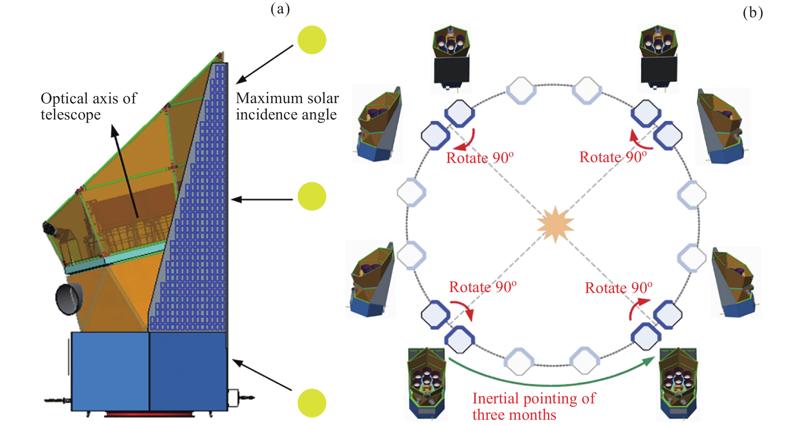
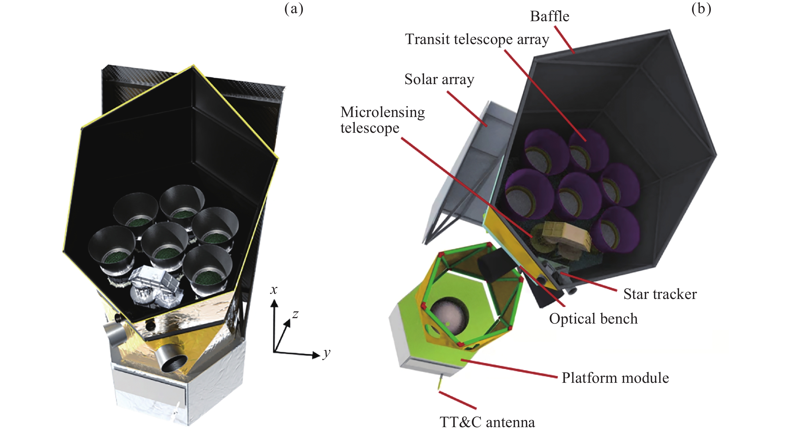
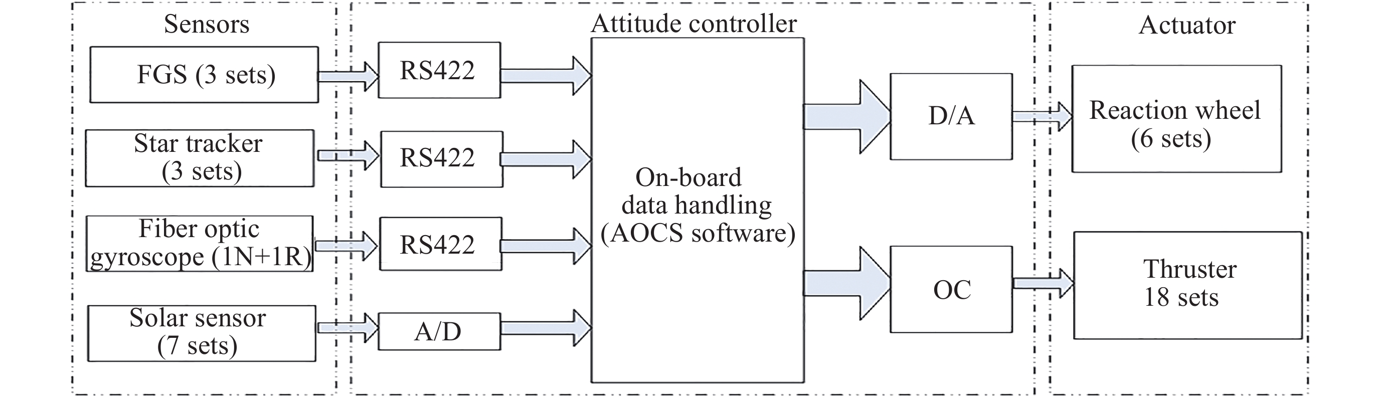
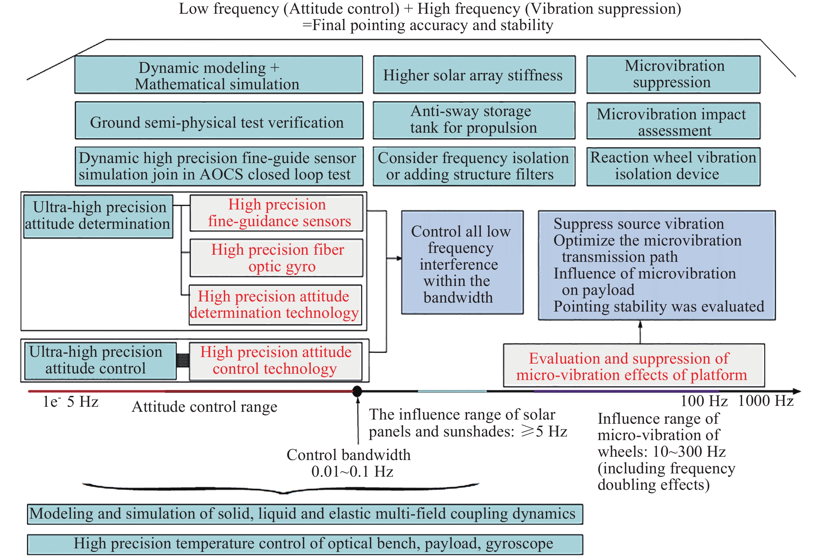
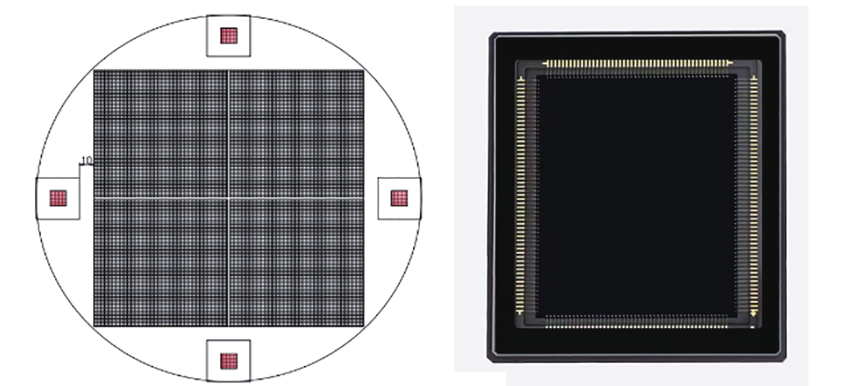
The Earth 2.0 (ET) mission will pioneer the international breakthrough in the frontier scientific issue of the existence and evolution of Earth 2.0s (or exo-Earths) in the origin of life by adopting the key technology of ultra-high precision photometry with a large field of view in space. The ET mission will deploy a space observatory consisting of six wide-field transit telescopes and one micro-lensing telescope in a halo orbit at the Sun-Earth Lagrange L2 point. Combining transit and micro-lensing methods, utilizing the ultra-large field of view and ultra-high precision optical photometry observations in space, the ET mission will for the first time discover historically significant Earth 2.0s and determine their occurrence rate. It will conduct the first large-scale survey of terrestrial-like and free-floating planets, discover free-floating Earth-mass planets and measure their occurrence rates, reveal the origins of Earth-like and free-floating planets, and provide candidates and new directions for the search for extraterrestrial life. The observational results, statistical studies, and theoretical tests of the ET mission will answer pressing frontier scientific questions such as “How common are Earth-like planets in the universe”, “How do Earth-like planets form and evolve” and “How do free-floating planets originate”. Follow-up observations of the Earth 2.0 samples discovered by the ET mission will precisely measure their mass, density, and atmospheric composition, contributing to an in-depth study of their habitability characteristics. Moreover, the study of the large number of various exoplanet samples newly discovered by ET, as well as tests of theories, will promote a deeper understanding of the formation and evolution of these types of planets. ET’s abundant high-precision, high-cadence, and long-baseline photometric data will advance research in fields such as asteroseismology, Galactic archaeology, time-domain astronomy, binary stars, and binary black holes.
Verification of Short-term Forecast for F10.7 Index and Ap Index
CHEN Anqin, LI Mu, GUO Jianguang, LIU Dandan, TANG Wei, ZHAO Haijuan
2024, 44(3): 425-436. doi: 10.11728/cjss2024.03.2023-0121
Abstract:
The National Center for Space Weather (NCSW) has been providing space weather forecasts for the next 24 h, 48 h and 72 h since 1 July 2004. In this paper, the average error, the average absolute error, the skill score, the median error and the interquartile range of error are used to verify the F10.7 index and Ap index forecasted by NCSW from 2005 to 2022. It was found that the F10.7 index forecasted by NCSW for the next 24 h, 48 h, and 72 h are usually smaller than the observed F10.7 index; the Ap index for the next 24 h is usually higher than the observed Ap index, while Ap index forecasted for the next 48 h and 72 h are usually lower than the observed Ap index. The higher the level of solar activity, the greater the forecast error of the F10.7 index is. However, the maximum forecast error of the Ap index occurs in the declining period of solar activity. In addition, we compared the forecasts of NCSW with the simple statistical models such as the persistence model, 14 days recurrence model, 14 days corrected recurrence model, 27 days recurrence model, and 27 days corrected recurrence model, and found that the forecast performance of NCSW is usually better than that of five simple statistical models. For the F10.7 index, the forecast performance of NCSW is slightly better than that of the persistence model, and significantly better than that of the four recurrence models. However, when the solar activity level is high, the persistence model's performance of the F10.7 index for the next 72 h is better than that of NCSW. For the Ap index, in most cases, the performance of NCSW is significantly better than that of statistical models. However, when geomagnetic disturbances are severe, the Ap index forecasted by the 27 days recurrence model is more accurate than that forecasted by NCSW.
Modeling Next 3-day Kp Index Forecasting with Neural Networks and Exploring the Application of Explainable AI
WANG Tingyu, LUO Bingxian, CHEN Yanhong, SHI Yurong, WANG Jingjing, LIU Siqing
2024, 44(3): 437-445. doi: 10.11728/cjss2024.03.2023-0107
Abstract:
The current operational needs of space weather forecasting strongly require accurate predictions of the future 3-day Kp index. Such forecasts involve a multitude of predictors, including physical parameters observed at the Earth-Sun L1 point and historical characteristics of the Kp index. Therefore, previous research primarily relied on statistical or empirical methods for prediction. However, the complex coupling of multiple parameters during geomagnetic storm events has made it challenging to quantify the contributions of various predictors to Kp index forecasting over a 3-day timescale, hindering further improvements in forecast accuracy. This study builds a 3-day Kp index forecasting model based on neural network modeling and utilizes explainable AI (Artificial Intelligence) algorithm, specifically the integrated gradient algorithm, to quantify the contributions of individual predictor. The research results indicate that the southward interplanetary magnetic field contributes significantly to Kp index prediction, accounting for 37.15% of all factors, making it the primary contributor. Following this, solar wind speed contributes 15.73%, underscoring the model's ability to capture parameters aligned with physical characteristics as the primary predictive factors during training. The contribution of historical characteristics of Kp index (recurrence characteristics) gradually increases with the forecasting horizon and reaches 68.06% at a lead time of 3-day. This substantiates the strong predictive capabilities of the AI model in forecasting geomagnetic storm events induced by high-speed solar wind streams originating from coronal holes. Furthermore, this study conducts contribution analysis on two significant geomagnetic storm events that occurred in 2015 and 2017. It reveals that the predominant predictors contributing to each event differ. This underscores the model's capability to accurately capture the complex coupling of multiple parameters in geomagnetic storm forecasting. In conclusion, this research demonstrates that employing explainable AI algorithms can help quantify the contributions of various predictive factors to Kp index forecasting to some extent. This has the potential to enhance further research and improvements in 3-day Kp index AI forecasting models.
Statistical Analysis of Distributions of Electron Energy Spectra in the Earth’s Radiation Belts Based on Van Allen Probes Observations
WANG Jianhang, XIANG Zheng, MA Xin, GUO Deyu, DONG Junhu, LIU Yangxizi, HU Jingle, NI Binbin
2024, 44(3): 446-457. doi: 10.11728/cjss2024.03.2023-0070
Abstract:
The characteristics of energy spectra distributions of radiation belt electrons can help reveal the dominant physical mechanism behind the dynamics of the radiation belt. In this study, the temporal and spatial distribution characteristics of energy spectra of energetic electrons are statistically analyzed using the measurements from Van Allen probes during 2014–2018. The results show that most of the electron spectra in the radiation belt can be classified into three types: exponential, power-law and reversed spectra. The exponential spectra dominate in the outer radiation belt outside the plasmapause. The power-law spectra usually occur at higher L values and move to lower L values during geomagnetic storms. During quiet geomagnetic activity periods, the power-law energy spectra stay at the high L with longer time and higher proportion. The reversed energy spectra dominate at L>2.5 inside the plasmasphere. As the increase of plasmapause locations, more reversed energy spectra occur while the proportion of the exponential energy spectra decreases. During long-term quiet periods, electron fluxes near the peak of the reversed energy spectra (about 2 MeV) are relatively low to form obvious reversed spectral. The results also show that the peak location of reversed energy spectra is about 2 L inside the plasmapause while the peak location of exponential energy spectra is about 1.5 L outside the plasmapause. Appearances of power-law energy spectra are related to substorm injections of electrons. Stronger magnetic storms produce wider L ranges where reversed energy spectra are replaced by exponential spectra. During quiet times, exponential energy spectra inside the plasmapause are replaced by reversed energy spectra due to pitch angle scattering produced by plasmaspheric hiss waves.
Lightweight Automatic Detection Model for Lightning Whistle Waves Based on Improved YOLOv5
LU Chao, ZEREN Zhima, YANG Dehe, SUN Xiaoying, LÜ Fangxian, RAN Zilin, SHEN Xuhui
2024, 44(3): 458-473. doi: 10.11728/cjss2024.03.2023-0067
Abstract:
This project proposes an improved YOLOv5 detection algorithm YOLOv5 Upgraded. To address this issue, the study proposes an improved YOLOv5 detection algorithm called YOLOv5-Upgraded.The model takes into account the vector angle between the predicted edge and the real edge, The model replaces the loss function CIoU (Complete IoU) with SIoU (Scylla IoU); at the same time, in order to avoid phenomena such as gradient disappearance, gradient explosion, and neuron necrosis during network training, the activation function SiLU (Sigmoid-weighted Linear Unit) is replaced with Mish with better gradient flow; The CA attention mechanism is inserted into the backbone network to help the model identify the Lightning whistler waves more accurately and greatly reduce the missed detection rate. The study is based on the VLF-band data of CSES Satellite SCM with 2.4 seconds time window to intercept data, and 1126 time-frequency map data sets are obtained by band-pass filtering and short-time Fourier transform, and then expanded to 7882 images by image enhancement operations, of which 7091 are used as training set and 791 are used as test set. Experimentally, the average mean accuracy (mAP) of the improved YOLOv5-based model is 99.09% and the Recall is 96.20%, which are improved by 2.75% and 5.07% compared with the plain YOLOv5s, and 5.89% and 9.62% compared with the time-frequency map-based YOLOv3 model. The size of LSTM based on the speech processing technology lightning whistler waves recognition model is 82.89MB, while the YOLOv5-Upgraded model is only 13.78 MB, saving about 83.38% of memory resources. It is shown that the model greatly reduces the leakage problem of Lightning whistler waves, achieves better results in test set, and its lightweight features are easy to deploy to satellite devices, which greatly improves the possibility of satellite recognition.
Comparison of FY3D/GNOS Atmospheric Occultation Detection Temperature with TIMED/ SABER Temperature and NRLMSISE00 Model Temperature
LIU Hongshan, XU Jiyao, BAI Weihua, HE Jieying, SUN Longchang, ZHU Yajun, YUAN Wei, GAO Hong
2024, 44(3): 474-487. doi: 10.11728/cjss2024.03.2023-0072
Abstract:
The accurate detection of atmospheric temperature is of great significance for studying the structural characteristics and dynamic processes of the middle and upper atmosphere. The GNOS (Global Navigation Satellite System Occultation Sounder) mounted on the FY3D has been carrying out atmospheric sounding since 15 November 2017. The purpose of this study is to evaluate the atmospheric temperature data products of the FY3D satellite. This study was conducted to comparatively analyze the atmospheric temperature data within the range of 12~100 km based on FY3D occultation observation data for 3 years from January 2019 to December 2021, with the aid of TIMED/SABER detection data and NRLMSISE00 atmospheric model data. The SABER-FY3D temperature deviation (TSABERTFY3D) and NRLMSISE00-FY3D temperature deviation (TNRLMSISE00TFY3D) and their distribution with latitude, season, and the difference between the northern and southern hemispheres were analyzed. The results show that the three sets of temperature data have generally consistent trend with change in height. SABER-FY3D temperature deviation is positive (0~1.8 K) in the altitude range of 12~30 km, and as the altitude increases, the temperature deviation increases from 0 K at 30 km to $ - $11.6 K at 77 km. NRLMSISE00-FY3D temperature deviation is positive (0~4.4 K) in the stratosphere, and negative ($ - $2~0 K) in the mesosphere and low thermosphere. Both temperature deviations show significant variations with latitude and season. Below 60 km, SABER-FY3D temperature deviation is smaller in the low-latitude region ($ - $3.8~1.8 K) and larger in the high-latitude region ($ - $12~1.6 K), smaller in summer ($ - $0.5~2.2 K) and larger in winter ($ - $6.2~1 K); NRLMSISE00-FY3D temperature deviation is just the opposite, smaller in the high-latitude region ($ - $1.6~2.4 K) and larger in the low-latitude ($ - $3.9~6.1 K), smaller in winter ($ - $2~2.2 K),, and larger in summer($ - $1.3~7.1 K). The zero deviation lines of the two types of monthly average temperature deviations show characteristics of being higher in spring and summer and lower autumn and winter in both hemispheres. In the winter, in the altitude region of 40~60 km, the negative deviation of the SABER-FY3D average temperature in the northern hemisphere is more obvious than that in the southern hemisphere.
Multiscale GIC Prediction Based on Improved CNN-BiLSTM Model and Geomagnetic Monitoring Data
LAN Dongliang, CHEN Yanyun, WU Ying, ZHAO Miao, WANG Liang, WU Weili, HUANG Chong
2024, 44(3): 488-499. doi: 10.11728/cjss2024.03.2023-0084
Abstract:
The GIC generated by solar storms driving in power system networks can affect the safe operation of power equipment and systems, and even lead to major power outages. Predicting the level of GIC in power grids can provide an important reference for power system protection measures, but research in this area continues to be insufficient. In order to solve this problem, a multi-scale GIC prediction method for large-scale power grids is proposed by combining Convolutional Neural Networks (CNN), Bidirectional Long and Short Term Memory (BiLSTM), and attention mechanisms, using relevant monitoring information of spatial weather. Firstly, based on the analysis of the mechanism of GIC generated by solar storms, a GIC prediction model is constructed; Secondly, a dual-channel GIC prediction architecture based on CNN-BiLSTM is proposed: first, local geomagnetic disturbance information is captured using CNN, then the global characteristics of geomagnetic storm disturbance information are synthesized using BiLSTM, and finally, the geomagnetic information fragments that play a key role in GIC are comprehensively evaluated using the multi-head attention mechanism, achieving the prediction of the power grid GIC. Using monitoring data of the DED geomagnetic station and the QGZH geomagnetic station during the giant magnetic storm from 00:00 LT-20:00 LT on 8 November 2004, the proposed method was applied to regression prediction of the GIC of the 500 kV Ling’Ao substation. After 220 rounds of training, the relative error of GIC prediction is within 12%, the accuracy is higher than the prediction results of other models.
Large-scale Plasma Vortex in the Magnetotail of Venus
CHAI Lihui, GUO Mengdan, TANG Xiaozhun
2024, 44(3): 500-510. doi: 10.11728/cjss2024.03.2023-0057
Abstract:
Using the observations by the Analyzer of Space Plasmas and Energetic Atoms on Venus (ASPERA-4) onboard Venus Express, Previous studies found A large-scale plasma vortices of solar wind hydrogen ions (H+) and Venus ionospheric oxygen ions (O+) in the magnetotail of Venus. The vortex is counterclockwise when viewed from the tail towards the planet. We conducted a statistical analysis of the ASPERA-4 moment data calibrated by Fedorov to investigate the plasma characteristics in Venusian magnetotail. The statistical results showed that there are large-scale vortices of the solar wind H+ and Venus ionospheric O+ in both the Venus-Solar-Orbital (VSO) and Venus-Solar-Electrical (VSE) coordinate systems, but there are clockwise. Considering that neither counterclockwise nor clockwise plasma vortices can generate a magnetic field consistent with the observed magnetic structure in the Venusian magnetotail, and no complete plasma vortex is observed in the Mars magnetotail with a magnetic structure similar to that of Venusian magnetotail, concluded that there may not be large-scale plasma vortices in the Venusian magnetotail, and that more satellite observations are needed in the future to investigate the plasma characteristics on Venus.
Research and Prospect of In-situ Construction Materials on Mars
CHENG Shanshan, SHE Wei, GAO Yuyue, ZHOU Yan, WEN Shifeng, ZHOU Cheng
2024, 44(3): 511-524. doi: 10.11728/cjss2024.03.2023-0137
Abstract:
Martian regolith has gradually become a consensus as an important in-situ natural resource for building habitats and infrastructure on Mars. As more and more research focusing on in-situ utilization of Martian regolith, this article provides a comprehensive review of construction materials based on Martian regolith. However, it is necessary to consider the vastly different environmental conditions on Mars compared to Earth, such as low gravity, near vacuum, large temperature differences, cosmic ray radiation and so on. Similarly, due to the unique chemical composition, particle size, porosity, as well as thermal and mechanical properties of Martian regolith, it also brings several certain difficulties for in-situ production of construction materials on Mars. As a result, based on the extreme environment of Mars and the special properties of Martian regolith, this article provides a detailed overview of the preparation process and physical and mechanical characteristics of in-situ construction materials. Then, the research progress in two aspects of various Martian regolith-based concrete materials (including sulfur concrete, polymer concrete, geopolymer concrete, hydrogel-based concrete), Martian regolith-based melting and sintering materials is further emphasized. Moreover, this article systematically compares the preparation conditions and in-situ utilization rates of each construction material and analyzes both the advantages and weakness of their preparation processes in the special Martian environment. Finally, the problems and limitations of the above-mentioned materials in Martian in-situ construction are pointed out, including difficulties in production of polymer concrete, high energy consumption during melting and sintering processes, and insufficient service performance of construction materials in Martian environments. Accordingly, in order to provide useful references for the realization of in-situ construction on Mars in the future, the development direction of construction materials has been proposed in three aspects, which are the improved methods of anhydrous concrete represented by polymer concrete, optimization of melting and sintering processes and development of new materials suitably adapted to the environment.
Research Progress of Spaceflight Rodent Culture Devices and Experimental Techniques
ZHANG Jingjing, LÜ Yong, ZHANG Tao, LIU Fangwu
2024, 44(3): 544-555. doi: 10.11728/cjss2024.03.2023-0096
Abstract:
Space animal experiments constitute an integral component of human space life science research. Historically, these experiments have made significant contributions to the exploration of the life phenomena and activity patterns of Earth-based organisms within the spaceflight environment, as well as to the sustainable development of manned spaceflight. With the development of aerospace engineering, astronauts stay in space longer and longer. To address the health problems of human spaceflight, rodent spaceflight experiments have been carried out to study the effects of the space environment on living organisms, thereby providing crucial physiological and medical data for human spaceflight. In this work, the spaceflight rodent culture devices developed by foreign countries are investigated. The rodents’ survival status and the causes of death are analyzed, and the shortcomings and improvements of the culture devices are summarized. Then the relevant spaceflight rodent experimental technologies, including before launch, in orbit, and after returning to the ground, are investigated. This work aims to provide references for the design of China’s spaceflight rodent culture devices and rodent experiments.
International Lunar Research Station Communication Based on Satellite Double Relay
WANG Zhenhe, SUN Baosheng, LIU Yonghua, ZHANG Limin, LI Peng, SHANGGUAN Yong, WANG Jian, LI Chao, SHI Jiangbo, YAO Zengli
2024, 44(3): 592-605. doi: 10.11728/cjss2024.03.2023-0129
Abstract:
In 2021, China proposed the collaborative construction of the International Lunar Research Station with relevant countries, international organizations, and partners, which attracted wide attention from many parties, and the construction of the International Lunar Research Station project proceeded smoothly as planned. Upon completion, maintaining seamless communication with the ground control center will be crucial. However, foreign stations in China’s ground deep space TT&C network may pose long-term risks such as reducing availability and affecting full-time communication between the lunar research station and the ground control center. To address this, a concept of Queqiao-TL satellite double relay communication is proposed based on China’s lunar exploration status present and actual design of the TL relay satellite system. This idea has undergone coverage simulation analysis under various conditions from geometric visibility perspective and studied transmission systems, link designs, system composition, capture/tracking workflows for initial completion of full-time seamless communication research for the International Lunar Research Station using the satellite double relay technology. Under unified control of the ground control center, this approach provides a technical basis for achieving full-time seamless communication through comprehensive utilization of both ground deep space TT&C network and the satellite double relay technology. Furthermore, this concept can serve as a reference for spacecraft communications in Earth-Moon space and interplanetary exploration while promoting integration among China’s ground-based, space-based and deep space TT&C network.
Planetary Science
Numerical Validation of Subsurface Dielectric Property Estimation Based on Full Waveform Inversion at Chang’E-4 Landing Site
CHEN Shurui, FENG Yongjiu, TONG Xiaohua, TANG Panli, XU Xiong, WANG Chao, LIU Sicong, YANG Qiquan, XIAO Changjiang
2024, 44(3): 525-535. doi: 10.11728/cjss2024.03.2023-0115
Abstract:
Dielectric property is an important parameter that determines the propagation speed of radar wave in materials, which is widely used in stratigraphic division, regolith thickness inversion, radar model construction and water-ice detection. However, continuous impacts may cover the traces of important geological activities and hinder the exploration of lunar geological. In January 2019, China’s Chang’E-4 carried the Yutu-2 rover successfully landed at the Von Kármán crater (177.5991°E, 45.4446°S) in the South Pole-Aitken (SPA) basin. The Yutu-2 rover equipped with dual-frequency ground penetrating radar (Lunar Penetrating Radar, LPR). The subsurface radar diagram with fine vertical resolution provided by the Chang’E-4 LPR can deepen our understanding of the dielectric property of lunar subsurface materials. Full Waveform Inversion (FWI) method can fully utilize the kinematic and dynamic information of radar wave field and invert the dielectric property by constructing an initial dielectric model and continuously updating this model with comparison of the observed radar data. By comparing the simulation results of homogeneous dielectric model and stochastic equivalent media model to the Chang’E-4 LPR diagram, we selected the stochastic equivalent media model as the real model to simulate the subsurface dielectric profile at the Chang’E-4 landing site and valid the dielectric accuracy inversed by FWI method. Our results reported that FWI method can not only capture the dielectric perturbation in local scale, but also generate two-dimensional dielectric profile with high spatial resolution. The initial dielectric model is able to better characterize the dielectric properties after 79 FWI iterations, and the maximum inversion error of relative dielectric constant is limited to 0.2 (the objective function is minimized to 0.91% of the initial value). The stochastic equivalent medium model can effectively simulate the dielectric properties of the lunar regolith, and the radar simulation results based on it are close to the Chang’E-4 LPR radar diagram.
Microgravity and Space Life Science
Evolution Mechanism of Phase Change Materials Liquid-bridge Phase Transition and Thermocapillary Convection under Microgravity Conditions
ZHANG Yongchun, DONG Wenli, SUN Tao, GAO Yinyu, LI Zhirou, DUAN Wenhao, ZHOU Xiaoming
2024, 44(3): 536-543. doi: 10.11728/cjss2024.03.2023-0105
Abstract:
In order to reveal the flow characteristics and evolution law of PCM liquid-bridge phase transition under microgravity conditions, the evolution process of solid-liquid interface during PCM liquid-bridge phase transition under different working conditions was numerically studied based on numerical simulation method. The effects of different height-diameter ratio and temperature difference on the shape of liquid bridge, the evolution law of solid-liquid interface, phase transition velocity and thermal capillary flow were analyzed. The results show that under the condition of large temperature difference, the thermal capillary flow is more intense, the phase transition speed of the phase change material at the outer wall is faster, and the angle between the phase change interface at the outer wall and the wall is smaller. Under the condition of large aspect ratio, the same effect will be achieved, and more vortex cell structures will be generated, and the thermal capillary convection effect is more obvious. The results show that strengthening PCM phase transition through fluid interface thermal capillary effect under microgravity conditions is an effective method.
Space Exploration Technology
Orbital Transfer Problem on the Central Manifold of Libration Points
YANG Futao, ZHANG Hanqing
2024, 44(3): 556-569. doi: 10.11728/cjss2024.03.2023-0098
Abstract:
The Circular Restricted Three-body Problem (CR3BP) exhibits highly complex nonlinear dynamical characteristics in the vicinity of its libration points. The various periodic and quasi-periodic orbits within this region hold significant value for increasingly complex deep space exploration missions, offering more possibilities and flexibility in the design and control of mission trajectories. The issue of orbit transfers between these libration points warrants systematic investigation. To compute orbits around libration points, a numerical computation method based on escape time is proposed, enabling the unified calculation of various quasi-periodic orbits across a broad range of energy levels. Based on the manifold configuration of libration point orbit state points, a universal orbit maintenance strategy called state-adjoint techniques is proposed, yielding schemes that can sustain long-term stable operation of various libration point orbits. Building on extensive studies of invariant manifolds and Poincaré sections associated with numerous libration point orbits, a comprehensive solution has been designed to enable orbit transfers between libration points through pulse maneuvers. This method fully leverages the dynamical features of libration points and has been proven effective through simulation validation, offering new insights for research on libration point orbit transfers.
Remanence Model Estimation Method of Geomagnetic Navigation Carrier Based on Recursive Least Square Method
ZHU Minghui, GU Peng, GAO Dong
2024, 44(3): 570-584. doi: 10.11728/cjss2024.03.2023-0002
Abstract:
Geomagnetic navigation is a method of in-situ measurement of magnetic field by the magnetometer installed on the carrier platform to realize navigation. It is a passive navigation, which has the advantages of autonomy, strong anti-interference ability and no cumulative error. One of the difficulties in the application of geomagnetic navigation on moving platform is the influence of platform remanence on geomagnetic measurement, which seriously pollutes the measurement of magnetometer and becomes a key technology in the transformation of geomagnetic navigation to application. For example, the magnetic field distribution generated by ferromagnetic materials and the interference magnetic field generated by electrical equipment during work will pollute the measured value of the magnetometer, and then affect the accuracy of geomagnetic navigation. Aiming at the complicated problem of interfering magnetic field in geomagnetic measurement, this paper focuses on the effective measurement and estimation of the remanence of a moving platform. In order to realize effective measurement and estimation of remanence of moving platform, a method of differential measurement and estimation of remanence of moving platform based on recursive least square method is proposed. Firstly, the method is based on the conclusion that the carrier interference magnetic field value is only related to the distance between the measuring point and the magnetic dipole and the equivalent magnetic moment of the magnetic dipole in magnetic dipole theory, and the magnetic field distribution characteristics of the magnetic dipole. A remanence difference estimation model of moving platform based on built-in magnetometer array is derived, and the difference estimation model is solved by recursive least square method. Finally, a large number of simulation experiments show that the platform remanence estimation method can be measured and estimated by the built-in array magnetometer, which proves the effectiveness of the proposed method and lays a theoretical foundation for accurate geomagnetic navigation.
QX-1 GNOS M Radio Occultation Data Performance Analysis
LIU Zhiyong, LIU Sen, WANG Xi, ZHANG Shuiping
2024, 44(3): 585-591. doi: 10.11728/cjss2024.03.2023-0071
Abstract:
QX-1 GNOS M is the first small commercial Global Navigation Satellite System (GNSS) occultation sounder to achieve on-orbit compatibility with BeiDou, GPS, and Galileo systems. On 14 October 2021, at 18:51 LT, the Meteorological Satellite-1 (QX-1) was launched and entered orbit. Since its launch, this satellite has collected a large amount of observational data. This paper provides a detailed introduction to the composition of QX-1 GNOS M and conducts a statistical analysis of the occultation events and their global distribution on 17 August 2022. By comparing the occultation data from 17 August to 3 September with the NCEP reanalysis model, the detection penetration depth and refractivity accuracy of QX-1 occultation events were evaluated, and the reliability and consistency of the Galileo occultation data were tested. Preliminary analysis results show that after achieving three-system compatibility, the number of occultation events detected by QX-1 GNOS M increased by approximately 1.5 times compared to using only the GPS system. This result further confirms that the occultation data provided by different GNSS systems are consistent in accuracy. Additionally, the study indicates that, in a multi-system compatibility context, QX-1 GNOS M can provide richer and more accurate meteorological and atmospheric data.