Current Issue

2025 Vol. 45, No. 4

Review
Coronal Explorer for the Sun and Nearby Stars
TIAN Hui, BAI Xianyong, FENG Li, XIONG Ming, CHEN Yajie, HOU Zhenyong, WANG Yamin
2025, 45(4): 881-898. doi: 10.11728/cjss2025.04.2025-0060
Abstract:
We propose to launch the first Extreme-Ultraviolet (EUV) space science mission in China, the Coronal Explorer for the Sun and nearby Stars (CESS), to explore the sources of space weather both within and beyond the solar system, specifically the solar and stellar coronae. The CESS mission is designed to observe the Sun and nearby late-type stars from a single satellite platform. The spacecraft will operate in a 720-km-altitude sun-synchronous orbit, enabling continuous and uninterrupted solar coronal observations. Simultaneously, observations of nearby stars will be achieved using an alt-azimuth mount for precise pointing and long-term tracking, facilitating continuous monitoring of stellar coronae. The primary scientific objects of this mission are as follows. (1) Characterize the physical properties of the source regions of solar coronal outflows and eruptions through full-disk EUV spectroscopy of the Sun. (2) Fill the current observational gap in extrasolar EUV observations, detect stellar coronal eruptions through long-term EUV photometric and spectroscopic monitoring of the coronae of selected nearby late-type stars, and pioneer a new frontier in understanding extrasolar space weather (space weather in star-exoplanet systems). (3) Explore the role of space weather in the formation of a habitable world through point-source EUV observations of the Sun and other stars, and provide crucial clues for addressing the profound question: are we alone in the universe? To fulfill these scientific goals, the spacecraft will be equipped with four key science payloads: an EUV solar-disk spectrometer (comprising a Sun-as-a-star spectrometer and a multi-slit spectrometer with a full-disk field of view), an EUV spectroscopic coronagraph, a stellar EUV spectrometer, and a stellar EUV photometer. The CESS mission will contribute to the precise prediction of space weather in the solar system, uncover the origin of exosolar space weather, and offer crucial clues for the search for potentially habitable worlds and extraterrestrial life.
Major Advances in Aerospace Transition Zone Atmospheric Dynamics Research
SHENG Zheng, GUO Sheng, LENG Hongze, WANG Sicheng, SONG Junqiang
2025, 45(4): 899-912. doi: 10.11728/cjss2025.04.2025-yg01
Abstract:
The transitional zone bridging the domains of astronautics and aeronautics refers to the region between traditional aviation and space activities, specifically the atmospheric layer from 20 km to 150 km above the Earth’s surface. With the accelerated development of aerospace integrated space environment services, the modeling and forecasting of atmospheric dynamics in the aerospace transition zone have received increasing attention from various disciplines, while significant progress has been made on the microphysical processes and mechanisms of the aerospace transition zone atmospheric disturbances. This study reviews recent advances in atmospheric dynamics research for the aerospace transition zone. It summarizes studies on how solar radiation and polar particle precipitation affect this region within the Sun-solar wind-magnetosphere coupling chain. Then, we focus on summarizing the research progress of the coupling between Earth activities-lower atmosphere and the aerospace transition zone by four aspects of gravity waves, planetary waves, tidal waves, and typical lower atmospheric activities. Finally, it looks forward to the future development prospects of the aerospace transition zone and several key issues that need to be solved, providing a certain reference for scholars in atmospheric science and space physics.
Space Physics
Probing Solar Polar Regions
DENG Yuanyong, TIAN Hui, JIANG Jie, YANG Shuhong, LI Hao, CAMERON Robert, GIZON Laurent, HARRA Louise, WIMMER-SCHWEINGRUBER Robert F, AUCHÈRE Frédéric, BAI Xianyong, BELLOT RUBIO Luis, CHEN Linjie, CHEN Pengfei, CHITTA Lakshmi Pradeep, DAVIES Jackie, FAVATA Fabio, FENG Li, FENG Xueshang, GAN Weiqun, HASSLER Don, HE Jiansen, HOU Junfeng, HOU Zhenyong, JIN Chunlan, LI Wenya, LIN Jiaben, NANDY Dibyendu, PANT Vaibhav, ROMOLI Marco, SAKAO Taro, KRISHNA PRASAD Sayamanthula, SHEN Fang, SU Yang, TORIUMI Shin, TRIPATHI Durgesh, WANG Linghua, WANG Jingjing, XIA Lidong, XIONG Ming, YAN Yihua, YANG Liping, YANG Shangbin, ZHANG Mei, ZHOU Guiping, ZHU Xiaoshuai, WANG Jingxiu, WANG Chi
2025, 45(4): 913-942. doi: 10.11728/cjss2025.04.2025-0054
Abstract:
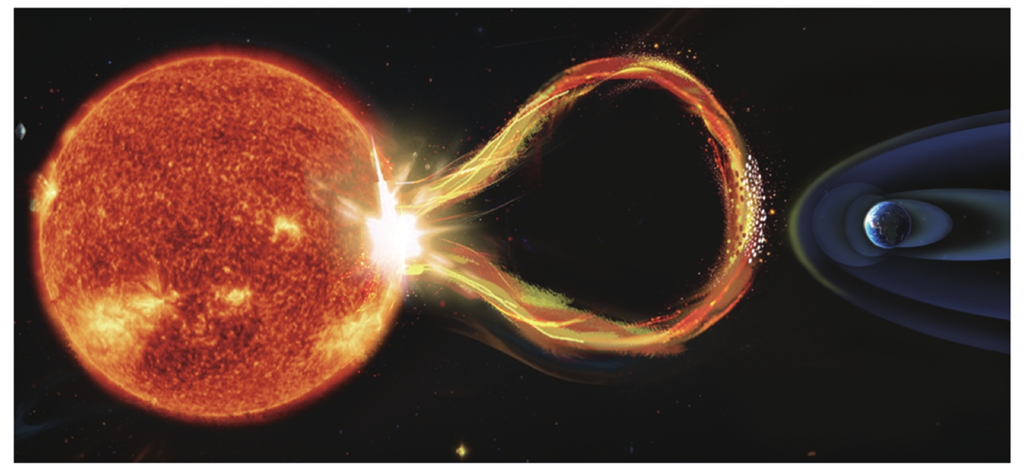
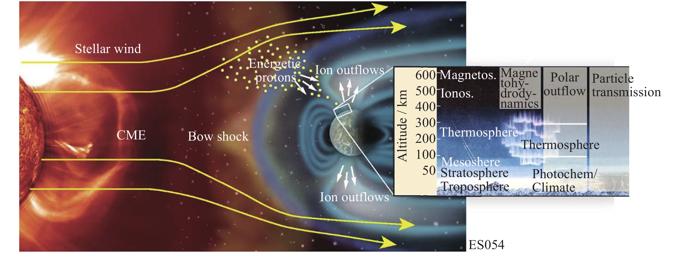
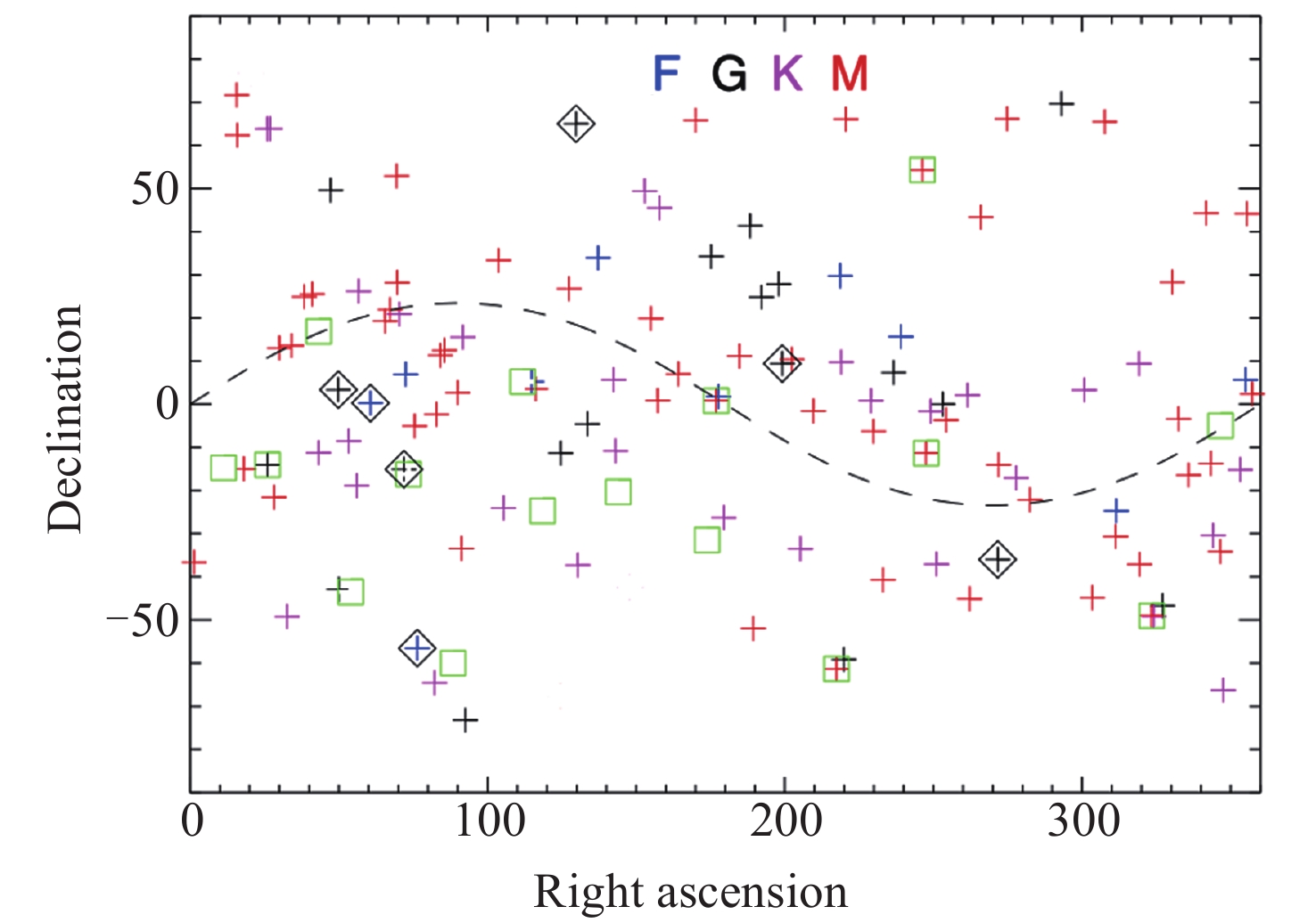
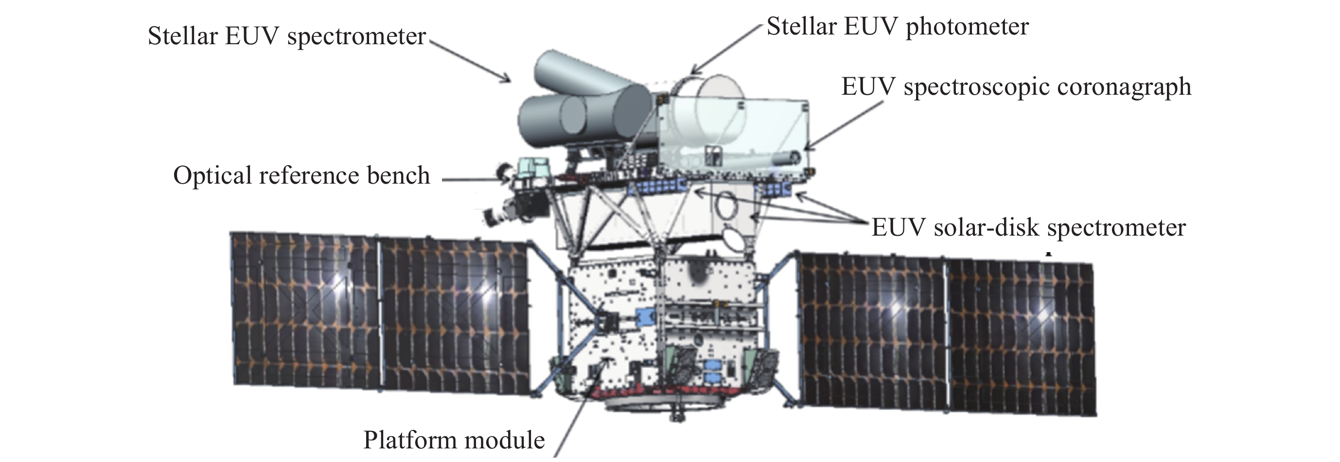
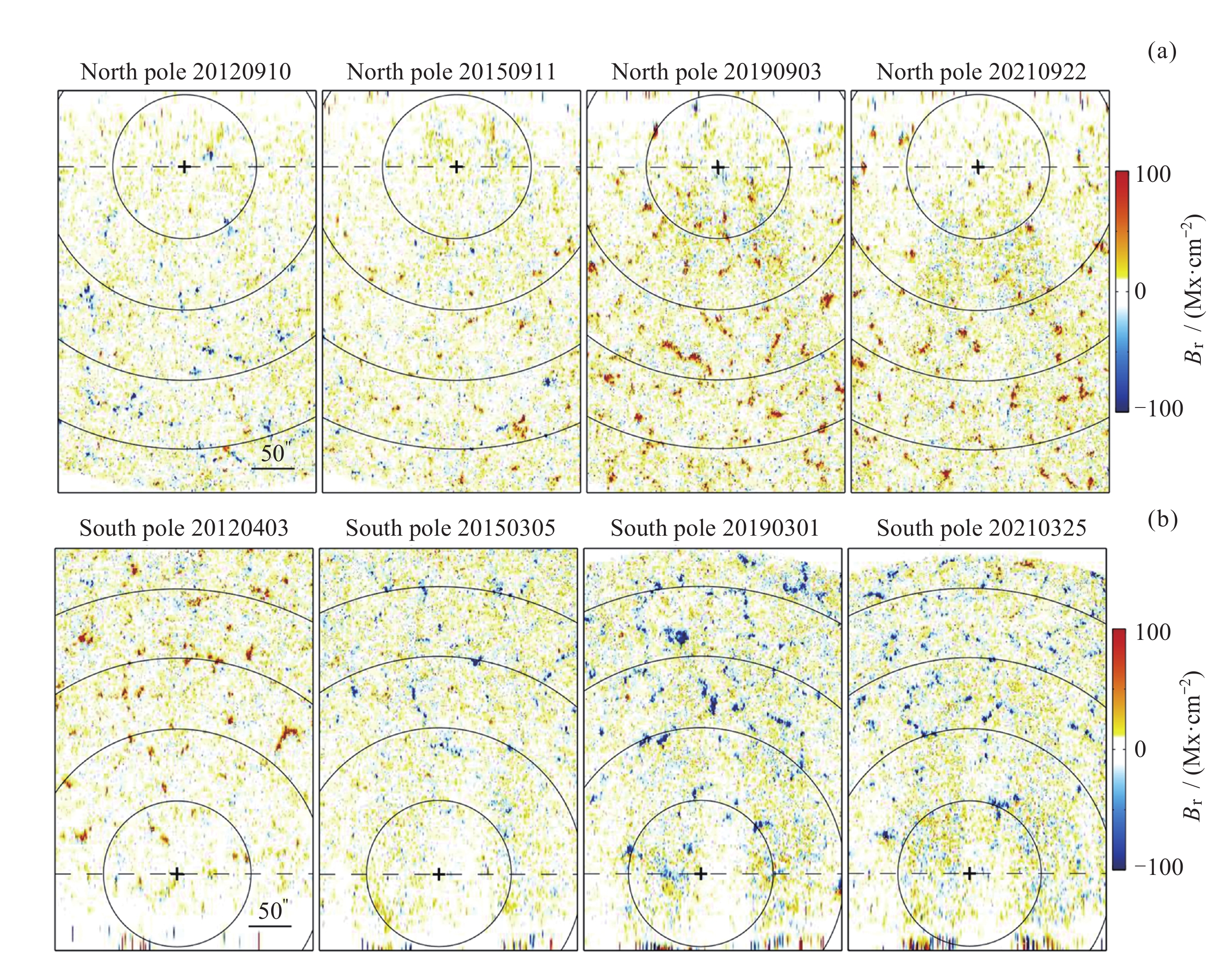
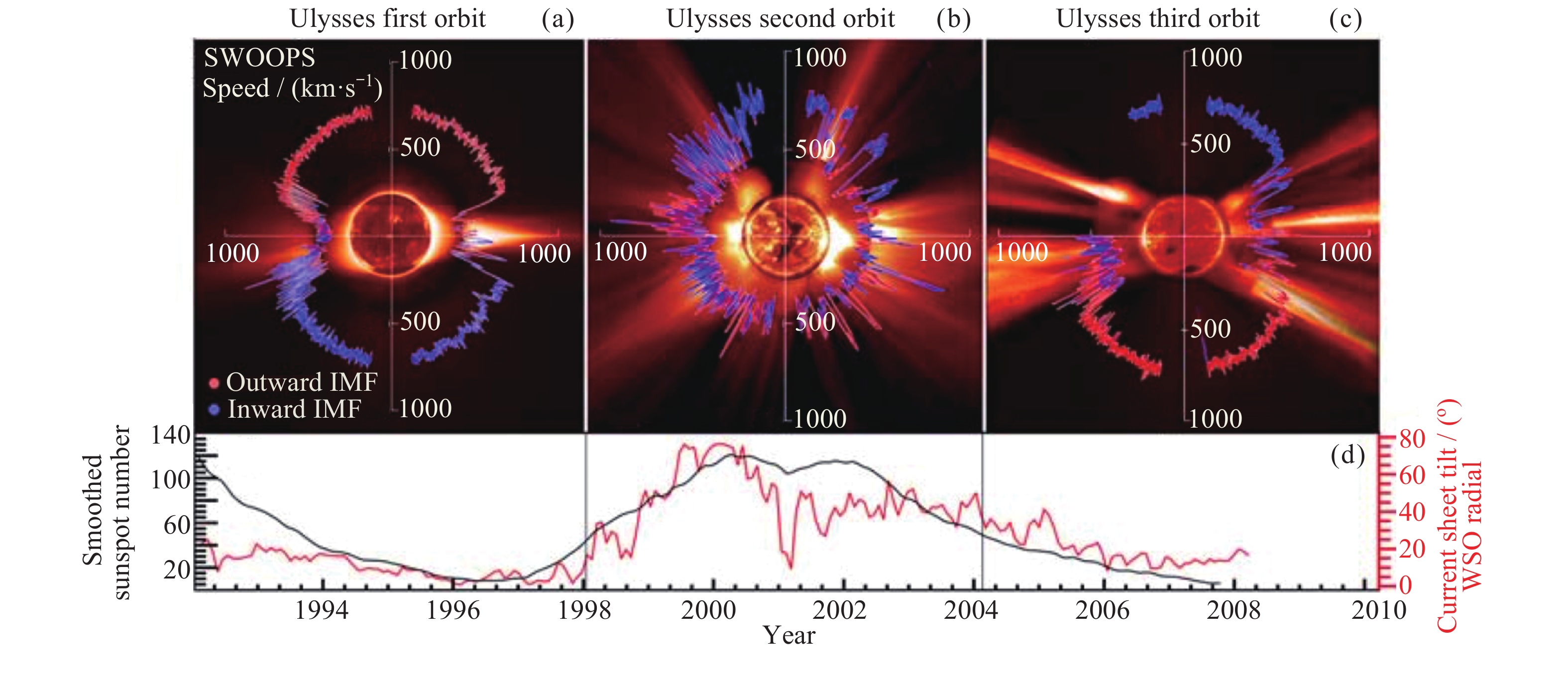
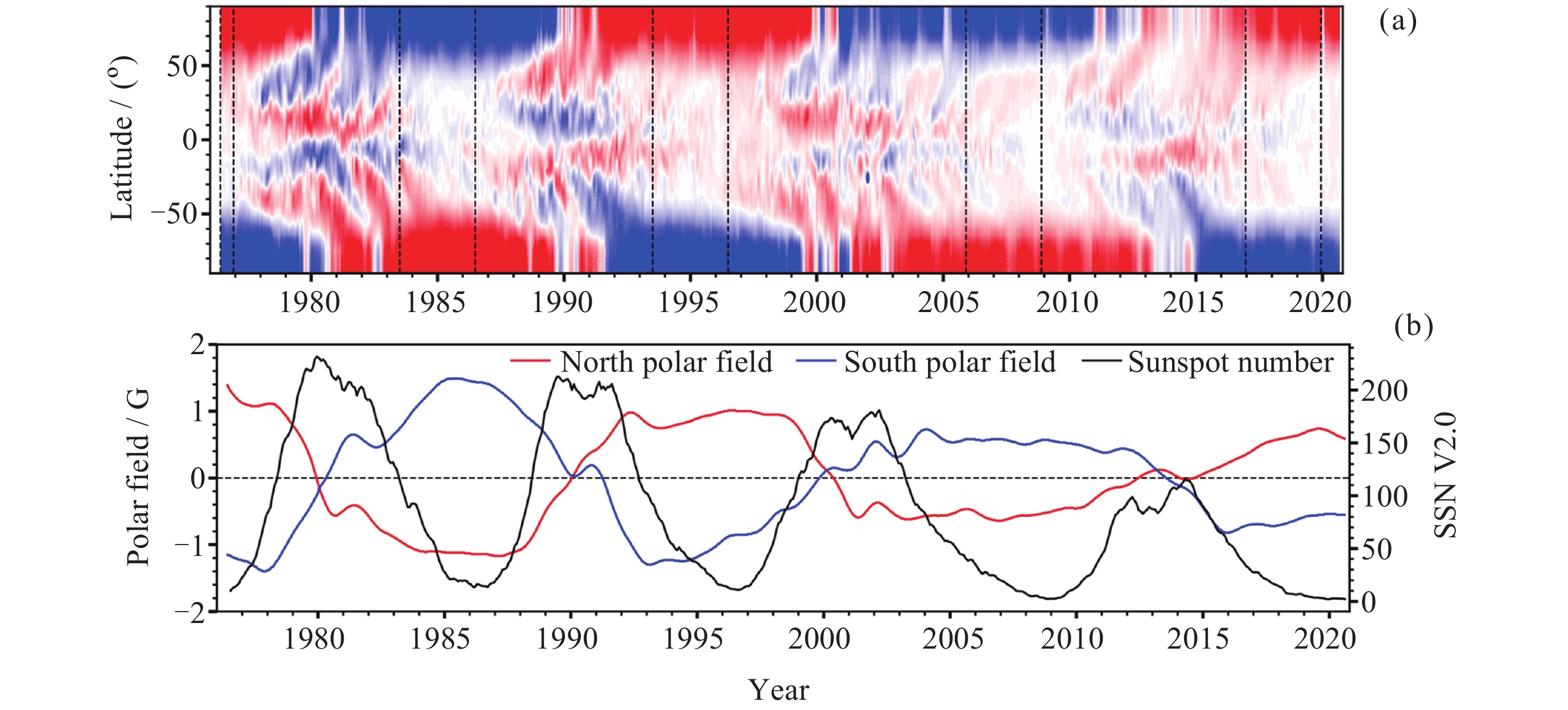
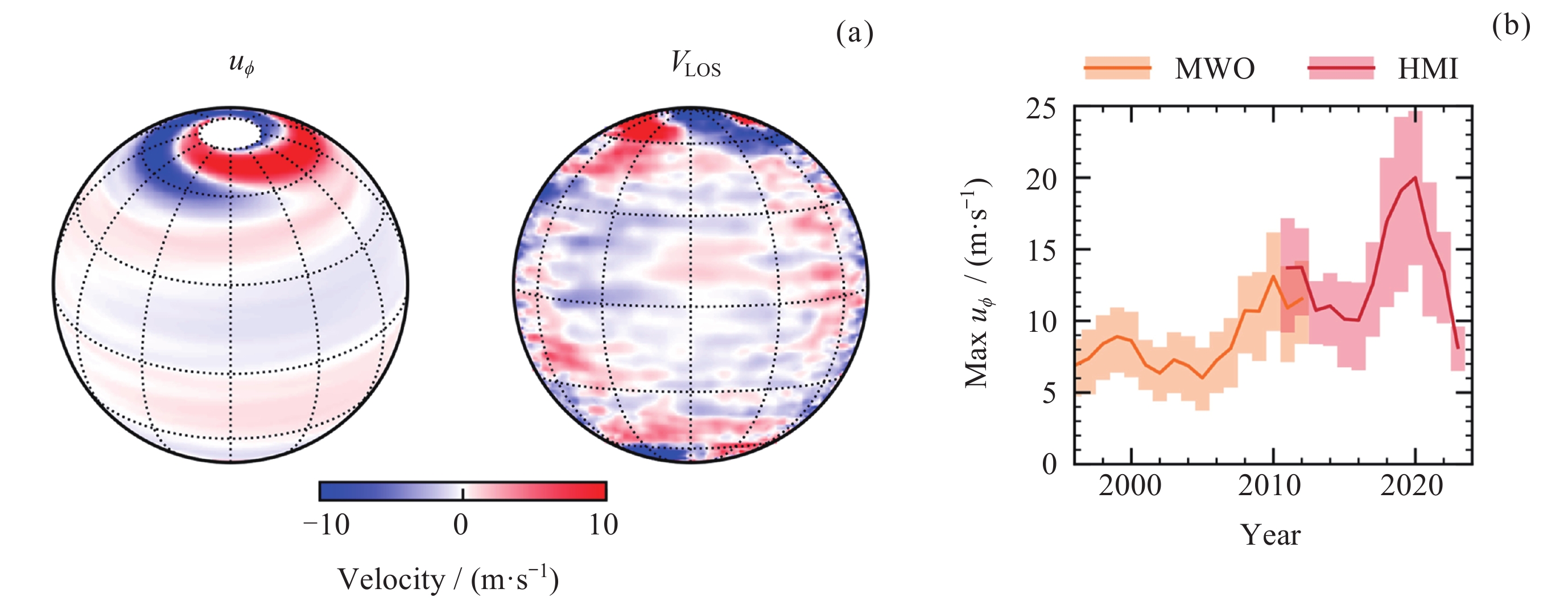
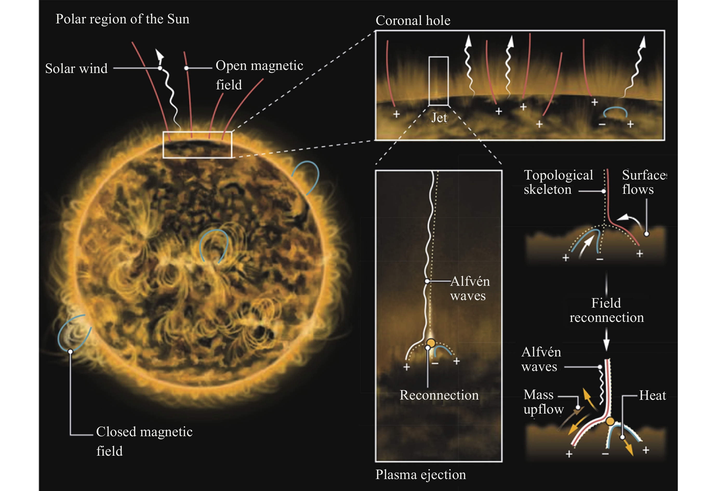
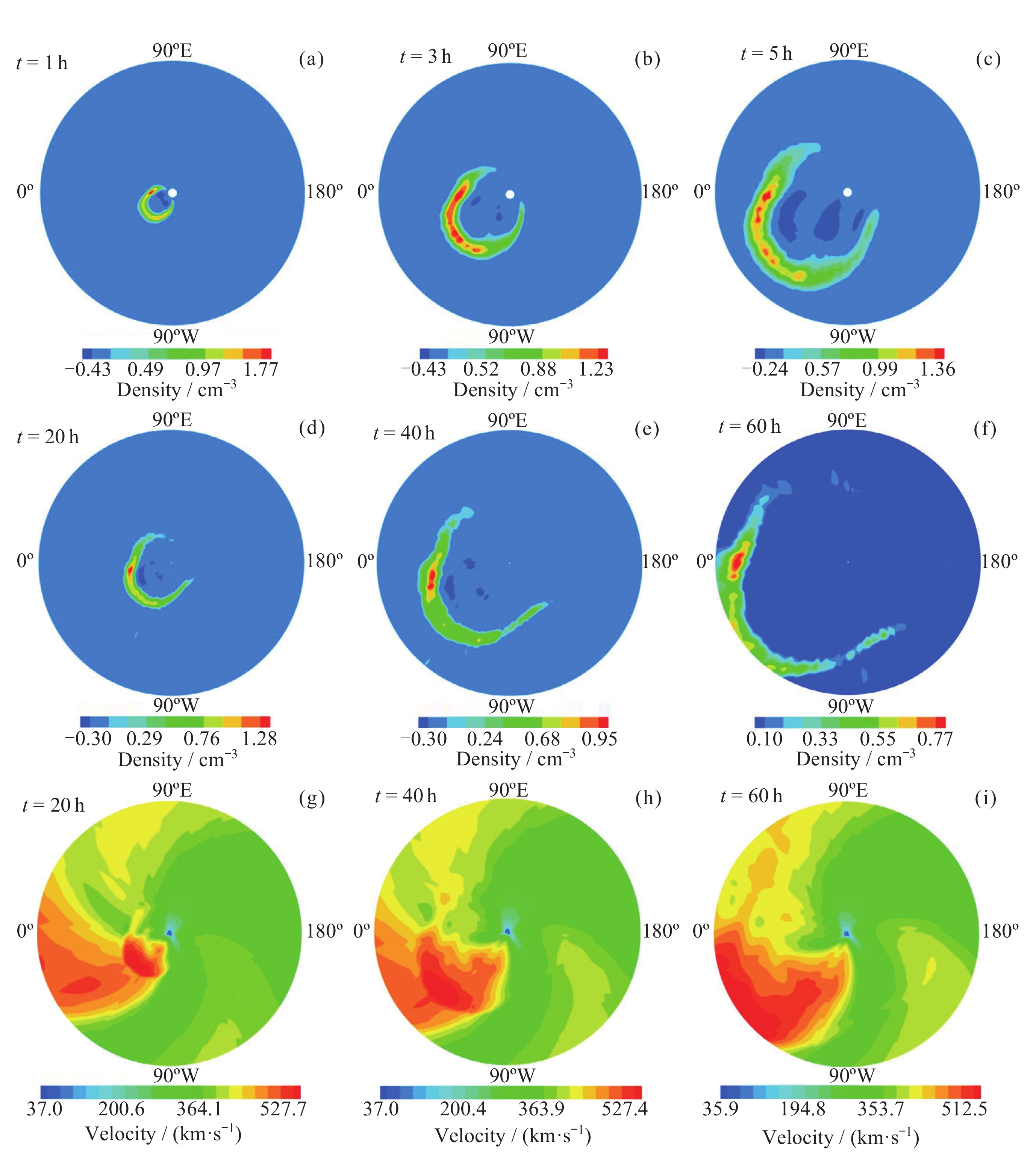
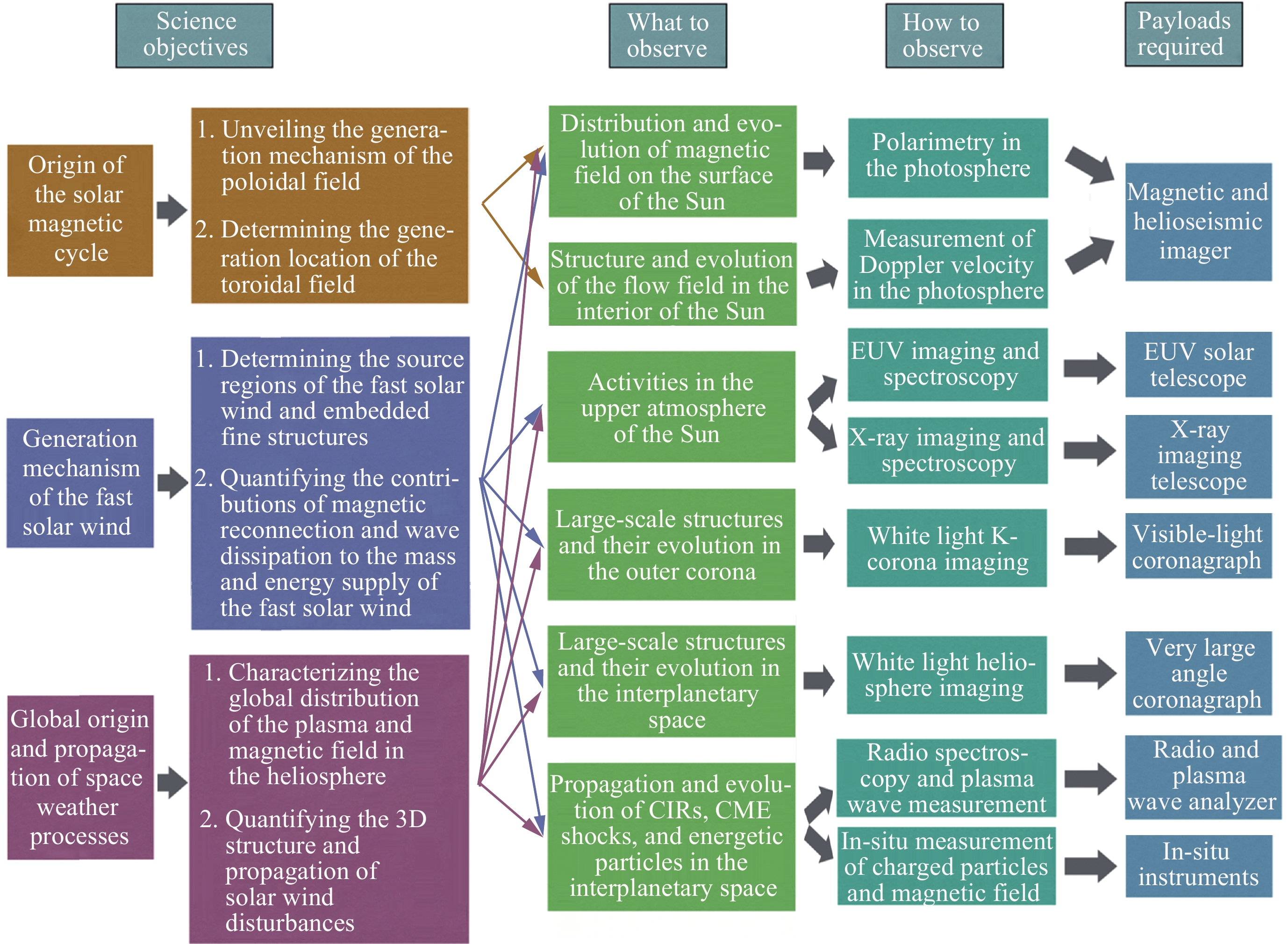
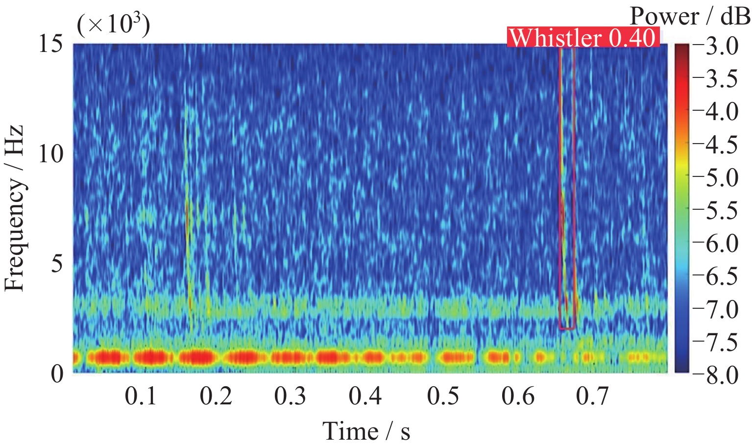
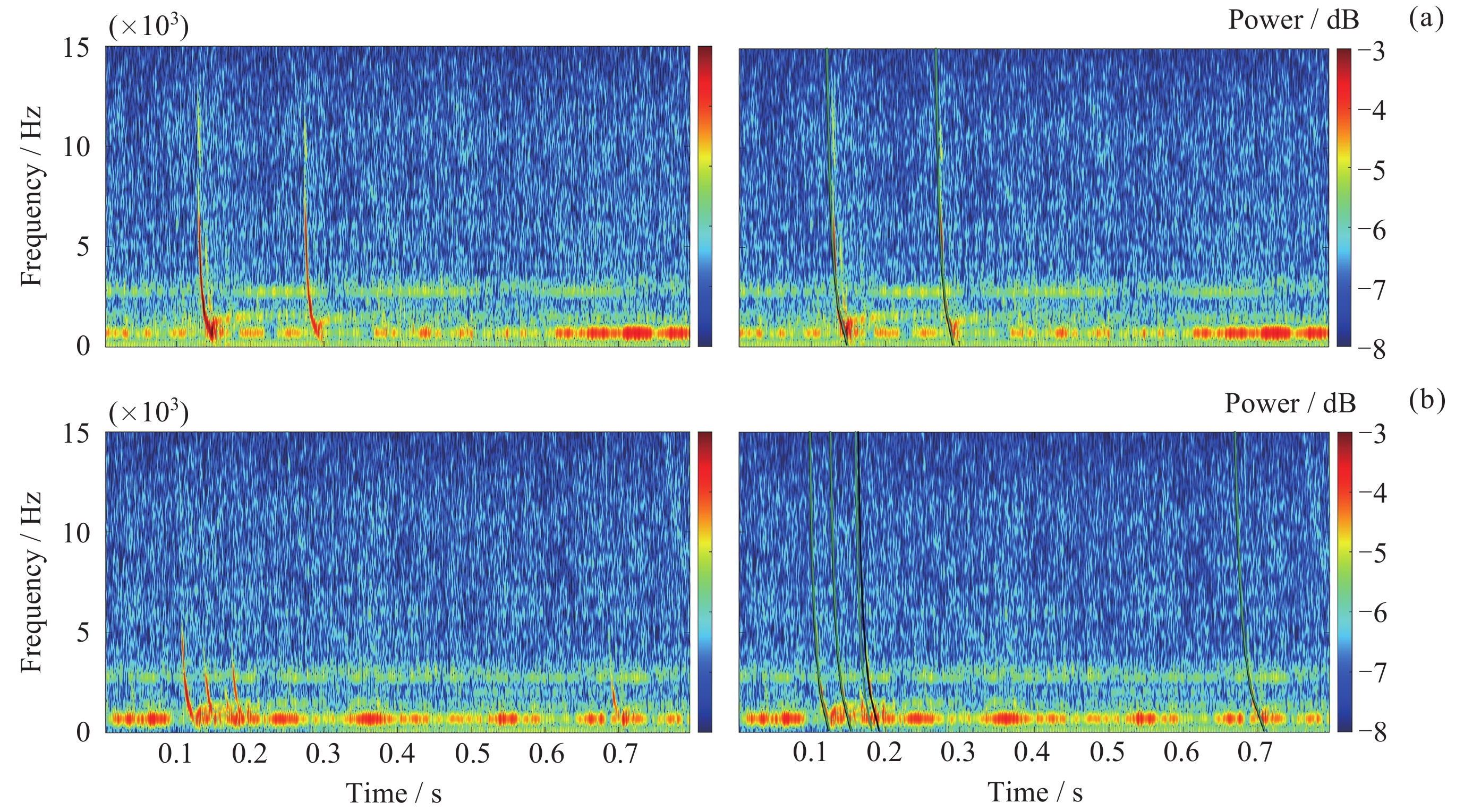
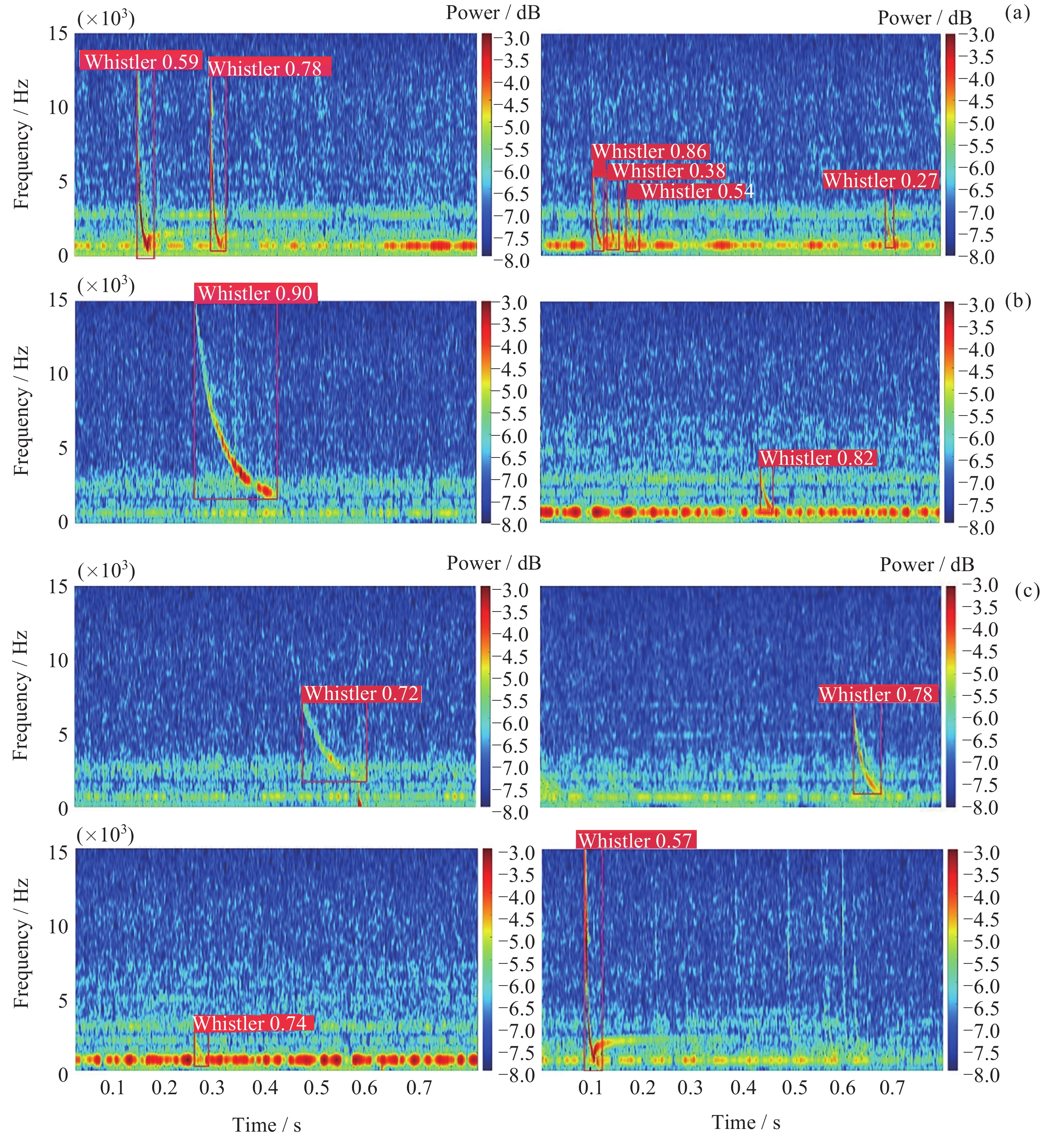
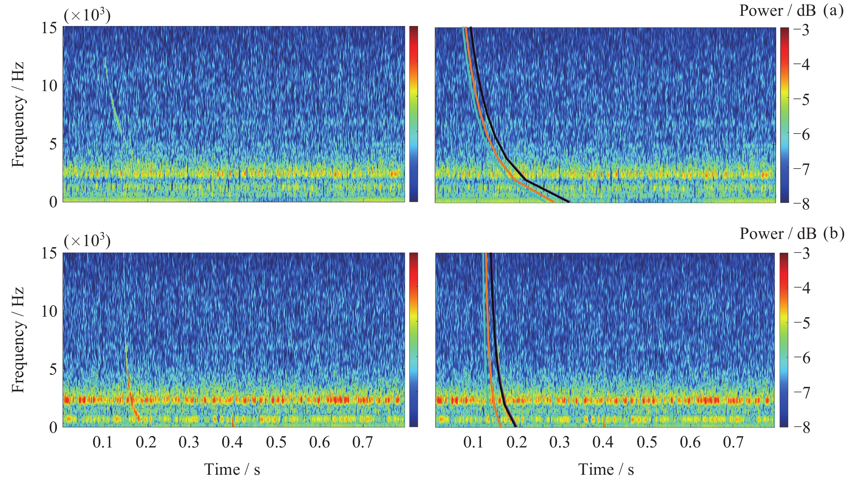
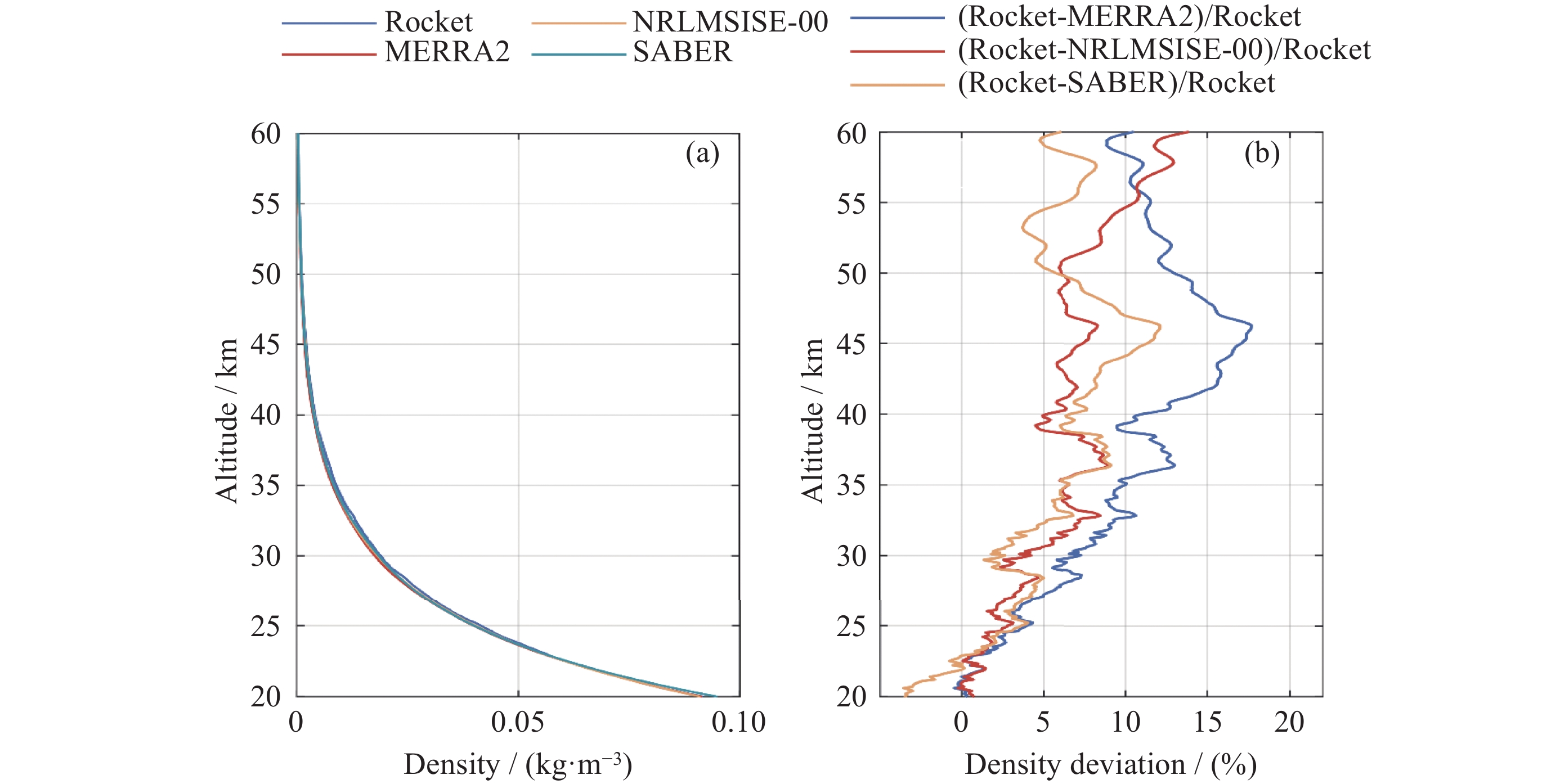
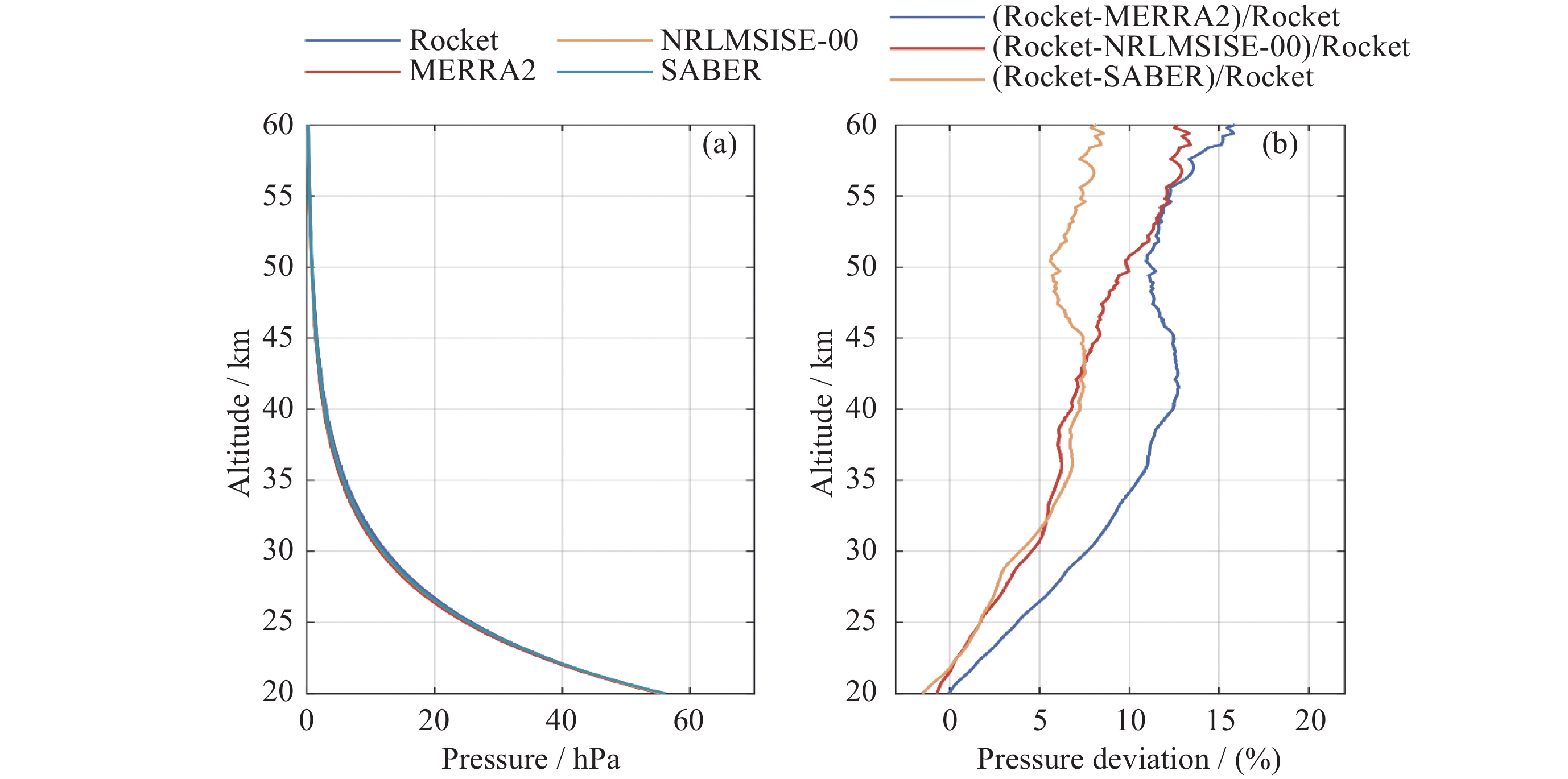
The magnetic fields and dynamical processes in the solar polar regions play a crucial role in the solar magnetic cycle and in supplying mass and energy to the fast solar wind, ultimately being vital in controlling solar activities and driving space weather. Despite numerous efforts to explore these regions, to date no imaging observations of the Sun’s poles have been achieved from vantage points out of the ecliptic plane, leaving their behavior and evolution poorly understood. This observation gap has left three top-level scientific questions unanswered: How does the solar dynamo work and drive the solar magnetic cycle? What drives the fast solar wind? How do space weather processes globally originate from the Sun and propagate throughout the solar system? The Solar Polar-orbit Observatory (SPO) mission, a solar polar exploration spacecraft, is proposed to address these three unanswered scientific questions by imaging the Sun’s poles from high heliolatitudes. In order to achieve its scientific goals, SPO will carry six remote-sensing and four in-situ instruments to measure the vector magnetic fields and Doppler velocity fields in the photosphere, to observe the Sun in the extreme ultraviolet, X-ray, and radio wavelengths, to image the corona and the heliosphere up to 45 Rs, and to perform in-situ detection of magnetic fields, and low- and high-energy particles in the solar wind. The SPO mission is capable of providing critical vector magnetic fields and Doppler velocities of the polar regions to advance our understanding of the origin of the solar magnetic cycle, providing unprecedented imaging observations of the solar poles alongside in-situ measurements of charged particles and magnetic fields from high heliolatitudes to unveil the mass and energy supply that drive the fast solar wind, and providing observational constraints for improving our ability to model and predict the three-dimensional (3D) structures and propagation of space weather events.
Geomagnetic Storm Image Recognition Based on Spectrogram and Convolutional Neural Network
LI Hongyu, SUN Junsong, WANG Li, YANG Jie, ZHAO Yuxin
2025, 45(4): 943-949. doi: 10.11728/cjss2025.04.2024-0066
Abstract:
Geomagnetic storms represent an important type of geomagnetic field disturbance that can cause interference and damage to fields such as communication, power supply, and aerospace technology. Therefore, the advancement and innovation of geomagnetic storm recognition technology have good development prospects for strengthening the application of geomagnetic storm data in related fields. In this study, we leveraged an extensive dataset comprising minute value recordings of horizontal components sourced from 12 permanent geomagnetic observation stations from 2010 to 2023. Employing spectral imaging technology, we conducted a comprehensive artificial intelligence-based image classification analysis to differentiate between geomagnetic storm days and geomagnetic quiet days, utilizing the VGG19 convolutional neural network model. We have obtained good experimental results. This experiment uses accuracy, precision, and recall as evaluation metrics. The experimental model demonstrated the accuracy rate of 97.41%, with a precision value of 98.00% and a recall rate standing at 96.80%. These indicators collectively emphasize the reliable predictive ability of our model. Furthermore, the application of spectrograms within the context of image recognition and classification has demonstrated significant feasibility. Notably, the VGG19 convolutional neural network model exhibited remarkable feasibility when tasked with categorizing geomagnetic storm days and geomagnetic quiet days. The recognition accuracy of this model for geomagnetic storm days is relatively high and the model itself is relatively stable. However, there is some fluctuation in the recognition of geomagnetic quiet days, which also means that the model still has room for further improvement, especially by increasing the number of training sets and improving the learning accuracy of the model for map information. In summary, our research findings contribute to the improvement of geomagnetic storm identification methods, providing a promising approach to enhance geomagnetic storm prediction and monitoring capabilities, and ultimately promoting the wider application of geomagnetic storm information in related fields.
Study of FY-3D Ionospheric Photometer (IPM) Response to the Extreme Magnetic Storm on 11 May 2024
JIANG Fang, MAO Tian, FU Liping, WANG Jinsong, HU Xiuqing, ZHANG Xiaoxin, WANG Yungang, JIA Nan, WANG Tianfang
2025, 45(4): 950-959. doi: 10.11728/cjss2025.04.2024-0079
Abstract:
With the launch of the FY-3D satellite on 15 November 2017, the far ultraviolet Ionospheric Photometer (IPM) on board enables measurements of nighttime 135.6 nm airglow emissions generated by the recombination of O+ ions and electrons, as well as daytime emissions from OI 135.6 nm and N2 LBH due to photoelectron impact on atomic oxygen and molecular nitrogen. These measurements can obtain the key parameters such as nighttime peak electron density NmF2 and daytime O/N2. The paper analyzes the response of IPM data during the extreme magnetic storm event on 11 May 2024. The study results of daytime data indicate that during the event, the O/N2 decreased at all latitudes compared to geomagnetically quiet days. This finding can be used to explain the negative storm effects observed in IGS TEC. The study of nighttime data reveals that during magnetic storms, the intensity of 135.6 nm increases significantly across all latitudes compared to geomagnetically quiet days, with an increase by up to three orders of magnitude. The enhancement persists from the storm main phase through the recovery phase. However, corresponding TEC data does not show such a pronounced increase. Furthermore, the stray light channel measuring radiation contribution above 190 nm wavelength also exhibits a significant increase during magnetic storm days. This further indicates that the enhancement of nighttime 135.6 nm radiation is not solely derived from ionospheric contributions.
Fast and Robust Automatic Extraction Method for the Lightning Whistler Scattering Coefficient of the Zhangheng Satellite
HAN Jinsheng, YUAN Jing, WANG Qiao, LIU Qinqin, YIN Hanke, LIU Haijun, ZHAO Shufan, SHEN Xuhui, WANG Yali
2025, 45(4): 960-974. doi: 10.11728/cjss2025.04.2023-0127
Abstract:
The daily production data of the Zhangheng satellite can reach up to 20 GB, rendering manual methods inadequate for handling such massive data demands. This paper proposes a rapid and robust Lightning Whistle Scattering Coefficient Automatic Extraction Method (LWSC-AEM). Firstly, detailed data from the Search Coil Magnetometer (SCM) of the Zhangheng satellite is extracted using a sliding window of 0.8 seconds, which is then transformed into time-frequency plots and audio files. Secondly, a YOLOV5 neural network is employed to automatically locate LW in the time-frequency plots and output their time-frequency position information. Subsequently, the corresponding audio data containing Lightning Whistlers is extracted based on this time-frequency position information from the files, and zero-padded to form audio segments of 0.8 seconds. Finally, the Mel Frequency Cepstral Coefficients (MFCCs) of the audio segments are extracted and fed into a Gate Recurrent Unit (GRU) improved with a multi-head attention mechanism to automatically extract the LW scattering coefficient. Applying this method to the data from the VLF band of the SCM payload of the Zhangheng satellite in February 2020 yields the following results: the average absolute error and average absolute percentage error are 0.453 and 0.176 respectively. Compared to the method by Ref. [1], the average absolute error is reduced by 1.079, a decrease of 70%, and the average absolute percentage error is reduced by 0.148, a decrease of 46%. The average processing time per data segment is 0.074 seconds, which is a reduction of 0.826 seconds, or 92%, compared to the method by Ref. [1], which processed each data segment on average. The automatic extraction method for lightning whistler wave scattering coefficients proposed in this paper can quickly and accurately extract these coefficients.
Use of NeQuick G Model and COSMIC-2 Occultation Data in Ionospheric Tomography Algorithm
YIN Ping, ZHANG Shanshan, XU Shuo, HOU Xiuze
2025, 45(4): 975-986. doi: 10.11728/cjss2025.04.2024-0077
Abstract:
As effective means of ionospheric monitoring, NeQuick G model and Global Navigation Satellite System (GNSS) Constellation Observing System for Meteorology Ionosphere and Climate 2 (COSMIC-2) have been providing plenty of information for characterizing ionospheric conditions. For example, the NeQuick G model is an empirical model that can offer estimated ionospheric electron density and Total Electron Content (TEC) data at any given time and location, while COSMIC-2 yields measured electron density profiles via radio occultation techniques, thus providing direct observations of vertical ionospheric structures. With the development of ionospheric tomograhic techniques based on GNSS data, four-dimensional (spatio-temporal) distribution of electron density can be reconstructed globally even during periods of ionospheric disturbances. However, such tomographic techniques are often limited by uneven data coverage (non-uniform distribution of observation paths) and low vertical resolution in the inversion, which may reduce reconstruction accuracy. In this study, an improved three-dimensional ionospheric tomography approach is presented, adapting the Multi-Instrument Data Analysis System (MIDAS) algorithm to integrate NeQuick G model electron density profiles and COSMIC-2 occultation observations. By incorporating a background model and direct profile measurements, the tomography inversion receives additional constraints that help mitigate issues of data sparsity and improve vertical structure accuracy. Take a case study as an example, this improved MIDAS tomographic method is applied to reconstruct the ionospheric electron density distribution over the Wuhan station (WU430), China and one South Korean station (JJ433) during the period of ionospheric disturbance between November 3 and 4 in 2021. Besides, ionosonde observation data from these two stations are used as the independent measurements to evaluate the inversion results in term of peak electron density (NmF2) and peak height (hmF2) of the F2 layer, as well as electron density profiles. The comparsion results show that the improvement percentage of the Root Mean Squared Error (RMSE) of NmF2 tomographic results was up to 30.7%, and the RMSE improvement percentage of hmF2 tomographic results was up to 59.21%.
Study on Ionospheric Absorption Variation Characteristics in the Northwest Corrido
XIN Hao, ZHAO Haisheng, WANG Junjiang, GE Shucan
2025, 45(4): 987-994. doi: 10.11728/cjss2025.04.2024-0075
Abstract:
Ionospheric fmin is the lowest echo frequency observed on the frequency height map, which is an important index of the performance of the ionosonde and also an important index for the study of the absorption effect in the ionospheric D region. In this paper, the ionospheric absorption intensity, spatial distribution, diurnal variation, seasonal variation and long-term variation are studied by using ionospheric fmin data from Xi’an, Urumqi and Lanzhou stations of China ionospheric vertical survey network in the Northwest Corridor region. The study of ionospheric absorption variation is of great application value to the selection of the lowest frequency of shortwave communication, the evaluation of detection performance of sky-wave over-the-horizon radar and the prediction of VLF telecommunication efficiency. At the same time, ionospheric absorption is closely related to the electron density of the D layer, which is an important indicator of the intensity of the electron density of the D layer. To study the ionospheric absorption characteristics is of great scientific significance for the study of the ionospheric variation characteristics and the establishment of the electron density distribution model in the D region. The absorption effect of ionospheric region D in the Northwest Corridor mainly occurs in the daytime, with the highest absorption intensity at noon and the weakest in the early morning at night. Meanwhile, the absorption effect of ionospheric region D in the Northwest Corridor has significant seasonal variation characteristics, the strongest in summer and the weakest in other seasons. The ionospheric fmin value of Urumchi at higher latitude is obviously higher than that of Xi’an and Lanzhou at middle latitude, and the absorption effect center has obvious diurnal drift characteristics. The absorption of ionospheric region D in the Northwest Corridor is positively correlated with the intensity of solar activity. In particular, the absorption intensity of ionospheric region D in high solar activity years is significantly higher than that in low solar activity years.
Uncertainty Evaluation of Atmospheric Temperature Retrieval Using Rayleigh Lidar Based on the Optimal Estimation Method
ZHANG Xiaojian, ZHANG Xianzhong, LI Xinqi, WU Tong, ZHONG Kai, YAN Zhaoai, XU Degang, YAO Jianquan
2025, 45(4): 995-1006. doi: 10.11728/cjss2025.04.2024-0081
Abstract:
As a new retrieval method, the Optimal Estimation Method (OEM) is playing an increasingly important role in detecting the atmospheric environment by lidar. In this study, the necessity of calculating the uncertainty of retrieval results was analyzed first. To characterize the reliability of the atmospheric temperature inversion results by lidar, the OEM uncertainty formula was derived and the sources of uncertainty was clarified. There were four sources of uncertainty, which were smoothing uncertainty, model parameter uncertainty, forward model uncertainty and noise uncertainty. Regarding the problem of using Rayleigh lidar to retrieve the temperature of the middle atmosphere, the forward model was derived based on the lidar equation, ideal gas state equation, and hydrostatic equilibrium as reasonable assumptions. Based on the simulated echo photon profiles of the Rayleigh lidar calculated by forward model, the middle atmospheric temperature and the corresponding uncertainty was calculated, which demonstrated that the main uncertainty sources in the OEM retrieval process are the reference pressure uncertainty and noise uncertainty. Using the Monte Carlo Method (MCM), the OEM uncertainty verification framework was established and the uncertainty values generated by different sources of uncertainty were verified. Afterwards, the total uncertainty value caused by all sources of uncertainty was also verified. Results showed that the uncertainty calculated by two different methods and the total uncertainty were consistent below the altitude of 85 km, proving the accuracy of the OEM uncertainty theories. In addition, temperature retrieval based on measured results by Rayleigh lidar was performed. The characteristics of the measured data were introduced in detail, and the retrieval results and corresponding uncertainties were calculated. The results prove the conclusion that the main uncertainty sources in the OEM inversion process are the reference pressure uncertainty and noise uncertainty. The work of this article paves the way for the applications of lidar in monitoring the atmospheric environment.
Analysis and Evaluation of Data from Near Space Meteorological Rocket Detection over Northwest Area in 2023
HE Yang, CHEN Tailong, HUANG Jiangping
2025, 45(4): 1007-1015. doi: 10.11728/cjss2025.04.2024-0074
Abstract:
Meteorological rocket is an important in-situ detection method to obtain the fine structure of vertical distribution of atmospheric environment in near space, the detection results should have higher accuracy than ground-based or space-based remote sensing detection. Objective evaluation of the data quality is an important prerequisite for the effective use of the data. In this paper, the atmospheric temperature, wind field, density, and pressure in the altitude range of 20~60 km are obtained by using a meteorological sounding rocket launched in Qinghai in winter of 2023. The error correction of the temperature measured by thermistors is carried out. The detection results are compared with the data of remote sensing detection, empirical prediction model and reanalysis data. The results show that the rocket wind field results are in good agreement with the MERRA2 data, and the HWM empirical forecast model cannot accurately describe the atmospheric environment in the corresponding region. The measured temperature error of the rocket is gradually prominent when it is over 40 km, and the main error terms are current heating term, temperature hysteresis term and pneumatic heating term. The corrected temperature is in good agreement with the reference data, and the main difference of temperature data from different sources is that the height of the temperature inflection point in the stratosphere is different. The deviation of pressure and density results increases with altitude. The analysis believes that the quality of the rocket’s detection data is good and the accuracy is high. Through the analysis and evaluation of the data, the effectiveness and reliability of the mathematical model of atmospheric element inversion are verified.
Space Exploration Technology
Arc Second Pointing System of Near Space Observatories WASP
CUI Yulang, LI Yijian, ZHOU Jianghua
2025, 45(4): 1016-1037. doi: 10.11728/cjss2025.04.2024-0094
Abstract:
The Wallops Arc Second Pointer (WASP), developed by the National Aeronautics and Space Administration (NASA) in response to the challenge of sub-arcsecond-level pointing stability for high-altitude scientific balloon platforms during long-duration observational missions, is a near-space observatory-grade sub-arcsecond pointing system designed to establish a multi-payload-compatible near-space astronomical observation platform. Comprising a Pointing Control System (PCS) and a star tracker subsystem (Camera Attitude Reference Determination System, CARDS), WASP serves as the core technology for achieving high-precision fine-pointing control in near-space environments. By integrating precision mechanical and electronic components with super-pressure balloon technology, the system enables extended-duration missions in near-space while maintaining sub-arcsecond-level pointing accuracy. Its modular design and standardized interfaces allow seamless adaptation to diverse scientific payloads, fulfilling varied mission requirements. To transition early-stage ground-test hardware and software from laboratory settings to real-world flight conditions, the WASP team collaborated with multiple research groups to conduct five successive test flights. These flights validated the system's technical methodologies and performance capabilities while enabling further optimizations based on operational mission requirements. Following the completion of WASP’s development phase, the system has engaged in scientific collaborations with numerous research teams, producing notable achievements. Since 2014, WASP has supported missions including the X-Calibur hard X-ray polarimeter, BITSE (Balloon-borne Investigation of Temperature and Speed of Electrons in the corona), PICTURE-C (Planetary Imaging Concept Testbed Using a Recoverable Experiment-Coronagraph), SuperHERO (Super High-Energy Resolution Observatory), and XL-Calibur, yielding groundbreaking scientific results across astrophysics and planetary science domains. In the field of space science, WASP not only expands the research scope of high-altitude balloon platforms but also provides innovative solutions for constructing near-space observatories, advancing the exploration of near-space environments. The successful test flights and operational deployments of WASP have laid a foundation for its applications in planetary science, astrophysics, and Earth observation, while offering a reliable reference for the development of near-space science in China.
Analysis of COSMOS 1408 Debris Cloud Evolution
MO Xingjian, LIANG Wei, ZHAO Xianglei, LEI Xiangxu, ZHAO You
2025, 45(4): 1038-1046. doi: 10.11728/cjss2025.04.2024-0089
Abstract:
The number of spacecrafts in Earth orbit continues to increase, leading to growing density in near-Earth space. Statistics show that existing space debris primarily originates from approximately 640 breakup events. Studying satellite breakup events is crucial for maintaining space environment safety. On 15 November 2021, Russia conducted an anti-satellite test, destroying a defunct satellite — COSMOS 1408. The event generated a debris cloud consisting of approximately 1800 trackable debris distributed across altitudes ranging from 200 km to 1400 km, which disperses and evolves over time, posing threats to Low Earth Orbit (LEO) satellite operations. Based on the Two-Line Element (TLE) data of COSMOS 1408 breakup event debris released by the U.S. Space Surveillance Network (SSN), this paper utilizes the Simplified General Perturbations 4 (SGP4) model to analyze the evolution of the debris cloud. The analysis primarily covers the cataloged quantity and spatiotemporal changes of the debris cloud, variations in main orbital parameters, and the impact of breakup debris on the space environment. Taking the International Space Station’s (ISS) four debris avoidance maneuvers as examples, this study investigates the evolution patterns and resulting impacts, preliminarily reconstructing the evolution process of the COSMOS 1408 anti-satellite event debris cloud and its consequences.
Noise and Index Decomposition of Taiji-2 Interferometer System
LIU Heshan, WANG Juan, GAO Ruihong, QI Keqi, WANG Shaoxin, LI Pan, GAO Xuerong, LUO Ziren
2025, 45(4): 1047-1057. doi: 10.11728/cjss2025.04.2025-yg02
Abstract:
The Taiji program for space-based gravitational wave detection is a mission initiated by the Chinese Academy of Sciences to explore gravitational waves in the mHz frequency band. It consists of three satellites orbiting the Sun in an equilateral triangle formation with an arm length of 3×10⁶ km, employing laser interferometry to measure picometer-level displacement fluctuations between satellites. As a pivotal link in Taiji’s “three-step” development strategy, Taiji-2 will comprehensively validate all key technologies of the program. The satellite configuration of the Taiji-2 satellite shares the same configuration as Taiji-3, with its laser interferometry system requiring a noise level of 30 pm·Hz–1/2 as the core measurement technique. This paper systematically decomposes the top-level requirements into subsystem noise budgets and key parameters, including the laser system, interferometer optical bench, phasemeter, telescope, and breathing angle compensation mechanism. The research findings establish a theoretical foundation for subsequent engineering task allocation in the Taiji-2 mission.
Thermal Wave Transfer Characteristics in Ultra-low Thermal Conductivity Materials
HONG Sihui, ZHOU Yupeng, ZHAO Xin
2025, 45(4): 1058-1066. doi: 10.11728/cjss2025.04.2024-0101
Abstract:
Considering a single ultra-low thermal conductivity insulation material, the transfer process of external heat flow noise in a single stage insulation material is modeled by using generalized thermoelasticity theory and one-dimensional thermomass theory. Combined with the CV model of one-dimensional Fourier heat conduction theory, the damping oscillation model of temperature was proposed, and the quasi-steady transfer process of external heat flow in single-layer materials was modeled. The functional relationship of temperature noise response to external heat flow noise was constructed, and the corresponding characteristics of node temperature were obtained. Through sensitivity analysis, the key parameters and their influencing rules of temperature noise attenuation were clarified.
Common Mode Error Analysis of GNSS Coordinate Time Series in Northwest China Based on MSSA Algorithm
LIANG Bin, YU Mingxue
2025, 45(4): 1067-1078. doi: 10.11728/cjss2025.04.2024-0072
Abstract:
Aiming at the problem that the common mode error analysis of the vertical coordinate time series of the Global Navigation Satellite System (GNSS) in Northwest China is not comprehensive and in-depth, the MSSA algorithm is used as the theoretical basis to preprocess the data of 61 stations in the three northwestern provinces (Xinjiang, Gansu, Qinghai) to improve the accuracy and integrity of the data, and on this basis, the common mode error of GNSS coordinate time series in the region is extracted and analyzed. The characteristic source of the Common Mode Error (CME) was investigated by correlation analysis between the extracted CME and the displacement time series caused by Hydrologic Load (HYDL), Non-Tidal Atmospheric Load (NTAL) and Non-Tidal Ocean Load (NTOL). Compared with the sequence before and after the removal of the common mode error, the average accuracy of the residual standard deviation is increased by 27.5%, and the maximum reduction of the station is reduced by 66.7%. The results show that the common mode error in this region is significantly affected by three kinds of surface mass loads: hydrologic load, non-tidal atmospheric load and non-tidal ocean load. Through the extraction and analysis of common mode errors and the research on the source of error characteristics, the GNSS coordinate time series accuracy of the three northwestern provinces can be further improved, so as to provide higher precision data support for seismic displacement and crustal deformation research.
Study on Service Performance of Single Frequency SBAS in Algerian Satellite-based Augmentation System
PAN Lijing, WANG Ling, JIN Biao, WANG Leilei, LIU Ningning, ZHAO Liqian, WANG Shaoxian, JING Hui
2025, 45(4): 1079-1086. doi: 10.11728/cjss2025.04.2024-0078
Abstract:
The Algerian Satellite-based Augmentation System (ALG-SBAS) is a Satellite-based Augmentation System (SBAS) based on the Algerian communications satellite 1 (Alcomsat-1), which is already in its official operational phase. In order to deeply understand the system service type and performance, this paper first introduces the system, and then evaluates the stability of the broadcast message of the Geosynchronous Orbit (GEO) satellite, ionospheric delay correction accuracy, positioning accuracy and integrity. The results show that ALG-SBAS GEO satellite has strong stability. The ionospheric delay correction percentage is better than 87%. The positioning accuracy of The positioning accuracy of ALG-SBAS is significantly improved than that of GPS positioning, and the average positioning accuracy is increased by more than 39%. The average SBAS PPP 3D positioning accuracy of all stations is better than 0.45m. The positioning accuracy is compared with EGONS, and the results show that ALG-SBAS is slightly worse than EGONS. At the same time, the integrity of the station positioning results was analyzed, and no integrity risk events occurred in ALG-SBAS during the evaluation period. ALG-SBAS had an average availability of 99.9% at all stations in the Approach with Vertical Guidance-I (APV-I) phase. The service performance of the satellite-based augmentation system meets the single frequency service index and can provide single frequency SBAS service.
Anomaly Detection Method for Satellite Telemetry Parameters Based on Time-series Imputation Generative Adversarial Networks
DU Xiaolong, BAI Meng
2025, 45(4): 1087-1097. doi: 10.11728/cjss2025.04.2024-0099
Abstract:
To ensure the safe and stable operation of satellites, it is of paramount importance to promptly conduct data mining, situation analysis, and abnormal response for telemetry parameters. Given the limitations of existing methods in effectively addressing satellite telemetry parameter anomalies, this paper introduces an innovative anomaly detection method that leverages temporal interpolation and Generative Adversarial Networks (GANs). The proposed method employs a one-dimensional Convolutional Neural Network (1DCNN) to extract temporal features from the telemetry data. These features are then used to model the distribution of telemetry parameters through a generative adversarial network, which consists of a generator and a discriminator that are trained simultaneously to learn the distribution of normal data. The method innovatively incorporates a detection approach based on interpolation, which significantly enhances the accuracy of anomaly detection and the capability to handle complex and subtle anomalies that may not be easily identified by traditional methods. The effectiveness of the proposed method is validated through comprehensive testing on real satellite data as well as established public datasets. Results demonstrate that, when compared with various existing anomaly detection methods, the proposed approach achieves the highest F1 scores on the majority of the datasets tested. This indicates a superior balance between precision and recall, which is crucial for reliable anomaly detection. Furthermore, the method exhibits good stability under different anomaly densities, suggesting its robustness in varying operational conditions. This research outcome not only enhances the understanding of satellite telemetry anomalies but also provides strong decision support for ground operation in satellite mission analysis and anomaly handling, thereby contributing to the overall safety and efficiency of satellite operations.
Design of the EP Satellite Data Preprocessing and Distribution Service Platform
MA Fuli, JI Zhen, YANG Xiaoyan, YU Qinsi, LI Bing, LUO Wentian, TONG Jizhou
2025, 45(4): 1098-1113. doi: 10.11728/cjss2025.04.2024-0092
Abstract:
Along with the development of space exploration technology and the communication methods between satellite and the Earth, the requirements for the efficiency of data transmission and processing in astronomical missions are increasing day by day. The article introduces the design and implementation of a data preprocessing and distribution platform, which focuses on the processing and distribution requirements of various types of data in the Einstein Probe (EP) mission. The EP mission downlinks data via four different channels, including X-band, S-band, VHF channel, and Beidou channel. For each data channel, the data processing methods and efficiency requirements are different, such as the VHF and Beidou data needs to be processed in real-time, the X-band data needs to be processed comprehensively by different types of data packets. During the development process, the key technologies of the EP satellite data preprocessing and analysis platform have been studied. At the meanwhile, several key algorithms have been designed, such as the Level 0 data processing method, Level 1 data processing method and data product integrity interpretation based on observation organization. Especially, regarding the high timeliness requirements for the release of astronomical alert information in VHF data and Beidou short messages, different priority data preprocessing and distribution workflows were designed. The EP mission data preprocessing and distribution service platform adopts a hierarchical architecture design. The application results indicate that the platform has the ability to preprocess, manage and distribute various types of data in EP mission automatically, efficiently, and accurately. The operational process of the platform supports the different processing flows for different data products and simultaneous data distribution and acquisition for multiple users. The platform has good scalability and efficiency. The various levels and types of scientific data products processed by the platform have high accuracy, can satisfy the application requirements of EP scientific teams.
Design and Implementation of Satellite Status Processing and Monitoring System Based on Multi-channel High-rate Frame Processing
CAI Jiji, YU Yeluo, YANG Shujie, LI Wei, CHEN Yujun, ZHOU Da
2025, 45(4): 1114-1122. doi: 10.11728/cjss2025.04.2024-0056
Abstract:
The stable establishment of space-ground communication channels enables the ground control center to receive telemetry data, tracking and control signals, as well as scientific and observational data from the satellite. Satellite telemetry data serves as an important basis for reflecting the working status of various subsystems and individual equipment on the satellite during its on-orbit operation and is also the basis for judging satellite faults, which are divided into real-time telemetry and delayed telemetry data. Real-time telemetry data are the telemetry data collected in real-time by the satellite, which can truly reflect the working status of the satellite; delayed telemetry data are compressed real-time telemetry data, where the time interval between adjacent sampling points during compression is long. The construction of the satellite status quantity processing monitoring platform aims to process and display the status data from the satellite downlink according to specific protocols through software systems, mainly including satellite data acquisition and processing, real-time monitoring and status analysis, anomaly detection and alarming, and satellite health management. Facing the traditional on-orbit satellite downlink data channels, which include satellite telemetry channel data and data transmission channel data, the telemetry channel data refers to the downlink data of the S-band telemetry channel, while the data transmission channel data refers to the engineering parameters of the data transmission. Considering the characteristics of the data transmission channel data, such as high rate, dual channels, and multiple application modes, a satellite status quantity processing monitoring system has been designed. This system is not only capable of processing multi-channel data but also performs framing processing, parsing, display, querying, storage, and exception alarming for high-speed data transmission engineering parameters. In addition, this software has been successfully applied to the mission operation control system of on-orbit satellites, meeting the real-time monitoring needs for satellite platform models and payloads.
Lightweight Yolov5 Algorithm Target Detection System Based on Space-grade NPU
LIU Bing, ZHOU Hai, BIAN Chunjiang, CHENG Xiaolei, WANG Pengfei, ZHANG Biao
2025, 45(4): 1123-1133. doi: 10.11728/cjss2025.04.2024-0103
Abstract:
With the continuous progress and expansion of space exploration missions, the quantity of remote sensing images that need to be processed has been increased substantially. In such a context, the target detection systems are confronted with ever-higher demands in terms of robustness and timeliness. The traditional approach of transmitting a large volume of remote sensing data back to the ground for processing has become infeasible due to various limitations such as communication bandwidth and time delay. To address this critical issue, this research focuses on the on-orbit target detection system of remote sensing images, which is based on the astronautics-grade Neural Network Processor (NPU). Specifically, the Yolov5s network is taken as the foundation and optimized. The components with relatively low compatibility with the NPU are replaced, and an attention mechanism is incorporated. This not only overcomes the challenges that the complex network structure and excessive computational requirements of deep learning-based object detection algorithms pose for deployment on satellite processing platforms with limited resources, but also compensates for potential losses in network accuracy. The optimized network is trained iteratively on the GPU using the public dataset VOC. After the CPU-NPU parallel co-processing design, the three main aspects of image processing, namely image preprocessing, feature extraction, and target classification and localization, are executed in parallel. This approach maximizes the utilization of the limited computing and storage resources of the Yulong810A platform. Experimental results demonstrate that when the optimized network is deployed on the Yulong810A on-board processing platform, it achieves remarkable improvements. The number of parameters is significantly reduced by 75%, and compared with the original Yolov5s network, the accuracy is enhanced. The mean Average Precision (mAP) value reaches 71.25%, and the target detection speed attains 47.67 frames per second (fps), which is more than twice the speed of the original Yolov5s network. In summary, this research realizes a more lightweight and faster object detection system, which holds great potential for promoting the development and efficiency of space exploration missions.
Two-stage Contour Detection Method for Small-scale Disk-resolved Celestial Datasets
ZHENG Yang, LI Dan, LIANG Zuzhong, CHENG Yong, ZHENG Zhongjie
2025, 45(4): 1134-1148. doi: 10.11728/cjss2025.04.2024-0086
Abstract:
In the astrometry of the disk resolved objects, contour detection acts as an important step, and it is equivalent to a binary classification process of classifying pixel points as contour points and non-contour points. For the purpose of automated extraction of hierarchical contour features, enhancement of contour detection precision, and accommodation of either limited-scale disk-resolved celestial datasets or preliminary-phase observational campaigns, a two-stage contour detection method for small-scale disk-resolved celestial datasets is proposed in this paper. In the first stage, a window contour detection method utilizing digital image processing techniques and comprising three operational steps: window extraction, window searching, and elliptical fitting, is employed to perform initial contour extraction. The second stage introduces an LPC-ResNet classifier, an adapted version of ResNet architecture, to supplement potential contour points missed by the window-contour detection method in the first stage. Experimental validation using New Horizons’ Long-Range Reconnaissance Imager (LORRI) images of Pluto and its biggest satellite Charon demonstrates that the window-based method achieves optimal Precision, indicating its superior capability in filtering non-contour pixels, yet exhibits limited Recall, likely due to unintended exclusion of contour points during elliptical fitting in the window-contour detection method. After incorporating the LPC-ResNet classifier, both Recall and F1 score are improved, enhancing the ability to retain contour points and resulting in more complete contour extraction. To further validate the role of LPC-ResNet classifier in refining detection outcomes, centroid measurement experiment of Pluto and Charon is conducted using the contours extracted by the two-stage detection method and the single window-contour detection method, using the ephemerides Plu060 as the reference. The results of the experiment demonstrate that the two-stage method reduces mean and standard deviation of the Observed-minus-Calculated (O-C) residuals in both x and y directions, which means that the two-stage method has higher detection precision compared to the single window-contour detection method, confirming that LPC-ResNet classifier can improve the contour extraction effect of the window-contour detection method.